Related Research Articles

The London Borough of Islington is a London borough which forms part of Inner London, England. Islington has an estimated population of 215,667. It was formed in 1965, under the London Government Act 1963, by the amalgamation of the metropolitan boroughs of Islington and Finsbury.

Canonbury is a residential area in London, forming part of the London Borough of Islington. It is roughly in the area between Essex Road, Upper Street and Cross Street and either side of St Paul's Road in North London.

Holloway is an area of north London in the London Borough of Islington, England, 3.3 miles (5.3 km) north of Charing Cross, which follows the line of the Holloway Road (A1). At the centre of Holloway is the Nag's Head commercial area which sits between the more residential Upper Holloway and Lower Holloway neighbourhoods. Holloway has a multicultural population and includes the Emirates Stadium, home of Arsenal F.C.. Until 2016, it was the site of Holloway Prison, the largest women's prison in Europe. Before 1965, it was in the historic county of Middlesex.

Islington is a district in the north of Greater London, England, and part of the London Borough of Islington. It is a mainly residential district of Inner London, extending from Islington's High Street to Highbury Fields, encompassing the area around the busy High Street, Upper Street, Essex Road, and Southgate Road to the east.

Etobicoke is an administrative district and former city within Toronto, Ontario, Canada. Comprising the city's west-end, Etobicoke is bordered on the south by Lake Ontario, on the east by the Humber River, on the west by Etobicoke Creek, the cities of Brampton, and Mississauga, the Toronto Pearson International Airport, and on the north by the city of Vaughan at Steeles Avenue West.

Old Street is an interchange station at the junction of Old Street and City Road in Central London for London Underground and National Rail services.
Farringdon is an area in London and is located in the London Borough of Islington. It lies just north of the border with the City of London in Central London and close to Holborn. The term is used to describe the area around Farringdon station.

Pentonville is an area in North London, located in the London Borough of Islington. It is located 1.75 miles (2.82 km) north-northeast of Charing Cross on the Inner Ring Road. Pentonville developed in the northwestern edge of the ancient parish of Clerkenwell on the New Road. It is named after Henry Penton, the developer of the area.

The New North Road is a road in northern central London, forming part of a link road from the A1 at Highbury into the City of London at Moorgate. It is 0.8 miles (1.3 km) in length and is part of the A1200. This link road consists of Canonbury Road and New North Road, before several smaller sections to the south leading into the city.

The Angel, Islington, is a historic landmark and a series of buildings that have stood on the corner of Islington High Street and Pentonville Road in Islington, London, England. The land originally belonged to the Clerkenwell Priory and has had various properties built on it since the 16th century. An inn on the site was called the "Angel Inn" by 1614, and the crossing became generally known as "the Angel". The site was bisected by the New Road, which opened in 1756, and properties on the site have been rebuilt several times up to the 20th century. The corner site gave its name to Angel tube station, opened in 1901, and the surrounding Angel area of London.

Goswell Road, in Central London, is an end part of the A1. The southern part ends with one block, on the east side, in City of London; the rest is in the London Borough of Islington, the north end being Angel. It crosses Old Street/Clerkenwell Road. In the north it splits Clerkenwell from Finsbury; the south was sometimes used as a demarcator but all but the southern corporate/legal/financial end in the modern era forms the heart of the highly developed mixed-use district Barbican.

The London Borough of Hackney, one of the inner London boroughs, has 62 parks, gardens and open spaces within its boundaries, totalling 330 ha. These provide the "green lungs" for leisure activities. Hackney Marshes contain the largest concentration of football pitches in Europe.
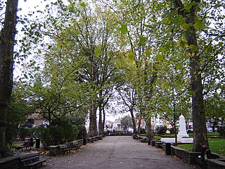
Islington Green is a small triangle of open land at the convergence of Upper Street and Essex Road in the London Borough of Islington. It roughly marks the northern boundary between the modern district of Angel and Islington proper.

Islington-City Centre West is a commercial and residential neighbourhood in Toronto, Ontario, Canada. One of four central business districts outside Downtown Toronto, it is bounded by Rathburn Road to the north, Islington Avenue to the east, Bloor Street to the south, Mimico Creek to the west.
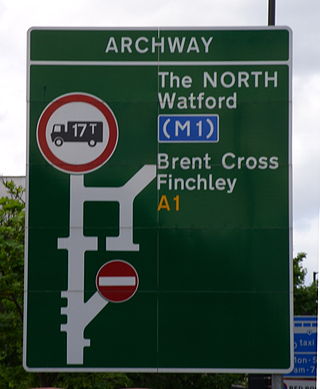
The A1 in London is the southern part of the A1 road. It starts at Aldersgate in the City of London, passing through the capital to Borehamwood on the northern fringe of Greater London, before continuing to Edinburgh. The road travels through the City and three London boroughs: Islington, Haringey and Barnet, which include the districts of Islington, Holloway, Highgate, Hendon and Mill Hill, and travels along Upper Street and Holloway Road, crossing the North Circular Road in Hendon, a district in the London Borough of Barnet.

Caledonian Road passes for about a mile and a half north–south through the London Borough of Islington. It connects North London, from Camden Road near its junction with Holloway Road, and central London's Pentonville Road in the south. It is known colloquially as the "Cally" and forms the entirety of the A5203.

The Angel is an area on the northern fringes of Central London within the London Borough of Islington. It is 2 miles (3.2 km) north-northeast of Charing Cross on the Inner Ring Road at a busy transport intersection. The area is identified in the London Plan as one of 35 major centres in London. It is a significant commercial and retail centre, and a business improvement district. The Angel straddles the ancient boundary of the parishes of Clerkenwell and Islington that later became the metropolitan boroughs of Finsbury and Islington. It is named from the former Angel Inn which stood on the corner of Islington High Street and Pentonville Road. Since 1965 the whole area has formed part of the London Borough of Islington in Greater London.

Highbury New Park is a street in Highbury in the London Borough of Islington which runs from Highbury Quadrant in the north to Highbury Grove in the south.

The Packington Estate is a large council estate in Islington, London.
References
- ↑ "North London Railway - Aberdeen Park". Edith's Streets. 10 February 2014. Retrieved 25 July 2019.
- ↑ Reading, Michael (2013). "Letters and your questions" (PDF). Journal of the Islington Archaeology & History Society. 3 (4 Winter 2013-14): 6–7.