
The Alpine orogeny or Alpide orogeny is an orogenic phase in the Late Mesozoic (Eoalpine) and the current Cenozoic that has formed the mountain ranges of the Alpide belt.
The Hercynian Forest was an ancient and dense forest that stretched across Western Central Europe, from Northeastern France to the Carpathian Mountains, including most of Southern Germany, however its boundaries are a matter of debate. It formed the northern boundary of that part of Europe known to writers of Antiquity. The ancient sources are equivocal about how far east it extended. Many agree that the Black Forest, which extended east from the Rhine valley, formed the western side of the Hercynian, except, for example, Lucius of Tongeren. According to him, it included many massifs west of the Rhine.

The Caledonian orogeny was a mountain-building era recorded in the northern parts of the British Isles, the Scandinavian Mountains, Svalbard, eastern Greenland and parts of north-central Europe. The Caledonian orogeny encompasses events that occurred from the Ordovician to Early Devonian, roughly 490–390 million years ago (Ma). It was caused by the closure of the Iapetus Ocean when the continents and terranes of Laurentia, Baltica and Avalonia collided.

The Variscan or Hercynianorogeny was a geologic mountain-building event caused by Late Paleozoic continental collision between Euramerica (Laurussia) and Gondwana to form the supercontinent of Pangaea.
Hercynia, provisional designation 1900 FK, is a background asteroid from the outer regions of the asteroid belt, approximately 38 kilometers in diameter. It was discovered on 21 September 1900, by astronomers Max Wolf and Arnold Schwassmann at the Heidelberg-Königstuhl State Observatory in southwest Germany. The asteroid was named for the ancient Hercynian Forest, known to the Romans as "Hercynia silva".
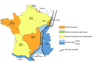
The Paris Basin is one of the major geological regions of France. It developed since the Triassic over remnant uplands of the Variscan orogeny. The sedimentary basin, no longer a single drainage basin, is a large sag in the craton, bordered by the Armorican Massif to the west, the Ardennes-Brabant axis to the north, the Massif des Vosges to the east, and the Massif Central to the south.

The Helvetic zone, Helvetic system or the Helveticum is a geologic subdivision of the Alps. The Helvetic zone crops out mainly in Switzerland, hence the name. Rocks in the Helvetic zone are sedimentary and were originally deposited at the southern margin of the European plate. The Helvetic zone correlates with the French Dauphinois zone, French geologists often prefer the French name but normally this is considered the same thing.
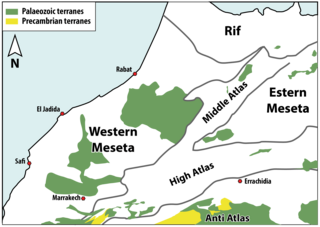
The Moroccan Meseta or Western Meseta, are uplifted terranes of dominantly Palaeozoic rocks exposed along the Moroccan coastal block between the Atlantic Margin and the Middle Atlas.
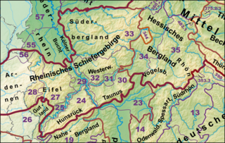
The Rhenish Massif, Rhine Massif or Rhenish Uplands is a geologic massif in western Germany, eastern Belgium, Luxembourg and northeastern France. It is drained centrally, south to north by the river Rhine and a few of its tributaries.
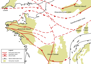
The Armorican Massif is a geologic massif that covers a large area in the northwest of France, including Brittany, the western part of Normandy and the Pays de la Loire. It is important because it is connected to Dover on the British side of the English Channel and there has been tilting back and forth that has controlled the geography on both sides.

The Rhenohercynian Zone or Rheno-Hercynian zone in structural geology describes a fold belt of west and central Europe, formed during the Hercynian orogeny. The zone consists of folded and thrust Devonian and early Carboniferous sedimentary rocks that were deposited in a back-arc basin along the southern margin of the then existing paleocontinent Laurussia.
The Saxothuringian Zone, Saxo-Thuringian zone or Saxothuringicum is in geology a structural or tectonic zone in the Hercynian or Variscan orogen of central and western Europe. Because rocks of Hercynian age are in most places covered by younger strata, the zone is not everywhere visible at the surface. Places where it crops out are the northern Bohemian Massif, the Spessart, the Odenwald, the northern parts of the Black Forest and Vosges and the southern part of the Taunus. West of the Vosges terranes on both sides of the English Channel are also seen as part of the zone, for example the Lizard complex in Cornwall or the Léon Zone of the Armorican Massif (Brittany).

The Mid-German Crystalline High is a structural high in the Paleozoic geology of Germany. The high forms a northeast-southwest oriented zone through Germany, but actual rock outcrops are sparse since Paleozoic basement rocks are in most of central Germany overlain by younger sedimentary rocks. The Mid-German Crystalline High crops out in the Odenwald, the Spessart, the northern Vosges and some small other massifs.
The Stavelot Massif is a geological massif in the Belgian Ardenne. Most of the massif crops out in Belgium, but a small part lies across the border with Germany.
The Bohemian Massif is a geomorphological province in Central Europe. It is a large massif stretching over most of the Czech Republic, eastern Germany, southern Poland and northern Austria.
The Gotthard nappe is, in the geology of the Alps a nappe in the Helvetic zone of Switzerland. It consists of crystalline rocks that were, before the formation of the Alps, part of the upper crust of the southern margin of the European continent. As it names suggests, the Gotthard nappe lies in close proximity to the Gotthard Massif.
The geology of Morocco formed beginning up to two billion years ago, in the Paleoproterozoic and potentially even earlier. It was affected by the Pan-African orogeny, although the later Hercynian orogeny produced fewer changes and left the Maseta Domain, a large area of remnant Paleozoic massifs. During the Paleozoic, extensive sedimentary deposits preserved marine fossils. Throughout the Mesozoic, the rifting apart of Pangaea to form the Atlantic Ocean created basins and fault blocks, which were blanketed in terrestrial and marine sediments—particularly as a major marine transgression flooded much of the region. In the Cenozoic, a microcontinent covered in sedimentary rocks from the Triassic and Cretaceous collided with northern Morocco, forming the Rif region. Morocco has extensive phosphate and salt reserves, as well as resources such as lead, zinc, copper and silver.
The geology of Belgium encompasses rocks, minerals and tectonic events stretching back more than 500 million years. Belgium covers an area of about 30,507 square kilometers and was instrumental in the development of geology. The extensive outcrops in Belgium became the standard reference points in stratigraphy as early as the mid-19th century. Some of them are internationally recognized features related to the Carboniferous and the Devonian periods. These rocks were folded by two orogeny mountain building events --the Hercynian orogeny, and Caledonian Orogeny. Paleozoic basement rocks cover much of the country and are overlain by Mesozoic and Cenozoic sediments.

The geology of Peru includes ancient Proterozoic rocks, Paleozoic and Mesozoic volcanic and sedimentary rocks, and numerous basins and the Andes Mountains formed in the Cenozoic.