
South San Francisco is a city in San Mateo County, California, United States, located on the San Francisco Peninsula in the San Francisco Bay Area. The city is colloquially known as “South City”. The population was 63,632 at the 2010 census.

The Duboce Triangle neighborhood is located near the center of San Francisco, California just below the hilly slopes of Buena Vista Park between the neighborhoods of the Castro/Eureka Valley, the Mission District, and the Lower Haight. The area is sometimes known as Mint Hill, after the United States Mint, nearby on a steep rocky cliff overlooking the intersection of Market and Duboce streets. The neighborhood is bordered by Market St., Castro St., and Duboce Avenue.

St. Francis Wood is a residential neighborhood located in southwestern San Francisco, California, south of the West Portal neighborhood and west of Mount Davidson. St. Francis Wood had a population of 1,228 and a median household income of $144,719 in 2013. Characterized by family homes on spacious lots, St. Francis Wood has no visible businesses and has a correspondingly low profile compared to similar wealthy neighborhoods such as the Marina District and Pacific Heights. St. Francis Wood is one of eight master-planned residence parks in San Francisco.

Haight Street is the principal street in San Francisco,'s Haight-Ashbury district, also known as the Upper Haight due to its elevation. The street stretches from Market Street, through the Lower Haight neighborhood, to Stanyan Street in the Upper Haight, at Golden Gate Park. In most blocks it is residential, but in the Upper and Lower Haight it is also a neighborhood shopping street, with residences above the ground floor shops. It is named after California pioneer and exchange banker Henry Haight (1820–1869).
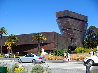
The Fine Arts Museums of San Francisco (FAMSF), comprising the de Young Museum in Golden Gate Park and the Legion of Honor in Lincoln Park, is the largest public arts institution in the city of San Francisco. The permanent collection of the Fine Arts Museums, with about 150,000 objects, is organized into nine areas, each with a curatorial staff.
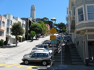
Filbert Street in San Francisco, California starts at Lyon Street on the east edge of The Presidio and runs east, crossing Van Ness Avenue and Columbus Avenue. It ends on Telegraph Hill at Kearny Street below Coit Tower and eventually resumes as a pedestrian stairway known as the Filbert Street Steps.

Mission Bay was a bay and the estuary of Mission Creek, on the west shore of San Francisco Bay, between Steamboat Point and Point San Quentin or Potrero Point. It is now mostly filled in and is the location of the Mission Bay neighborhood of San Francisco.

The Wave Organ is a sculpture constructed on the shore of San Francisco Bay in May 1986 by the Exploratorium, and more specifically, by Exploratorium artist in residence Peter Richards, who conceived and designed the organ, working with sculptor and mason George Gonzales.

The Oakland Estuary is the strait in the San Francisco Bay Area, California, separating the cities of Oakland and Alameda and the Alameda Island from the East Bay mainland. On its western end, it connects to San Francisco Bay proper, while its eastern end connects to San Leandro Bay.

Middle Harbor Shoreline Park (MHSP) is located on San Francisco Bay and the Port of Oakland entrance channel, west of downtown Oakland, California. It is owned and operated by the Port of Oakland. The park entrance is at the intersection of 7th Street and Middle Harbor Road. It is open seven days a week from 8 a.m. to dusk.

Hayward Regional Shoreline is a regional park located on the shores of the San Francisco Bay in Hayward, California. It is part of the East Bay Regional Parks system. The 1,713 acre park extends to the shores of San Lorenzo. Part of the park is former commercial salt flats purchased in 1996. A former landfill, now capped with soil and plants, is located in the park. The park includes the 250 acre tidal wetland, Cogswell Marsh, and the 364 acre Oro Loma Marsh. Located to the south of the park is the Hayward Shoreline Interpretive Center, which provides information on the Bay shore habitats. The San Francisco Bay Trail runs through the park, which connects the park with San Lorenzo Creek.

Quarry Lakes Regional Recreation Area is a regional park located in Fremont, California that is part of the East Bay Regional Parks system. Before being converted into a park, the site was used as a gravel quarry. When water purchased by the public for groundwater recharge of the Niles Cone flooded the gravel pits, the gravel harvesters began to daily pump the seeping water down Alameda Creek into San Francisco Bay. The Alameda County Water District acquired the quarry after the pumping was declared to be an illegal waste in 1976.
Hoffman Marsh is a wetlands on San Francisco Bay in Richmond, California. The marsh has been protected within Eastshore State Park, and adjacent to Point Isabel Regional Shoreline. The marsh is an important nesting ground for wildfowl and stopping ground on the Pacific Flyway, as it is one of only a handful of undestroyed wetlands in the Bay Area. It borders Point Isabel Regional Shoreline and Interstate 80.
19th Avenue in a north-south city street in San Francisco, California. It consists of two non-contiguous segments that are separated by Golden Gate Park. The southern segment is a six-lane arterial thoroughfare, mostly signed as part of California State Route 1, that goes through the southwestern part of the city. The non-contiguous northern segment is primarily a residential street through the Richmond District.

Recreation Park was the name applied to several former baseball parks in San Francisco, California in the late 19th century and early 20th century.

Año Nuevo State Marine Conservation Area (SMCA) is one of two adjoining marine protected areas off the coast of San Mateo and Santa Cruz Counties, on California’s central coast. The area is approximately 55 miles south of San Francisco. The SMCA is 11.07 square miles. Except for limited taking of giant kelp, all living marine resources are protected.

Designed to meet the needs of underserved Bayview-Hunters Point communities in southeast San Francisco, the EcoCenter at Heron's Head Park is a unique educational facility that combines environmental education, experience-based learning and habitat restoration. Located by the Bay in one of the last of San Francisco's wild landscapes, the EcoCenter is also a model for green building and sustainable resource use.

Greyhound Rock State Marine Conservation Area (SMCA) is one of two adjoining marine protected areas off the coast of San Mateo County and Santa Cruz County, on California's central coast. The area is approximately 55 miles (89 km) south of San Francisco. The SMCA is 11.81 square miles (30.6 km2). Within the SMCA fishing and take of all living marine resources is prohibited except the recreational take of giant kelp, squid, salmon, and other finfish, subject to various conditions. Also permitted is the commercial take of giant kelp, salmon, and squid, subject to various conditions.
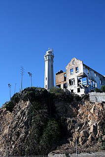
The Warden’s House was the home of the wardens of the federal penitentiary on Alcatraz Island, off San Francisco. It is located at the northeastern end of the Main Cellblock, next to Alcatraz Lighthouse. The 3-floor 15-room mansion was built in 1921 according to the Golden Gate National Recreational Area signpost, although some sources say it was built in 1926 or 1929 and had 17 or 18 rooms.
In Chan Kaajal Park is a public park in the Mission District of San Francisco, USA, located north of 17th Street between Folsom and Shotwell Street.