Hersfeld Tithe Register

Last updated
Hersfelder Tithe Register in a transcript from the 11th Century Hersfeld zehntverzeichniss.jpg
Hersfelder Tithe Register in a transcript from the 11th Century

The Hersfeld Tithe Register (German: Hersfelder Zehntverzeichnis) is a list of the places and castles in the Friesenfeld Gau (territory) and in Hassegau, from which Hersfeld Abbey received tithes. [1] The original document dates from between 881 and 887 or between 896 and 899, but no longer exists. [2] The list is found in a transcript from the 11th Century, which is now in the Hessischen Staatsarchiv Marburg. [3]

Contents

The tithe register is divided into four sections. Many placenames are duplicated and triplicated.

The first part was apparently compiled between 830 und 860, and lists under 239 numbers a large number of placenames. The second part and subsequent parts were created during the abbacy of Abbott Harderat between 889 and 899 and was bound with the first part and lists 18 names, each of which ends in '-burg' 2. In the third part 13 places are listed and in the fourth 5 markets and 7 places are listed. [4]

Many modern placenames in the modern day German states of Thuringia and Saxony-Anhalt can be connected with a corresponding name in the register. [5]

List of Places

"Haec est Decimatio quae pertinet ad sanctum Wigberthvm in Frisonoveld" (This the tithe which belongs to the blessed Wigbert in Friesenfeld) [4]

  1. [Al]bundesleba – Alvensleben, an abandoned village on the site of present-day Sangerhausen
  2. Rurbach – Rohrbach, a Cistercian monastery east of Oberöblingen
  3. Rebiningi – Oberröblingen
  4. Seobach – presumably Seebach, a burb of present-day Mühlhausen
  5. Enzinga – Einzingen, now a part of Allstedt
  6. RebiningiNiederröblingen (Helme)
  7. Gisilhus – Kieselhausen, an abandoned village to the west of present-day Sangerhausen.
  8. SangerhusSangerhausen
  9. [R]eotstat – Riestedt, now a part of Sangerhausen
  10. BurcdorpfBurgsdorf
  11. Niustat – possibly Nienstedt (now part of Allstedt)
  12. SuderhusaSotterhausen
  13. Niunburc(Beyer-)Naumburg
  14. Grabanesdorpf – Grabesdorf, abandoned village near Beyernaumburg
  15. Liobolvesdorpf – Lobesdorf, abandoned village near present-day Sotterhausen
  16. HoldestediHoldenstedt
  17. Sineswinidun – Schweinswende, an abandoned village near Bornstedt
  18. Hildiburgorod – Klosterrode, now a part of Blankenheim
  19. Liudolvesdorpf
  20. BrunistatBornstedt (bei Eisleben)
  21. Sidichenbechiu – Sittichenbach, now a part of Lutherstadt Eisleben
  22. Uuinidodorpf – Wenthdorf, abandoned village near Osterhausen
  23. OsterhusaGroß-Osterhausen
  24. Einesdorpf – Einsdorf, now part of Allstedt
  25. Midelhusa – Mittelhausen (Allstedt)
  26. WinchillaWinkel (Helme)
  27. UuolfheresstediWolferstedt
  28. Brallidesdorpf
  29. Hornum
  30. Nigendorpf – Klosternaundorf, now part of Allstedt
  31. OsterhusaKlein-Osterhausen
  32. Scrinbechiu – Rothenschirmbach, now part of Lutherstadt Eisleben
  33. HornbercHornburg, Saxony-Anhalt
  34. BisgofesdorpfBischofrode
  35. HardabrunnoErdeborn
  36. Dachendorpf – possibly a variant spelling for Neckendorf, Nachendorpf
  37. Helpide – Helfta, now part of Lutherstadt Eisleben
  38. LuzilendorpfLüttchendorf
  39. ScidingeBurgscheidungen
  1. Leobedigasdorpf – Lipsdorf
  2. Budinendorpf – Bündorf (Wüstung)
  3. Ziuuinidum – Wenden, now part of Mücheln
  4. Rozwalesdorpf – possibly Rulsdorf or Schwötzschdorf
  1. SeoburcSeeburg (Mansfelder Land)
  2. RostenlebaRoßleben
  3. AlberestatAlberstedt
  4. GuministiKunisch
  5. RebiningiUnterröblingen
  6. Budinendorpf – probably Bindorf
  1. AltstediAllstedt
  2. Meginrichesdorpf – probably Memleben or Weningenmemleben
  3. StediStedten (Mansfelder Land)
  4. BudilendorpfBottendorf (Roßleben-Wiehe)
  1. Bablide – Mönchpfiffel, now part of Mönchpfiffel-Nikolausrieth
  2. MimilebaMemleben or Weningenmemleben
  3. OsperestatEsperstedt (Obhausen)
  4. Miscawe – vermutlich Meuschau
  1. Eindorf – vielleicht Einsdorf
  2. Odesfurt – Oßfurt
  3. ScrabanlochSchraplau
  4. GerburgoburcKorbesberg
  5. Wangen[Klein-]Wangen
  6. Wodina
  7. Dachendorpf
  8. HeiendorpfHayndorf
  9. Fizinburc – Vitzenburg, since 2004 a part of Querfurt
  10. ScidingaKirchscheidungen

Castles

„Haec sunt urbes que cum viculis suis et omnibus locis ad se perti[nentibus] decimationes dare debent ad sanctum Wigberhdym ad Herolvesfeld“ (These are the castles with their farmsteads and all localities which must give tithes to the blessed Wigbert in Herodsfeld)

  1. Helphideburc – Helfta Castle, now part of Lutherstadt Eisleben
  2. NiuuenburgBeyernaumburg
  3. AltstediburgAllstedt Castle
  4. MerseburgMerseburg
  5. ScrabenlebaburgSchraplau
  6. Bru[nstedibur]g- Bornstedt, Schweinsburg
  7. SeoburgSeeburg
  8. Gerburgoburg – Korbesberg
  9. Vizenburg – Vitzenburg Castle in Querfurt
  10. CurnfurdeburgQuerfurt Castle
  11. ScidingeburgBurgscheidungen Castle
  12. UuirbineburgBurgwerben
  13. MuchileburgMücheln
  14. GozzesburgGoseck
  15. Cucunburg – Kuckenburg, now part of Esperstedt
  16. Liudineburg – Lettin, now part of Halle (Saale)
  17. H[unlebab]urg – Holleben, now part of Teutschenthal
  18. Vuirbinaburg – eventuell Markwerben
  19. Suemeburg – eventuell Schanze bei Korbetha-Wengelsdorf oder eine unbenannte Anlage bei Kraßlau/Leina

Literature

Related Research Articles

<span class="mw-page-title-main">Province of Saxony</span> Province of the Kingdom of Prussia

The Province of Saxony, also known as Prussian Saxony, was a province of the Kingdom of Prussia and later the Free State of Prussia from 1816 until 1944. Its capital was Magdeburg.

<span class="mw-page-title-main">Sangerhausen</span> Town in Saxony-Anhalt, Germany

Sangerhausen is a town in Saxony-Anhalt, central Germany, capital of the district of Mansfeld-Südharz. It is situated southeast of the Harz, approx. 35 kilometres east of Nordhausen, and 50 km (31 mi) west of Halle (Saale). About 26,000 people live in Sangerhausen (2020).

Ulrich Willerding is a professor emeritus of botany at the Göttingen University, Germany. He is also an instructor at a local high school. Willerding is one of the leading European palaeo-ethnobotanists. He has specialized in Medieval Europe but also done work on other times. One of his special interests is weeds. He has worked on bibliographies of European paleoethnobotany. Although a biologist by training, he has worked extensively with archaeologists.

<span class="mw-page-title-main">Christian Ludwig Nitzsch</span>

Christian Ludwig Nitzsch was a German zoologist. He is best remembered for his approach to classifying birds on the basis of their feather tract distributions or pterylosis of their young.

<span class="mw-page-title-main">Mansfeld</span> Town in Saxony-Anhalt, Germany

Mansfeld, sometimes also unofficially Mansfeld-Lutherstadt, is a town in the district of Mansfeld-Südharz, in Saxony-Anhalt, Germany.

<span class="mw-page-title-main">Bad Bocklet</span> Municipality in Bavaria, Germany

Bad Bocklet is a municipality in the district of Bad Kissingen in Bavaria in Germany. It is a market town and a health spa.

Ebersroda is a village and a former municipality in the Burgenlandkreis district, in Saxony-Anhalt, Germany. Since 1 July 2009, it is part of the municipality Gleina.

Röblingen am See is a village and a former municipality in the Mansfeld-Südharz district, Saxony-Anhalt, Germany. Since 1 January 2010, it is part of the municipality Seegebiet Mansfelder Land, of which it is the administrative centre.

<span class="mw-page-title-main">Mönchpfiffel-Nikolausrieth</span> Municipality in Thuringia, Germany

Mönchpfiffel-Nikolausrieth is a municipality on the river Helme in the district Kyffhäuserkreis, in Thuringia, Germany. The municipality was created in 1956 by the merging of the villages Monchpfiffel and Nikolausrieth.

Matilda, also known as Mathilda and Mathilde, was a German regent, and the first Princess-Abbess of Quedlinburg. She served as regent of Germany for her brother during his absence in 967, and as regent during the minority of her nephew from 984.

<span class="mw-page-title-main">Helme (river)</span> River in Germany

The Helme is a river in central Germany that is about 65 kilometres (40 mi) long and which forms a left-hand, western tributary of the Unstrut in the states of Thuringia and Saxony-Anhalt.

Mansfeld Land is a region in the southwestern corner of the German state of Saxony-Anhalt. The region derives its name from the counts of Mansfeld, who ruled this region for about 1,000 years.

<span class="mw-page-title-main">Teltow and Magdeburg Wars</span>

The Teltow and Magdeburg Wars were fought between 1239 and 1245 over possession of Barnim and Teltow in the present-day federal German state of Brandenburg. They took place in the 13th century during the course of the Eastern German Expansion. The opposing sides during the armed conflict, which took place on two fronts simultaneously, were:

<span class="mw-page-title-main">Heinrich August Erhard</span> German physician, archivist and historian

Heinrich August Erhard was a German physician, archivist and historian.

<span class="mw-page-title-main">Fischberg Castle</span>

Fischberg Castle was a high medieval fortification in the Felda valley that was sited on an exposed hill above the villages of Klings, Fischbach and Diedorf. Its ruins currently stand in the county of Wartburgkreis (Thuringia) - in the Anterior Rhön, part of a mountain region in central Germany.

<span class="mw-page-title-main">Friesenfeld</span>

The Friesenfeld was a Gau (territory), in modern-day north Thuringia and south Saxony-Anhalt in the area between Allstedt and Merseburg and which bordered Hassegau. Numerous places in Friesenfeld such as Erdeborn were named in the Hersfeld Tithe Register of the Hersfeld Abbey as being obliged to pay tithes.

<span class="mw-page-title-main">Johannisberg (Jena-Lobeda)</span> Johannisberg is a prominent ridge of the Wöllmisse

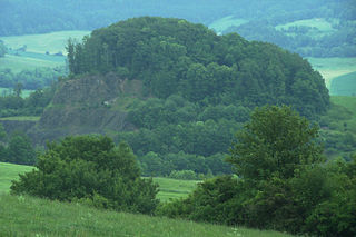
Johannisberg is a prominent ridge of the Wöllmisse, a Muschelkalk plateau east of Jena. The steeply sloping spur of land to the Saale Valley north of the district of Alt-Lobeda bears the remains of two important fortifications from the late Bronze Age and the early Middle Ages. Due to several archaeological excavations and finds recovered since the 1870s, they are among the few investigated fortifications from these periods in Thuringia. Of particular interest in archaeological and historical research is the early medieval castle. Due to its location directly on the eastern bank of the Saale, its dating and interpretation were and are strongly linked to considerations of the political-military eastern border of the Frankish empire. It is disputed whether it was a fortification of independent Slavic rulers or whether it was built under Frankish rule. According to a recent study, it may have been built in the second half of the 9th century in connection with the establishment of the limes sorabicus under Frankish influence.

<span class="mw-page-title-main">Mistislaw</span> Elbe Slavic prince of the Nakonid family

Mistislaw, also known as Mstislav, was an Elbe Slavic prince of the Nakonid lineage and ruled over the Obotrites in what is now Mecklenburg and eastern Holstein from 990/995 to 1018.

References

  1. Zschieschang, Christian (November 4, 2017). Das Hersfelder Zehntverzeichnis und die frühmittelalterliche Grenzsituation an der mittleren Saale: Eine namenkundliche Studie. Böhlau Verlag Köln Weimar. ISBN   9783412507213 via Google Books.
  2. Bernhardt, John W. (August 22, 2002). Itinerant Kingship and Royal Monasteries in Early Medieval Germany, C.936-1075. Cambridge University Press. ISBN   9780521521833 via Google Books.
  3. "Detail page - Archivportal-D". www.archivportal-d.de.
  4. 1 2 Zschieschang, Christian (November 4, 2017). Das Hersfelder Zehntverzeichnis und die frühmittelalterliche Grenzsituation an der mittleren Saale: Eine namenkundliche Studie. Böhlau Verlag Köln Weimar. ISBN   9783412507213 via Google Books.
  5. "More Than 1000 Years of History". www.burg-querfurt.de.