San Antonio, officially the City of San Antonio, is a city in the U.S. state of Texas and the most populous city in Greater San Antonio, the third-largest metropolitan area in Texas and the 24th-largest metropolitan area in the United States at 2.6 million people in 2020. It is the most populous city in and seat of Bexar County. The city is the seventh-most populous in the United States, the second-largest in the Southern United States, and the second-most populous in Texas after Houston.
Wilson County is a county located in the U.S. state of Texas. As of the 2020 census, its population was 49,753. Its county seat is Floresville. The county is named after James Charles Wilson. Wilson County is part of the San Antonio–New Braunfels, Texas, metropolitan statistical area.

Houston County is a county located in the U.S. state of Texas. As of the 2020 census, its population was 22,066. Its county seat is Crockett. Houston County was one of 46 entirely dry counties in the state of Texas, until voters in a November 2007 special election legalized the sale of alcohol in the county.

Bexar County is a county in the U.S. state of Texas. It is in South Texas and its county seat is San Antonio.

Schertz is a city in Guadalupe, Bexar, and Comal counties in the U.S. state of Texas, within the San Antonio–New Braunfels metropolitan area. The population was 42,002 at the 2020 census, up from 31,465 at the 2010 census. Schertz was settled by Alsatian emigrants in the 1800s.

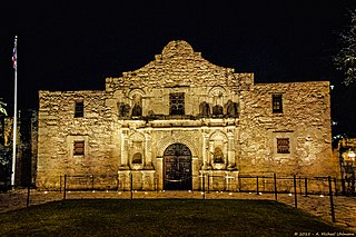
The Daughters of the Republic of Texas (DRT) is a lineal association dedicated to perpetuating the memory of the founding families and soldiers of the Republic of Texas. The Daughters of the Republic of Texas is best known for its former role as caretakers of The Alamo. In early 2015, Texas Land Commissioner George P. Bush officially removed control of the Alamo to the Texas General Land Office. The DRT were also the custodians of the historic French Legation Museum until 2017, which is owned by the State of Texas and is now operated by the Texas Historical Commission. In addition, they operate a museum in Austin on the history of Texas.

Whataburger is an American regional fast food restaurant chain, headquartered and based in San Antonio, Texas, that specializes in hamburgers. Founded by Harmon Dobson and Paul Burton, it opened its first restaurant in Corpus Christi, Texas in 1950. Family-owned by the Dobsons until 2019, the chain is now managed by the private equity firm BDT & MSD Partners; the Dobson family still holds a small stake.
Fort Sam Houston is a U.S. Army post in San Antonio, Texas. Known colloquially as "Fort Sam," it is named for the U.S. Senator from Texas, U.S. Representative from Tennessee, Tennessee and Texas governor, and first president of the Republic of Texas, Sam Houston.
The Missouri–Kansas–Texas Railroad was a Class I railroad company in the United States, with its last headquarters in Dallas, Texas. Established in 1865 under the name Union Pacific Railroad (UP), Southern Branch, it came to serve an extensive rail network in Texas, Oklahoma, Kansas, and Missouri. In 1988, it merged with the Missouri Pacific Railroad; today, it is part of UP.

The San Antonio River Walk is a city park and special-case pedestrian street in San Antonio, Texas, one level down from the automobile street. The River Walk winds and loops under bridges as two parallel sidewalks lined with restaurants and shops, connecting the major tourist draws such as the Shops at Rivercenter, the Arneson River Theatre, Marriage Island, La Villita, HemisFair Park, the Tower Life Building, the San Antonio Museum of Art, the Pearl, and the city's five Spanish colonial missions, which have been named a World Heritage Site, which includes the Alamo. During the annual springtime Fiesta San Antonio, the River Parade features flowery floats that float down the river.

Buffalo Bayou is a slow-moving body of water which flows through Houston in Harris County, Texas. Formed 18,000 years ago, it has its source in the prairie surrounding Katy, Fort Bend County, and flows approximately 53 miles (85 km) east through the Houston Ship Channel into Galveston Bay and the Gulf of Mexico. In addition to drainage water impounded and released by the Addicks and Barker reservoirs, the bayou is fed by natural springs, surface runoff, and several significant tributary bayous, including White Oak Bayou, Greens Bayou, and Brays Bayou. Additionally, Buffalo Bayou is considered a tidal river downstream of a point 440 yards (400 m) west of the Shepherd Drive bridge in west-central Houston.

Brooke Army Medical Center (BAMC) is the United States Army's premier medical institution. Located on Fort Sam Houston, BAMC, a 425-bed Academic Medical Center, is the Department of Defense's largest facility and only Level 1 Trauma Center. BAMC is also home to the Center for the Intrepid, an outpatient rehabilitation facility. The center is composed of ten separate organizations, including community medical clinics, centered around the Army's largest in-patient hospital. BAMC is staffed by more than 8,000 Soldiers, Airmen, Sailors, Civilians, and Contractors providing care to wounded Service Members and the San Antonio Community at-large.
The San Antonio Public Library (SAPL) is the public library system serving the city of San Antonio, Texas. It consists of a central library, 29 branch libraries, and a library portal. SAPL was awarded the National Medal for Museum and Library Service in 2006.

The Henry B. González Convention Center is the City of San Antonio's convention center located in Downtown San Antonio, Texas, along the banks of the River Walk.

Artpace is a non-profit contemporary art foundation located in downtown San Antonio, Texas that is free and open to the public. Founded by artist, collector, and philanthropist Linda Pace, Artpace opened its doors in 1995, and focuses on nurturing the creative and artistic processes of both established and emerging artists. Fostering opportunities for dialogue and social interactions between artists and community members of all ages has always been central to the various programs at Artpace.

Greater San Antonio, officially designated San Antonio–New Braunfels, is an eight-county metropolitan area in the U.S. state of Texas defined by the Office of Management and Budget (OMB). The metropolitan area straddles South Texas and Central Texas and is on the southwestern corner of the Texas Triangle. The official 2020 U.S. census showed the metropolitan area's population at 2,558,143—up from a reported 1,711,103 in 2000—making it the 24th largest metropolitan area in the United States. Downtown Austin and Downtown San Antonio are approximately 80 miles (129 km) apart, and both fall along the Interstate 35 corridor. This combined metropolitan region of San Antonio–Austin has approximately 5 million people.

Downtown San Antonio is the central business district of San Antonio, Texas and the urban core of Greater San Antonio, a metropolitan area with nearly 2.5 million people.

The Sporting District was a red-light district in the U.S. city of San Antonio, Texas in the late 19th and early 20th centuries. It was established by the city council to manage prostitution in the city. For a time it was one of the nation's largest vice districts with venues ranging from brothels to gambling halls. The area was officially shut down in 1941 resulting from the mobilization for World War II.

The following is a timeline of the history of the city of San Antonio, Texas, United States.
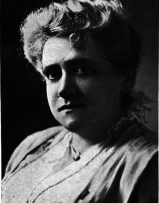
Anna Goodman Hertzberg was an American clubwoman who served as the co-founder of an all-women's chamber music society, the first women's music association in Texas.
