Hesselbach Castle

Last updated

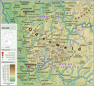
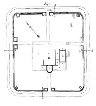
Hesselbach Castle was originally a Roman fortress of the older Odenwald line of the Neckar-Odenwald Limes. The present-day archaeological site is located in the area of Hesselbach, a district of the city of Oberzent in Odenwaldkreis, Germany. The former fortification is the most thoroughly researched military camp of the Odenwald Limes and the southernmost Limes fortress in Hesse. The Hesselbach fortress serves as a "reference fortress" for almost all other military camps of the Odenwald Limes; the insights gained here are used in Provincial Roman Archaeology to interpret the entire Limes section between the Main and Neckar rivers.

Contents

Location

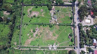
The former Hesselbach Fortress is located on the northeastern outskirts of Hesselbach, on an area used as meadows, on the eastern edge of the village, not far from the present-day Hessian-Bavarian state border. Modern roads run in front of its frontal side and flanks, and the rear side connects to the courtyard and pasture land of an agricultural enterprise. The contours of the former fortification are clearly visible in the terrain.

Topographically, the fortress is situated at 489 meters above sea level on the plateau of a ridge, which extends from the mouth of the Mümling River near Obernburg to the area around Schloßau in the southeast. The plateau, with its nutrient-poor weathered sandstone soils in a relatively harsh climate, did not and do not provide the best conditions for human settlements. However, the sandstone ridge runs parallel to the Mümling at a relatively consistent elevation, which likely made it a suitable border line. Pre-Roman finds are lacking in this area, and the Roman archaeological material also suggests a purely military, at best very short-term civilian, post-fortress use of the site. [1]

History and Significance

The Hesselbach Fortress was briefly mentioned by Ernst Christian Hansselmann (1699–1776) in 1768. A more detailed description was provided half a century later by Johann Friedrich Knapp (1776–1848), [2] who investigated the Odenwald Limes on behalf of Count Franz, Count of Erbach-Erbach. The Hessian Limes Commission likely conducted only superficial investigations of the fortress area, questioning the identification of the findings with a fortress at all, as only solid masonry could be proven at one location. [3] In 1895, excavations were conducted by the Imperial Limes Commission under the direction of the route commissioner Friedrich Kofler. The results were published in 1896. [4]

In 1961, the provincial Roman archaeologist Dietwulf Baatz visited the Tripolitanian Limes fortress of Gholaia to study constructive details of preserved Roman fortress gates. [5] Analogously, he applied his observations to graphic reconstructions of the gate structures at the Hesselbach Fortress. [6] Baatz subsequently took scientific leadership of extensive investigations with the then-most modern methods when Hesselbach was excavated from 1966 to 1968 by the Saalburg Museum. These excavations, along with the resulting publication, were groundbreaking for further research on the Odenwald Limes. [7] Since the excavation campaign of the 1960s, the Hesselbach Fortress has been considered the most thoroughly researched numerus fortress of the Odenwald Limes, mainly because, unlike other Odenwald fortresses, the interior layout could be extensively explored and documented. The interior layout of the other numerus fortresses of the Odenwald line has since often been reconstructed analogously to that of the Hesselbach Fortress. [7]

Findings

While the excavations of the Imperial Limes Commission at the end of the 19th century primarily focused on the fortification of the fortress, the emphasis of the 1960s investigations was on the exploration of the interior. In both sets of findings, several construction phases could be differentiated from each other. Since no secure stratigraphic connection could be established between the periods of fortification and the phases of the interior structures, different designations were chosen. [8] However, it is permissible to establish correlations between them based on the findings and the distribution of the archaeological material. [9]

Temporal correlations between the construction phases of the fortification and the interior structures. [9]

Development of the construction phases 1 to 3 (first wooden tower, second wooden tower, stone tower) 200910071049MEZ Odenwaldlimes Entwicklungsstufen (Tafel 10-11).jpg
Development of the construction phases 1 to 3 (first wooden tower, second wooden tower, stone tower)

Fortification A is from Period 1, lasting from Trajanic times until approximately 115–130. Fortification B is from Period 2, lasting from approximately 115–130 to approximately 145. Fortification C is from Period 2a, lasting from approximately 145 to somewhere between 148–161. Partially destroyed Fortification C is from Period 3 (the post-fortress period), lasting from approximately 148–161, at the latest 165.

Fortifications

The shape and extent (and thus the enclosed area) of the fortification facilities of the Hesselbach Fortress did not undergo and major changes during the various construction phases. The different walls lay almost on top of each other. The entire area defined by the fortifications of the fortress occupied an area of around 6,000 square meters at all times. The main gate (Porta praetoria) of the fortification was oriented towards the Limes, which passed the fortress about 150 meters eastward. It is noteworthy that the right side gate, and not the main gate had the widest passage width, indicating that this side gate assumed the function of a "main gate." The contours of the fortress fortification are still clearly visible in the largely unbuilt meadow area, with the modern path running around the outside of the fortress. An information board with explanations can be found in the north of the fortress. [10]

Fortification A

Reconstruction of a wooden tower Holzturm Typ.jpg
Reconstruction of a wooden tower

The oldest "Fortification A" was constructed together with the fortress during Trajanic times and was entirely built in wood and earth construction. The wooden palisade was reinforced towards the interior of the camp with an earth rampart supported by wooden stakes, which simultaneously served the function of carrying a simple walkway. In front of this wood and earth wall, there was a pointed ditch in the form of a so-called fossa Punica ("Punic ditch"), following a narrow berm. The side of the ditch facing the enemy was noticeably steeper than the side facing the camp. In this early phase, the fortification had only three gates: besides the main gate, there was a right side gate (Porta principalis dextra) and a left side gate (Porta principalis sinistra). The rear gate (Porta decumana) was missing and could not be confirmed in the form of a reduced gate. The gates were flanked by wooden gate towers, each supported by six posts. All evidence suggests the absence of corner towers, although it cannot be definitively concluded that they didn't exist. [11]

Fortification B

Reconstruction of a stone tower Odenwaldlimes Steinturm Typ.jpg
Reconstruction of a stone tower

In Hadrianic times, specifically between 115 and 130 CE, the wooden fortification was replaced by a two-layer dry stone wall construction. This construction, called "Fortification B," had a total width of 5 to 6.9 meters. The space between the outer wall, which was up to 1.5 meters wide, and the slightly narrower inner wall was filled with earth interspersed with timber stakes. The walls were made of uncut local sandstone. The construction possibly supported a walkway, possibly fixed with wooden planks, and on the enemy side, a battlement made of boards or wickerwork. The punic ditch, created in phase A, continued to serve as a defensive ditch but had been partially filled in over the years, losing its main purpose. The wooden gate structures were also retained. The camp still had only these three gates. [12]

Fortification C

Between 140 and 150 CE, the dry stone wall was replaced with a mortared wall. The new fortification wall followed the course of the old "Fortification B", being erected in front of its outer wall. Only at isolated points did the front of the older wall intersect with the new construction. Behind the wall, an earth rampart was piled up, which was not completely sloped towards the interior of the camp, but utilized the inner shell of the dry stone wall as a supporting boundary. The foundation of the wall was dug 80 centimeters deep and had a width fluctuating between 1 and 1.2 meters, with the thickness of the elevation at the base of the wall being around 95 centimeters. Local sandstone was used as the building material, mortared with lime mortar sourced from nearby Muschelkalk deposits in the Odenwald. The stones on the inside were small and roughly hewn, while the blocks on the outside were larger and meticulously executed. It is assumed that the outer wall above the battlement was equipped with battlements. The originally present white exterior plaster, usually painted over with red false joints, could no longer be identified. It likely eroded completely in the acidic soil of Hesselbach. [13]

Elevation Drawing of a Wooden and a Stone Tower in Comparison 200910071049MEZ Odenwaldlimes Wachturmschema (Tafel 10-11).jpg
Elevation Drawing of a Wooden and a Stone Tower in Comparison

As part of the new wall construction, the defense ditch, which had been at least partially silted up by this point, was replaced with a new one. It was set off from the wall by a 60 to 80-centimeter-wide berm and had a width of about six meters at a depth of around 1.5 meters. It is assumed that this ditch was designed in a ratio of five Roman feet to 20 Roman feet. [14]

The gates were also rebuilt from scratch. In addition to the existing three large gate structures, a small postern gate was added on the decumanus side (rear side of the fortress). The large gates were still flanked by two towers, likely not only connected by simple defensive platforms but also by covered gatehouses. This is supported by the fact that there were not only strong arches on the enemy side but also on the inside. While such arches might be necessary on the outside for fortification reasons, they only make sense on the inside for structural reasons. The clear passage width was 3.4 meters for the right side gate and three meters for both the main gate and the right side gate. The new rear postern gate, which was also found in the same form at the Würzberg and Eulbach forts, was a simple gate with a clear passage of only 1.25 meters, possibly secured by a barrier beam. The ditch alignment was uninterrupted in front of the gate, and a posthole indicated a possible wooden bridge at this point.

Even in this construction phase, there were no corner towers. However, the rounded corners of the wall were provided on the outside with slightly protruding risalits. This inexplicable characteristic of the wall construction is also found at the Oberscheidental fortress. [15]

Interior Layout

The interior buildings consisted of the central headquarters building (Principia), four barracks for the soldiers (Contubernia) with their quarters, the commander's residence (Praetorium), as well as warehouses and stables throughout all periods of the fortress. The presence of the Principia indicates that a tactically independent unit was stationed there, a Numerus with a garrison strength of approximately 160 men. In the commander's residence, the front section of the camp, stables and warehouses were accommodated. As customary in Roman military camps, the central headquarters building dominated the center. In the rear camp area, immediately behind the central headquarters building, was the commander's residence and - flanking the Principia - two barracks on each side. All buildings were made of wood, making them identifiable only by the discoloration of their post trenches and holes, a circumstance that the early excavators were not sufficiently familiar with, so with the excavation techniques of that time, hardly any findings of the interior buildings could be recorded.

Period 1

The Principia, the headquarters and administrative building (also referred to as "Building 5" in publications about Hesselbach) covered an area of approximately 10.5/10.8 meters by 18.0/18.2 meters in this period, including the forecourt, totaling slightly less than 200 square meters. However, imprecise construction and unclear, partly disturbed findings make it difficult to assign truly exact dimensions. The building was possibly originally designed to be 36 by 45 Roman feet in size. The Principia was entered through an open forecourt measuring approximately 4.2/4.4 meters by 10.7 meters. This hall covered the Via principalis (main camp street, which connected the two lateral camp gates) and opened with its front towards the Via praetoria (front main camp street) and the Porta praetoria (front camp gate, main gate). Alongside the Principia of the Künzing fortress, the commandant's office of Hesselbach is one of the oldest headquarters buildings with a forecourt. A courtyard lined with two porticos adjoined the forecourt, leading to a transverse hall (Basilica). The transverse hall (and thus the entire building complex) was closed off at its rear by a building consisting of three rooms. The middle, slightly larger of these rooms was the "sacred precinct" (Aedes principiorum or Sacellum), while the other two presumably served as administrative offices. [16]

Behind the Principia, in the middle of the Retentura (rear camp area), was the residence of the Praepositus Numeri, the commander (Praepositus) of the garrison ("Building 6"). Its outer dimensions were approximately 10.5 by 15 meters (just over 150 square meters), presumably designed with dimensions of 35 by 50 Roman feet. The entrance of the commander's building opened towards the Principia. The entrance possibly led into a cross-shaped corridor, in the center of which there may have been an atrium or atrium-like structure with skylights. In this case, there would have been six roughly equal-sized rooms and a smaller room (possibly a latrine) in the building. However, another interpretation of the findings also suggests a long, stretched central corridor, flanked on each long side by four separate rooms, with a smaller room at its end. A confirmed hearth indicates that at least some rooms in the building were heated. [17]

The Principia and commander's residence were flanked by two barracks each ("Buildings 1 to 4"). The four barracks measured approximately 34.6 meters by 4.55 meters (exterior) and were divided into nine roughly equal-sized rooms of about 3.7 by 4.15 meters clear width, resulting in a usable area of 15.5 square meters per room. There was no enlarged room or a head building for the non-commissioned officer. A portico could not be confirmed, but its existence cannot be entirely ruled out. Dietwulf Baatz assumed in his studies that each Contubernium was likely occupied by four to five soldiers, so if a room for the non-commissioned officer was deducted and the possible lower occupancy density of some rooms, where sergeants may have been accommodated, were considered, it could be assumed that each barrack housed around 32 men. This would result in a barracks occupancy of around 128 soldiers, so including non-commissioned officers and officers, a total strength of 130 to 140 men could be assumed. However, Baatz emphasized the hypothetical nature of his considerations, which were intended only to provide an approximate idea of the strength of the Numerus fortress. [16]

In the Praetentura, the front part of the camp, a total of three larger buildings were identified. The interpretation of the findings is not entirely clear due to the extensive soil erosion in this area. "Building 7" in the southeastern area of the fortress is interpreted as a storage building or warehouse, possibly including the armamentaria (weapon storage rooms) missing in the Principia. The two buildings, measuring 4.3 by 10.6 meters and 4.3 by 13.5 meters respectively, located in the northwest of the camp (Buildings 8 and 9), were likely identified as stables, with a possible bakery located in front of them. [18]

All buildings of Period 1 were constructed in wood. Repairs and damages could not be detected at any point; the buildings were apparently systematically dismantled before they deteriorated, presumably to make space for the construction of new buildings. [19]

Period 2

The structure of the fort in Period 2 corresponded roughly to the layout of Period 1. The construction technique was largely identical, although stronger wooden posts were used. The buildings were in use until the need for repair measures arose. The phase of maintenance measures that then began is differentiated as Period 2a.

The layout of the Principia (referred to as "Building 5") in this period resembled that of Period 1, but the portico extended laterally beyond the two alignments of the rest of the building complex by slightly more than one meter each. The hall had a width of 6.3 to 6.4 meters and a length of about 14.3 meters, constructed in an open manner and covering the entire width of the Via Principalis. From the portico, one entered a small courtyard, 3.8 meters wide and 7.7 meters long, which was flanked on its narrow sides by porticos 1.8 meters deep. The courtyard was followed by a transverse hall with a clear width of 6.9 meters and a length of 11.5 meters. The most striking difference from the layout of Period 1 was the variation in proportions between the courtyard with its porticos and the transverse hall, where the space for the courtyard was reduced in favor of the hall. A notable feature within the transverse hall was the identification of a cistern measuring almost 1.5 meters in diameter with a channelized drain towards the rear of the fort. This water was presumably needed for ritual purposes conducted in the Principia. Following the transverse hall, which concluded the rearward part of the building complex, as in Period 1, was a three-room suite. The middle, slightly larger room served as the shrine (Aedes or Sacellum), which unlike in Period 1, projected slightly outward from the rear wall of the Principia. This projection was reduced in the repair Period 2a, resulting in a uniform rear facade of the building complex. The cellar, often found in shrines, could not be identified for the second construction phase in Hesselbach, just as in the first phase, and appeared unlikely due to the soil conditions (waterlogging). [20]

"Building 6," the presumed residence of the Praepositus Numeri, had external dimensions of approximately 11.7 by 10.8 meters. It was a corridor house with a central corridor flanked by three rooms on each side. All six rooms were approximately 15 square meters in size, with at least four of them equipped with hearths. The building was oriented towards the Principia with its main entrance. A second entrance on the opposite side cannot be ruled out, but this area was disrupted by a modern pit. Possibly, a latrine could have been located at this end of the corridor. [21]

As in Period 1, the ensemble of Principia and Commandant's residence was flanked on each side by two barracks ("Buildings 1 to 4"). Unlike the early construction phase, these had both head buildings and porticos.

One building, "Barrack 4," was in particularly good condition. It extended with a width (including the portico) between 7.3 and 7.45 meters over a length of 34.8 meters, consisting of a series of seven contubernia with a front portico and a head building for the centurion and/or the non-commissioned officers. The clear width of the portico ranged between 1.6 and 1.7 meters. Of the total length, 27.4 meters were allocated to the seven contubernia, each likely having a useful area of slightly more than 19 square meters. Each contubernium consisted of a single, undivided room with a hearth located approximately in the middle of the dividing wall to a neighboring contubernium. The hearths resembled the appearance of common open fireplaces today: behind a fire-resistant floor plate was a smoke outlet, and above the hearth was a smokestack. The hearths were used for meal preparation and heating during the colder seasons. The head building of "Barrack 4" had an almost square footprint of approximately 7.4 meters on each side, resulting in a total living area of 53 square meters. It consisted (as a continuation of the portico) of a corridor and two rooms, each equipped with a hearth. Each pair of barracks (1 and 2, as well as 3 and 4) formed a barrack pair, with a gravel path running through the middle. The individual barracks differed in some features regarding shape and size. [22]

"Barrack 3" was noticeably narrower than "Barrack 4" and had no head building, but consisted of nine approximately equal-sized contubernia, each with approximately 12.5 square meters of floor space. "Barrack 2" had an unusually large head building with a total of three rooms and a side corridor branching off from the main corridor. Latrines with drainage channels were found in the head buildings of "Barracks 1 and 2." A similar latrine is presumed for the head building of "Barrack 4," although the area suitable for this was disturbed by a modern pit, so the corresponding archaeological evidence could not be provided. [23]

The eastern half of the Praetentura, the front part of the camp, was entirely occupied by the so-called "Building 7." This was a complex, possibly multi-phase structure with irregular room divisions. With external dimensions of approximately 20.8 by 13.1 meters, the building covered an area of around 270 square meters and had two entrances. Since the Retentura (rear part of the camp) was fully occupied by the Principia, the Praetorium, and the four barracks, and therefore the Horreum (storehouse) and Armamentaria (armory) could not be located there, Dietwulf Baatz interpreted this finding as a "multi-purpose building" that combined the functions of a storehouse and armory under one roof. According to the archaeologist, this was supported by the location of this building immediately adjacent to the Porta principalis dextra, apparently serving as the main gate. [24]

In the western part of the Praetentura, traces of the foundations of two simple buildings, not further subdivided internally, were identified. Both buildings had an elongated rectangular shape. The "Building 8," facing the Via Praetoria, was 14.6 meters long and 4.0 meters wide, while the "Building 9," facing the fortification, was 14.3 meters long and 5.3 meters wide. Analogous to the findings of Period 1, these two structures were interpreted as stables, supported by the observation of water containers outside the buildings and troughs that could have served to supply the livestock with fresh water and/or dispose of manure. The function of another "Building 10," a simple shed approximately 8.0 by 2.8 meters in size, located at the site where a bakery group was assumed for Period 1, could not be clarified. [25]

The camp roads were made of multi-layered gravel without a pavement of larger stones and without curbstones. The method of providing the camp with fresh water is unclear. The fact that no wells were found inside the fort does not necessarily rule out their existence, as the entire fort area was not fully excavated. However, traces of water containers and channels rather suggest a supply of running water, possibly from an area approximately 250 to 300 meters northeast of the fort, where springs still emerge from the wet meadows today. This perhaps insufficient supply of fresh water may have been supplemented by rainwater collected from the roofs. The sewage disposal system, on the other hand, is better understood. It was carried out through several smaller channels leading into a larger collecting trench, which ultimately led out of the fort next to the Porta decumana into a defensive ditch. This is also where the camp's latrines are presumed to have been, which could have been flushed with the draining wastewater. However, such latrines could not be archaeologically proven, as the area of the camp suitable for them was not excavated. [26]

Period 2a (Repair Phase)

Period 2a does not denote an independent construction phase. Rather, this term encompasses all repair measures of Period 2, regardless of their specific timing. None of these measures led to a fundamental change in the floor plans. For example, individual posts were partially replaced, and in the head building of Barrack 4, an entire post trench was renewed. In several contubernia, the hearths were relocated. The most noticeable change at the Principia was the renewal of the rear wall of the shrine, which no longer protruded from the rear building line after the renovation. [27]

Period 3 (Post-Fort Period)

The findings of Period 3 were already post-fort-period, meaning that the underlying former construction originated after the relocation of the Roman troops to the line of the so-called "Front Limes" in the Miltenberg-Walldürn-Osterburken area and was probably purely civilian in nature. During this period, either no separate buildings were erected, or the structures consisted of lightweight wooden constructions, the traces of which were no longer discernible in the later dismantled and/or eroded soil. It is possible that the old fort buildings were partially reused, especially for Buildings 5 and 6, and possibly for Building 10. The excavation findings of Period 3 consisted solely of the remains of settlement pits. In one of them, the remains of an oven were found, which could undoubtedly be identified as a bloomery furnace for iron smelting. The evidence suggested that this furnace was just one of several, indicating a high probability of the abandoned fort site being used by an iron-smelting operation. [28] The raw materials for iron production, namely iron ore and wood (charcoal), could be obtained in the immediate or relative vicinity. Wood was abundant in the densely forested areas of the Odenwald even in ancient times, and iron ore could possibly have been used in the form of so-called bog iron ore. [29] [30] This method of iron production is also documented for the post-Roman period in other locations in the Odenwald, including one just one kilometer north of Hesselbach. [31] The iron smelting operation was likely discontinued after only a few years, probably due to the lack of profitability resulting from the low yield of local ore deposits. [32]

Material Finds

Coins

During the excavations in Hesselbach, only four clearly identifiable and datable coins were found in total, which is too few to draw concrete and reliable conclusions from. [33]

Sigillata

The number of Sigillata shards recovered in Hesselbach was relatively high at 24% (= 224 pieces) of the total ceramic finds (932 pieces) [34] [35] and provided important clues for dating the fort. The oldest fragments of South Gaulish pictorial bowls could only be dated to the last decade of the 1st century or at the beginning of the 2nd century at the latest, while earlier decoration styles were completely absent. [36] Baatz additionally pointed out during the ceramic analysis that types Drag. 29 and Drag. 15, typical Sigillata types found in forts immediately after the year 90, were missing. He interpreted this as an indication that the beginning of the fort could not have been earlier than a few years after 90. [37]

Due to the relatively high proportion of South Gaulish ware among the pictorial bowls, Dietwulf Baatz also dismissed a construction date for the fort after the year 105 as extremely unlikely. [38]

Other Ceramics

In addition to the relatively common Terra Sigillata, the entire ceramic assemblage consisted of coarse ware, heavy ceramics, smooth ware, glazed ware, and Terra Nigra, with coarse ware, as usual elsewhere, forming the largest part. Coarse ware is a type of ceramic made fireproof by strong sand admixture. Therefore, it is not surprising that pots and bowls dominated among the finds of coarse ware (399 out of a total of 463 sherds). The finds of larger/coarser ceramics consisted exclusively of grinding stones (120 pieces) and amphorae (eleven pieces), while earthenware barrels (so-called dolia) were not present. Smooth ware mostly consisted of jugs and amphorae. Engobe ware and Terra Nigra were represented to a small extent, both made in different material compositions and using different techniques. [39]

Other Finds

Metal finds were only present in small quantities and were heavily corroded due to the soil conditions in Hesselbach. There was also no secure stratigraphic allocation, so individual pieces could well be post-Roman. Specifically, alongside several nails, the excavations of the 1960s yielded a bronze fibula, a lead disc, an iron drill, and an iron awl, while earlier excavations yielded an iron knife and an iron frying pan. Among the also not particularly numerous glass finds, notable items included a fragment of an amethyst-colored ribbed bowl and some fragments of other glass vessels, especially two fragments of window glass. [40]

Among slightly over 100 brick finds (nine whole bricks and around 100 fragments), there were no stamped specimens. Quantitatively, Lateres (building bricks) dominated, alongside Tegulae and Imbrices (flat and curved roof tiles), as well as wall plates with comb-stroke decoration. However, the quantity of roof tiles overall does not allow for a roofing of the interior buildings or the gate towers of the fortress to be posited. They may also originate from the presumed fortress bathhouse and may have been reused secondarily or repurposed. Such a use is also to be assumed for the wall plates, which were typically only used on stone walls not found in the Hesselbach fortress. The bricks may have come from an unknown production site in the Odenwald region, indicated by the sandstone particle content, as found in the region's typical weathered sandstone soils. [41]

A total of 70 sandstone balls of varying sizes and weights (ranging from less than 200 grams to 15–20 kilograms) were found during the excavations of the 19th and 20th centuries in Hesselbach. Friedrich Kofler had initially interpreted them as ballistic balls. However, Dietwulf Baatz concluded that, firstly, the gate towers of the Hesselbach fortress were too small for the installation of ballistic devices, and secondly, the majority of the balls were flattened. The latter would have led to an unpredictable risk for the gunnery crews during firing. Baatz further suggested that they might have been sling stones or stones used for ballast, as counterweights, or as grinding and rubbing stones. [42]

Naturally, there were further stone finds in the form of architectural elements, as well as some sculpture fragments. Among the architectural fragments, cornices, wedge stones, and the typical lunettes of the Odenwald Limes structures predominated. The most conspicuous sculpture remnant was a fragment of a relief in red sandstone, of which only the depiction of a 17-centimeter long and five-centimeter high phallus with broken testicles remained. Additionally, some fragments of hand mills were recovered. [43] Des Weiteren wurden einige Bruchstücke von Handmühlen geborgen. [44]

The Course of the Limes between Kastell Hesselbach and the Kleinkastell Zwing

Current Terrain in the Area of the Limes Course North of Hesselbach Gegend um Wp 10-31.JPG
Current Terrain in the Area of the Limes Course North of Hesselbach

From Kastell Hesselbach, the Limes continues in a south-southeast direction along a ridge of the Odenwald, which gradually narrows from a broad plateau to a ridge less than one hundred meters wide as it extends southward. It enters a dense forest area at the edge of Hesselbach, where it is very well preserved in some sections and is occasionally accompanied by a medieval boundary ditch. Along this path, it initially ascends by about 55 meters in elevation and reaches its highest point near the Hessian-Baden-Württemberg border at approximately 545 meters above sea level, before descending again on the Baden-Württemberg side towards the Kleinkastell Zwing, dropping by over 50 meters in elevation. This section of the Limes is considered one of the most scenic along the entire Odenwald line. [45]

Monument Protection

Retentura near the Porta Principalis Dextra, August 2009 Kastell Hesselbach Neue Bewohner an der Porta Principalis Dextra.jpg
Retentura near the Porta Principalis Dextra, August 2009

The Hesselbach Fort and the adjoining Limes structures are archaeological monuments according to the Hessian Monument Protection Act. Investigations and deliberate collection of findings require authorization, and accidental discoveries must be reported to the monument authorities.

Related Research Articles

<span class="mw-page-title-main">Odenwald</span> Low mountain range in Germany

The Odenwald is a low mountain range in the German states of Hesse, Bavaria and Baden-Württemberg.

<span class="mw-page-title-main">Miltenberg</span> Town in Bavaria, Germany

Miltenberg is a town in the Regierungsbezirk of Lower Franconia (Unterfranken) in Bavaria, Germany. It is the seat of the like-named district and has a population of over 9,000.

<span class="mw-page-title-main">Saalburg</span> Roman fort in Hesse, Germany

The Saalburg is a Roman fort located on the main ridge of the Taunus, northwest of Bad Homburg, Hesse, Germany. It is a cohort fort, part of the Limes Germanicus, the Roman linear border fortification of the German provinces. The Saalburg, located just off the main road roughly halfway between Bad Homburg and Wehrheim is the most completely reconstructed Roman fort in Germany. Since 2005, as part of the Upper German limes, it forms part of a UNESCO World Heritage site. In the modern numbering system for the limes, it is ORL 11.

<span class="mw-page-title-main">Friedrich Gilly</span> German architect (1772–1800)

Friedrich David Gilly was a German architect and the son of the architect David Gilly. His works are influenced by revolutionary architecture (Revolutionsarchitektur). Born in Altdamm, Pomerania,, Gilly was known as a prodigy and the teacher of the young Karl Friedrich Schinkel.

<span class="mw-page-title-main">François Gaspard Adam</span> French sculptor

François Gaspard Adam was a French rococo sculptor.

<span class="mw-page-title-main">Theilenhofen</span> Municipality in Bavaria, Germany

Theilenhofen is a municipality in the Weißenburg-Gunzenhausen district, in Bavaria, Germany. An important part of the local history is the Roman camp Iciniacum, near the Limes Germanicus. This fortification and Roman village was erected around 100 AD and destroyed c. 260 AD by the Germanic Alemanni. Today you can see only the Roman Military Bath in this area. It was first found in 1820.

<span class="mw-page-title-main">Gonio Fortress</span> Roman fortress in Adjara, Georgia

Gonio fortress is a Roman fortification in Adjara, Georgia, on the Black Sea, 15 km south of Batumi, at the mouth of the Chorokhi river. The village sits 4 km north of the Turkish border. Its name was connected with the myth of Medea and her brother Absyrtus.

Tell Chuera is an ancient Near Eastern tell site in Raqqa Governorate, northern Syria. It lies between the Balikh and Khabur rivers.

Kulb is a village on the Nile in northern Sudan. It has been inhabited since the time of the Christian kingdom of Makuria. Until the 15th century, it was in a remote area, serving as a retreat for Christians in Nubia. The domed Kulubnarti church, 21-S-1, is the only known example of a Christian center plan building in Lower Nubia.

<span class="mw-page-title-main">Upper Germanic-Rhaetian Limes</span> UNESCO World Heritage Site in Germany

The Upper Germanic-Rhaetian Limes, or ORL, is a 550-kilometre-long section of the former external frontier of the Roman Empire between the rivers Rhine and Danube. It runs from Rheinbrohl to Eining on the Danube. The Upper Germanic-Rhaetian Limes is an archaeological site and, since 2005, a UNESCO World Heritage Site. Together with the Lower Germanic Limes it forms part of the Limes Germanicus.

<span class="mw-page-title-main">Roman camp, Marktbreit</span> Archaeological site in Germany

The Roman camp at Marktbreit is a castrum with a nearby canabae from the period of Emperor Augustus. It is located in the municipal territory of the Lower Franconian town of Marktbreit on the left bank of the River Main, in the district of Kitzingen inside the German state of Bavaria.

<span class="mw-page-title-main">Biriciana</span>

The Roman fort at Weissenburg, called Biriciana in ancient times, is a former Roman ala castellum, which is a UNESCO World Heritage Site located near the Upper Germanic-Rhaetian Limes. It lies in the borough of Weißenburg in the Middle Franconian county of Weißenburg-Gunzenhausen in Germany. Today the castellum is one of the most important sites of research in the Roman limes in Germany. The site contains partly subterranean building remains, a reconstructed north gateway, large thermal baths and a Roman Museum with an integrated Limes Information Centre.

<span class="mw-page-title-main">Neckar-Odenwald Limes</span> Early sections of the Upper Germanic-Rhaetian Limes

The Neckar-Odenwald Limes is a collective term for two, very different early sections of the Upper Germanic-Rhaetian Limes, a Roman defensive frontier line that may have been utilised during slightly different periods in history. The Neckar-Odenwald Limes consists of the northern Odenwald Limes (Odenwaldlimes), a cross-country limes with camps, watchtowers and palisades, which linked the River Main with the Neckar, and the adjoining southern Neckar Limes (Neckarlimes), which in earlier research was seen as a typical 'riverine limes', whereby the river replaced the function of the palisade as an approach obstacle. More recent research has thrown a different light on this way of viewing things that means may have to be relativized in future. The resulting research is ongoing.

Pfünz Roman Fort, Castra Vetoniana or Vetonianae, was a Roman cohort camp near Pfünz, a village in the municipality of Walting in the county of Eichstätt, Bavaria. It was built in about 90 A. D. on a 42-metre-high Jurassic hillspur between the valley of the Altmühl and that of the Pfünzer Bach stream. it is a component of the Rhaetian Limes which was elevated in 2005 to the status of a UNESCO World Heritage Site. Of historical importance are the remains of the double V-shaped ditches hewn out of the rock in front of the position, the one on the western rampart being the best preserved. In 1998, as part of the construction of a high pressure water system, the Bavarian State Office for Monument Protection carried out further test excavations. The archaeological record and rich finds from Pfünz, some of which are very rare, are seen as reasons for further studies in the future.

The Main Limes, also called the Nasser Limes, was built around 90 AD and, as part of the Upper Germanic-Rhaetian Limes, formed the frontier of the Roman Empire in the area between the present day villages of Großkrotzenburg and Bürgstadt. In this section the limes adjoined the River Main (Moenus), which forms a natural boundary for about 50 kilometres here, so "Main" refers to the river.

<span class="mw-page-title-main">Wetterau Limes</span>

The Wetterau Limes is the name given in the field of historical research to that part of the Upper Germanic-Rhaetian Limes which enclosed the region that became known later as the Wetterau in the German state of Hesse.

<span class="mw-page-title-main">Kastell Wörth</span>

Kastell Wörth was a Roman limes numerus fort located on the north-western edge of today's Wörth am Main in the German state of Bavaria. The fort was probably part of the defenses of the Main Limes, and also, as part of the Upper Germanic-Rhaetian Limes, but also of the older Odenwald Limes section of the Neckar-Odenwald Limes, but this has not been definitively proven archaeologically.

<span class="mw-page-title-main">Christian Wilhelm Karl Kehrer</span> German painter

Christian Wilhelm Karl Kehrer of Erbach was a German hunting and animal painter, court painter and archivist.

<span class="mw-page-title-main">Am Forsthofweg</span>

The castellum or small fort nowadays called Am Forsthofweg was a Roman military camp of the Upper Germanic-Rhaetian Limes. It received UNESCO World Heritage status in 2005.

<span class="mw-page-title-main">Heidelberg in the Roman period</span>

During ancient Rome, a settlement of unknown name existed at the site of Heidelberg. It consisted of a fort founded around 70 AD in the present-day district of Neuenheim and a civilian settlement (vicus) that developed around the fort and also extended into the present-day district of Bergheim. The original wooden military camp was replaced by a stone fort around the year 90. In 80/90 there was a wooden bridge over the Neckar, and in 200 there was a bridge built on stone pillars. Even after the garrison of the Heidelberg fort was withdrawn around the year 135, the civilian settlement continued to flourish thanks to its favorable geographical location and developed into a prosperous pottery center. Nevertheless, Heidelberg always remained in the shadow of neighboring Lopodunum, which was the main city of the region at the time. As a result of the Alamanni invasions, Roman Heidelberg was abandoned in the 3rd century as part of the so-called Limesfall.

References

  1. Dietwulf Baatz: Kastell Hesselbach und andere Forschungen am Odenwaldlimes. Gebr. Mann, Berlin 1973, ISBN 3-7861-1059-X (Limesforschungen, Band 12), pages 9–12.
  2. Johann Friedrich Knapp: Römische Denkmale des Odenwaldes, insbesondere der Grafschaft Erbach und Herrschaft Breuberg. 1813, 2nd edition 1814, 3rd edition 1854.
  3. Jörg Scheuerbrandt et al.: Die Römer auf dem Gebiet des Neckar-Odenwald-Kreises. Grenzzone des Imperium Romanum. Herausgegeben vom Kreisarchiv des Neckar-Odenwald-Kreises, Verlag Regionalkultur, Ubstadt-Weiher 2009, ISBN 978-3-89735-524-8 (Beiträge zur Geschichte des Neckar-Odenwald-Kreises, 3), page 12.
  4. Friedrich Kofler in der Reihe Der obergermanisch-raetische Limes des Römerreiches (Hrsg. Ernst Fabricius, Felix Hettner, Oscar von Sarwey): Section B, Volume 5, No. 50 (1896).
  5. Ernst Christian Hansselmann: Beweiß, wie weit der Römer Macht in den mit verschiedenen teutschen Völkern geführten Kriegen, auch in die nunmehrige Ost-Fränkische, sonderlich Hohenlohische, Lande eingedrungen. Messerer, Schwäbisch Hall, 1768, page 234.
  6. Michael Mackensen: Baubestand und Rekonstruktion der „porta praetoria“ des severischen Vexillationskastells Myd(---)/Gheriat el-Garbia am „limes Tripolitanus“ (Libyen). In: Christof Flügel, Jürgen Obmann (Hrsg.): Römische Wehrbauten Befund und Rekonstruktion. Volk Verlag, München 2013, ISBN 978-3-86222-131-8, page 90.
  7. 1 2 Dietwulf Baatz: Kastell Hesselbach und andere Forschungen am Odenwaldlimes. Gebr. Mann, Berlin 1973, ISBN 3-7861-1059-X (Limesforschungen, Volume 12), pages 9–114 and plates 1–34.
  8. Dietwulf Baatz: Kastell Hesselbach und andere Forschungen am Odenwaldlimes. Gebr. Mann, Berlin 1973, ISBN 3-7861-1059-X (Limesforschungen, Volume 12), page 28.
  9. 1 2 Dietwulf Baatz: Kastell Hesselbach und andere Forschungen am Odenwaldlimes. Gebr. Mann, Berlin 1973, ISBN 3-7861-1059-X (Limesforschungen, Volume 12), pages 66–67.
  10. Dietwulf Baatz: Kastell Hesselbach und andere Forschungen am Odenwaldlimes. Gebr. Mann, Berlin 1973, ISBN 3-7861-1059-X (Limesforschungen, Volume 12), pages 13–27.
  11. Dietwulf Baatz: Kastell Hesselbach und andere Forschungen am Odenwaldlimes. Gebr. Mann, Berlin 1973, ISBN 3-7861-1059-X (Limesforschungen, Volume 12), pages 13–15.
  12. Dietwulf Baatz: Kastell Hesselbach und andere Forschungen am Odenwaldlimes. Gebr. Mann, Berlin 1973, ISBN 3-7861-1059-X (Limesforschungen, Volume 12), pages 15–19 and plate 4.
  13. Dietwulf Baatz: Kastell Hesselbach und andere Forschungen am Odenwaldlimes. Gebr. Mann, Berlin 1973, ISBN 3-7861-1059-X (Limesforschungen, Band 12), pages 19–21.
  14. Dietwulf Baatz: Kastell Hesselbach und andere Forschungen am Odenwaldlimes. Gebr. Mann, Berlin 1973, ISBN 3-7861-1059-X (Limesforschungen, Volume 12), page 1.
  15. Dietwulf Baatz: Kastell Hesselbach und andere Forschungen am Odenwaldlimes. Gebr. Mann, Berlin 1973, ISBN 3-7861-1059-X (Limesforschungen, volume 12), page 21–27.
  16. 1 2 Dietwulf Baatz: Kastell Hesselbach und andere Forschungen am Odenwaldlimes. Gebr. Mann, Berlin 1973, ISBN 3-7861-1059-X (Limesforschungen, Volume 12), pages 32–35.
  17. Dietwulf Baatz: Kastell Hesselbach und andere Forschungen am Odenwaldlimes. Gebr. Mann, Berlin 1973, ISBN 3-7861-1059-X (Limesforschungen, Volume 12), pages 31–32.
  18. Dietwulf Baatz: Kastell Hesselbach und andere Forschungen am Odenwaldlimes. Gebr. Mann, Berlin 1973, ISBN 3-7861-1059-X (Limesforschungen, Volume 12), pages 35–36.
  19. Dietwulf Baatz: Kastell Hesselbach und andere Forschungen am Odenwaldlimes. Gebr. Mann, Berlin 1973, ISBN 3-7861-1059-X (Limesforschungen, Volume 12), page 37.
  20. Dietwulf Baatz: Kastell Hesselbach und andere Forschungen am Odenwaldlimes. Gebr. Mann, Berlin 1973, ISBN 3-7861-1059-X (Limesforschungen, Volume 12), pages 46–50.
  21. Dietwulf Baatz: Kastell Hesselbach und andere Forschungen am Odenwaldlimes. Gebr. Mann, Berlin 1973, ISBN 3-7861-1059-X (Limesforschungen, Volume 12), pages 45–46.
  22. Vereinfacht dargestellt nach Dietwulf Baatz: Kastell Hesselbach und andere Forschungen am Odenwaldlimes. Gebr. Mann, Berlin 1973, ISBN 3-7861-1059-X (Limesforschungen, Volume 12), page 43.
  23. Dietwulf Baatz: Kastell Hesselbach und andere Forschungen am Odenwaldlimes. Gebr. Mann, Berlin 1973, ISBN 3-7861-1059-X (Limesforschungen, Volume 12), pages 38–44.
  24. Dietwulf Baatz: Kastell Hesselbach und andere Forschungen am Odenwaldlimes. Gebr. Mann, Berlin 1973, ISBN 3-7861-1059-X (Limesforschungen, Volume 12), pages 50–52.
  25. Dietwulf Baatz: Kastell Hesselbach und andere Forschungen am Odenwaldlimes. Gebr. Mann, Berlin 1973, ISBN 3-7861-1059-X (Limesforschungen, Volume 12), page 52.
  26. Dietwulf Baatz: Kastell Hesselbach und andere Forschungen am Odenwaldlimes. Gebr. Mann, Berlin 1973, ISBN 3-7861-1059-X (Limesforschungen, Volume 12), page 53.
  27. Dietwulf Baatz: Kastell Hesselbach und andere Forschungen am Odenwaldlimes. Gebr. Mann, Berlin 1973, ISBN 3-7861-1059-X (Limesforschungen, Volume 12), page 62.
  28. Eisengewinnung im Rennofenverfahren from the website die-roemer-online.de.
  29. K. Löhberg: Untersuchungen an Eisenfunden aus dem Kastell Hesselbach im Odenwald In: Dietwulf Baatz: Kastell Hesselbach und andere Forschungen am Odenwaldlimes. Gebr. Mann, Berlin 1973, ISBN 3-7861-1059-X (Limesforschungen, Volume 12), page 146–148.
  30. E. Backhaus: Die vererzten Buntsandsteinproben aus dem Römerkastell Hesselbach am Odenwaldlimes. In: Dietwulf Baatz: Kastell Hesselbach und andere Forschungen am Odenwaldlimes. Gebr. Mann, Berlin 1973, ISBN 3-7861-1059-X (Limesforschungen, Volume 12), pages 148–152.
  31. Eduard Anthes: Bericht über die Tätigkeit des Denkmalpflegers für die Altertümer vom Januar 1909 bis Ende März 1910. In: Großherzogliches Ministerium des Inneren (Hrsg.): Jahresbericht der Denkmalpflege im Großherzogtum Hessen 1908–1911. Darmstadt 1912, page 62.
  32. Dietwulf Baatz: Kastell Hesselbach und andere Forschungen am Odenwaldlimes. Gebr. Mann, Berlin 1973, ISBN 3-7861-1059-X (Limesforschungen, Volume 12), pages 63–66.
  33. Dietwulf Baatz speculated that the low number of finds may possibly be due to the fact that the fort was never destroyed throughout its existence and was peacefully evacuated in the end. Objects of value are usually found in larger quantities in destruction layers or in caches. Neither of these were present in Hesselbach; the evacuation of the fort occurred under peaceful circumstances, and apparently, there was also no need to create depots to protect against enemy incursions. (Dietwulf Baatz: Kastell Hesselbach und andere Forschungen am Odenwaldlimes. Gebr. Mann, Berlin 1973, ISBN 3-7861-1059-X (Limesforschungen, Volume 12), page 82.)
  34. In contrast to the 24% (224 pieces) of Sigillata, there are: 50% (463 pieces) of coarse ware, 14% (131 pieces) of heavy pottery, 7% (64 pieces) of smooth ware, 3% (27 pieces) of engobe ware, and 2% (23 pieces) of Terra Nigra.
  35. Dietwulf Baatz: Kastell Hesselbach und andere Forschungen am Odenwaldlimes. Gebr. Mann, Berlin 1973, ISBN 3-7861-1059-X (Limesforschungen, Volume 12), page 83.
  36. Hans-Günther Simon: Bilderschüsseln und Töpferstempel auf glatter Ware. In: Dietwulf Baatz: Kastell Hesselbach und andere Forschungen am Odenwaldlimes. Gebr. Mann, Berlin 1973, ISBN 3-7861-1059-X (Limesforschungen, Volume 12), page 94.
  37. Dietwulf Baatz: Kastell Hesselbach und andere Forschungen am Odenwaldlimes. Gebr. Mann, Berlin 1973, ISBN 3-7861-1059-X (Limesforschungen, Band 12), pages 82–83 and 85–89. See also Hans Günther Simon: Bilderschüsseln und Töpferstempel auf glatter Ware. In Baatz, ibid., page 8996.
  38. Vereinfachte Darstellung nach Dietwulf Baatz: Kastell Hesselbach und andere Forschungen am Odenwaldlimes. Gebr. Mann, Berlin 1973, ISBN 3-7861-1059-X (Limesforschungen, Volume 12), page 94.
  39. Nach Dietwulf Baatz: Kastell Hesselbach und andere Forschungen am Odenwaldlimes. Gebr. Mann, Berlin 1973, ISBN 3-7861-1059-X (Limesforschungen, Volume 12), pages 97–108.
  40. Dietwulf Baatz: Kastell Hesselbach und andere Forschungen am Odenwaldlimes. Gebr. Mann, Berlin 1973, ISBN 3-7861-1059-X (Limesforschungen, Volume 12), page 84.
  41. Dietwulf Baatz: Kastell Hesselbach und andere Forschungen am Odenwaldlimes. Gebr. Mann, Berlin 1973, ISBN 3-7861-1059-X (Limesforschungen, Volume 12), pages 108–110.
  42. Dietwulf Baatz: Kastell Hesselbach und andere Forschungen am Odenwaldlimes. Gebr. Mann, Berlin 1973, ISBN 3-7861-1059-X (Limesforschungen, Volume 12), page 112.
  43. Dietwulf Baatz: Kastell Hesselbach und andere Forschungen am Odenwaldlimes. Gebr. Mann, Berlin 1973, ISBN 3-7861-1059-X (Limesforschungen, Volume 12), pages 110–112.
  44. Dietwulf Baatz: Kastell Hesselbach und andere Forschungen am Odenwaldlimes. Gebr. Mann, Berlin 1973, ISBN 3-7861-1059-X (Limesforschungen, Volume 12), page 113.
  45. Baatz: Der Römische Limes. Archäologische Ausflüge zwischen Rhein und Donau. Gebr. Mann, Berlin 2000, ISBN 3-7861-2347-0, page 193.