
Heywood's Guide was a series of travel guide books to England, Scotland, and Wales, published in the 1860s-1910s by Abel Heywood of Manchester. [1]
Heywood's Guide was a series of travel guide books to England, Scotland, and Wales, published in the 1860s-1910s by Abel Heywood of Manchester. [1]

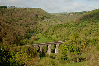
The Derwent is a river in Derbyshire, England. It is 50 miles (80 km) long and is a tributary of the River Trent, which it joins south of Derby. Throughout its course, the river mostly flows through the Peak District and its foothills.

Matlock is the county town of Derbyshire, England. It is situated in the south-eastern part of the Peak District, with the National Park directly to the west. The town is twinned with the French town of Eaubonne. The former spa resort of Matlock Bath lies immediately south of the town on the A6. The civil parish of Matlock Town had a population in the 2011 UK census of 9,543. The population of the wider Matlock urban area is approximately 20,000.

Matlock Bath is a village and civil parish in Derbyshire, England. It lies in the Peak District, south of Matlock on the main A6 road, and approximately halfway between Buxton and Derby. The population of the civil parish at the 2011 census was 753. Originally built at the head of a dead-end dirt road running along the valley of the River Derwent from Matlock, the settlement developed in the 19th century as residential and a spa town which remains a tourist destination. The steep hillside restricts development with most buildings on one side of the valley and only footbridges across the river. The road was upgraded, becoming a through-way, now designated A6, avoiding the previous coaching road approach to Matlock from Cromford over very steep hills near to the Riber plateau area.

Darley Dale, also known simply as Darley, is a town and civil parish in the Derbyshire Dales district of Derbyshire, England, with a population of around 6,000. It lies north of Matlock, on the River Derwent and the A6 road. The town forms part of the urban area of Matlock and acts as a commuter town for workers there.
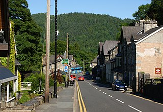
Betws-y-coed is a village and community in the Conwy valley in Conwy County Borough, Wales, located in the historic county of Caernarfonshire, right on the boundary with Denbighshire, in the Gwydir Forest. It is now a very popular visitor destination in the Snowdonia National Park.

Cromford is a village and civil parish in Derbyshire, England, in the valley of the River Derwent between Wirksworth and Matlock. It is 17 miles (27 km) north of Derby, 2 miles (3.2 km) south of Matlock and 0.5 miles (0.80 km) south of Matlock Bath. It is first mentioned in the 11th-century Domesday Book as Crumforde, a berewick of Wirksworth, and this remained the case throughout the Middle Ages. The population at the 2011 Census was 1,433. It is principally known for its historical connection with Richard Arkwright and the nearby Cromford Mill, which he built outside the village in 1771. Cromford is in the Derwent Valley Mills World Heritage Site.

Mossley Hill is a suburb of Liverpool and a Liverpool City Council ward. Located to the south of the city, it is bordered by Aigburth, Allerton, Childwall, and Wavertree. At the 2001 Census, the population was 12,650, increasing to 13,816 at the 2011 Census.

The North Wales Narrow Gauge Railways (NWNGR) was a railway company that planned to build a number of inter-connected 1 ft 11+1⁄2 in narrow-gauge railways across North Wales. The first two of these lines - jointly known as the "Moel Tryfan Undertaking" - were authorised by Act of Parliament 1872 and were built and opened in the 1870s. The original main line ran from Dinas Junction to Bryngwyn and opened in 1877. The second line was a branch from Tryfan Junction to South Snowdon, though shortly after opening, the company designated the Tryfan Junction to Bryngwyn section as the branch, and the Dinas Junction to South Snowdon section as the main line.
Abel Heywood was an English publisher, radical and mayor of Manchester.

Peak Forest is a small village and civil parish on the main road the (A623) from Chapel-en-le-Frith to Chesterfield in Derbyshire. The population of the civil parish at the 2011 census was 335.
The Manchester, Buxton, Matlock and Midland Junction Railway ran from a junction with the Midland Railway at Ambergate to Rowsley north of Matlock and thence to Buxton.
A large number of places in the U.S were named after places in England largely as a result of English settlers and explorers of the Thirteen Colonies.
Government House is the official residence of the Lieutenant Governor of the Isle of Man. It is situated on Governor's Road in Onchan, Isle of Man. Government House is also used to provide accommodation for official guests to the Isle of Man, and is used extensively for official functions, such as receptions and dinners. The property has been the official residence of the Lieutenant Governor since 1863 and has been owned by Tynwald since 1903.

Coghlan's Guides were a series of travel guide books to Europe written by Francis Coghlan in the mid-19th century.

Edward Mogg was a publisher in London in the 19th century. He issued maps and travel guides to London and other localities in England and Wales. Mogg's publications appear in works of fiction such as Robert Smith Surtees' Mr. Sponge's Sporting Tour and Shirley Brooks' The Naggletons.

Ward Lock travel guides or Red Guides (1870s–1970s) were tourist guide books to the British Isles and continental Europe published by Ward, Lock & Co. of London. The firm proclaimed them "amusing and readable" and the "cheapest and most trustworthy guides." To other readers the books were promotional and "rarely critical." Compared to similar late 19th century series such as Methuen & Co.'s Little Guides, the Ward Lock guides emphasized "travel practicalities."
Simpkin & Marshall was a British bookseller, book wholesaler and book publisher. The firm was founded in 1819 and traded until the 1940s. For many decades the firm was Britain's largest book wholesaler and a respected family-owned company, but it was acquired by the media proprietor Robert Maxwell and went bankrupt in 1954, an event which, according to Lionel Leventhal, "sounded a warning to the book trade about Captain Robert Maxwell's way of doing business".
| | This article about a travel book is a stub. You can help Wikipedia by expanding it. |