Related Research Articles

Envisat is a large Earth-observing satellite which has been inactive since 2012. It is still in orbit and considered space debris. Operated by the European Space Agency (ESA), it was the world's largest civilian Earth observation satellite.

The W. M. Keck Observatory is an astronomical observatory with two telescopes at an elevation of 4,145 meters (13,600 ft) near the summit of Mauna Kea in the U.S. state of Hawaii. Both telescopes have 10 m (33 ft) aperture primary mirrors, and, when completed in 1993 and 1996, they were the largest optical reflecting telescopes in the world. They are currently the third and fourth largest.

The Gran Telescopio Canarias is a 10.4 m (410 in) reflecting telescope located at the Roque de los Muchachos Observatory on the island of La Palma, in the Canary Islands, Spain. It is the world's largest single-aperture optical telescope.
SPOT is a commercial high-resolution optical Earth imaging satellite system operating from space. It is run by Spot Image, based in Toulouse, France. It was initiated by the CNES in the 1970s and was developed in association with the SSTC and the Swedish National Space Board (SNSB). It has been designed to improve the knowledge and management of the Earth by exploring the Earth's resources, detecting and forecasting phenomena involving climatology and oceanography, and monitoring human activities and natural phenomena. The SPOT system includes a series of satellites and ground control resources for satellite control and programming, image production, and distribution. Earlier satellites were launched using the European Space Agency's Ariane 2, 3, and 4 rockets, while SPOT 6 and SPOT 7 were launched by the Indian PSLV.

The planet Jupiter has a system of faint planetary rings. The Jovian rings were the third ring system to be discovered in the Solar System, after those of Saturn and Uranus. The main ring was discovered in 1979 by the Voyager 1 space probe and the system was more thoroughly investigated in the 1990s by the Galileo orbiter. The main ring has also been observed by the Hubble Space Telescope and from Earth for several years. Ground-based observation of the rings requires the largest available telescopes.

Satellite images are images of Earth collected by imaging satellites operated by governments and businesses around the world. Satellite imaging companies sell images by licensing them to governments and businesses such as Apple Maps and Google Maps.
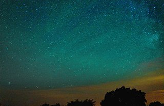
Airglow is a faint emission of light by a planetary atmosphere. In the case of Earth's atmosphere, this optical phenomenon causes the night sky never to be completely dark, even after the effects of starlight and diffused sunlight from the far side are removed. This phenomenon originates with self-illuminated gases and has no relationship with Earth's magnetism or sunspot activity.

International Ultraviolet Explorer, was the first space observatory primarily designed to take ultraviolet (UV) electromagnetic spectrum. The satellite was a collaborative project between NASA, the United Kingdom's Science and Engineering Research Council and the European Space Agency (ESA), formerly European Space Research Organisation (ESRO). The mission was first proposed in early 1964, by a group of scientists in the United Kingdom, and was launched on 26 January 1978 aboard a NASA Thor-Delta 2914 launch vehicle. The mission lifetime was initially set for 3 years, but in the end it lasted 18 years, with the satellite being shut down in 1996. The switch-off occurred for financial reasons, while the telescope was still functioning at near original efficiency.

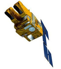
SAR-Lupe is Germany's first reconnaissance satellite system and is used for military purposes. SAR is an abbreviation for synthetic-aperture radar, and "Lupe" is German for magnifying glass. The SAR-Lupe program consists of five identical (770 kg) satellites, developed by the German aeronautics company OHB-System, which are controlled by a ground station responsible for controlling the system and analysing the retrieved data. A large data archive of images will be kept in a former Cold War bunker belonging to the Kommando Strategische Aufklärung of the Bundeswehr. The total price of the satellites was over 250 million Euro.

AstroSat is India's first dedicated multi-wavelength space telescope. It was launched on a PSLV-XL on 28 September 2015. With the success of this satellite, ISRO has proposed launching AstroSat-2 as a successor for AstroSat.

GCOM, is a JAXA project of long-term observation of Earth environmental changes. As a part of Japan's contributions to GEOSS, GCOM will be continued for 10 to 15 years with observation and utilization of global geophysical data such as precipitation, snow, water vapor, aerosol, for climate change prediction, water management, and food security. On May 18, 2012, the first satellite "GCOM-W" was launched. On December 23, 2017, the second satellite "GCOM-C1" was launched.
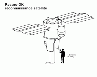
Resurs-DK No.1, also called Resurs-DK1, was a commercial Earth observation satellite capable of transmitting high-resolution imagery to the ground stations as it passed overhead. The spacecraft was operated by NTs OMZ, the Russian Research Center for Earth Operative Monitoring.

Sentinel-3 is an Earth observation heavy satellite series developed by the European Space Agency as part of the Copernicus Programme. As of 2024, it consists of 2 satellites: Sentinel-3A and Sentinel-3B. After initial commissioning, each satellite was handed over to EUMETSAT for the routine operations phase of the mission. Two recurrent satellites, Sentinel-3C and Sentinel-3D, will follow in approximately 2025 and 2028 respectively to ensure continuity of the Sentinel-3 mission.

RISAT (Radar Imaging Satellite) is a series of Indian radar imaging reconnaissance satellites built by the Indian Space Research Organization (ISRO). They provide all-weather surveillance using synthetic aperture radars (SAR).

ADEOS I was an Earth observation satellite launched by NASDA in 1996. The mission's Japanese name, Midori means "green". The mission ended in July 1997 after the satellite sustained structural damage to the solar panel. Its successor, ADEOS II, was launched in 2002. Like the first mission, it ended after less than a year, also following solar panel malfunctions.

Elektro–L is a series of meteorological satellites developed for the Russian Federal Space Agency by NPO Lavochkin. The first satellite, Elektro-L No.1, was launched on 2 January 2011. It is the first Russian weather satellite that successfully operates in geostationary orbit, and is currently the second operational Russian weather satellite. The satellites have a mass of about 1620 kg and are designed to operate for 10 years each. They are capable of producing images of the Earth's whole hemisphere in both visible and infrared frequencies, providing data for climate change and ocean monitoring in addition to their primary weather forecasting role.

GOES-16, formerly known as GOES-R before reaching geostationary orbit, is the first of the GOES-R series of Geostationary Operational Environmental Satellites (GOES) operated by NASA and the National Oceanic and Atmospheric Administration (NOAA). GOES-16 serves as the operational geostationary weather satellite in the GOES East position at 75.2°W, providing a view centered on the Americas. GOES-16 provides high spatial and temporal resolution imagery of the Earth through 16 spectral bands at visible and infrared wavelengths using its Advanced Baseline Imager (ABI). GOES-16's Geostationary Lightning Mapper (GLM) is the first operational lightning mapper flown in geostationary orbit. The spacecraft also includes four other scientific instruments for monitoring space weather and the Sun.
The Cartosat is a series of Indian optical Earth observation satellites built and operated by the Indian Space Research Organisation (ISRO). The Cartosat series is a part of the Indian Remote Sensing Program. They are used for Earth's resource management, defence services and monitoring.

The NIRSpec is one of the four scientific instruments flown on the James Webb Space Telescope (JWST). The JWST is the follow-on mission to the Hubble Space Telescope (HST) and is developed to receive more information about the origins of the universe by observing infrared light from the first stars and galaxies. In comparison to HST, its instruments will allow looking further back in time and will study the so-called Dark Ages during which the universe was opaque, about 150 to 800 million years after the Big Bang.
Satrec Initiative Co., Ltd. or SI is a South Korean satellite manufacturing company headquartered in Daejeon, South Korea The company was founded in 1999 by the engineers who developed the first Korean satellite (KITSAT-1) at KAIST SaTRec. The company designs and builds Earth observation satellites called SpaceEye-series, and it provides various space components, including high resolution electro-optical payloads and star-trackers. SI's first satellite was a Malaysian Earth observation satellite, RazakSAT launched in 2009. SI has two subsidiaries: SI Imaging Services (SIIS) is the exclusive image data provider of KOMPSAT-series, and SI Analytics (SIA) provides AI-native GEOINT solutions for satellite imagery. SI also spun-off SI Detection (SID), which provides radiation monitoring solutions.
References
- ↑ "15.4.2009: GERMANY EXPANDING OVERHEAD RECONNAISSANCE PROGRAMS AND EYE CLOSER USG PARTNERSHIP - Aftenposten". www.aftenposten.no. Archived from the original on 21 July 2012. Retrieved 6 June 2022.
- ↑ "A new German space policy?". Satelliteobservation.net. 28 December 2016.