
The Virginia Peninsula is a peninsula in southeast Virginia, USA, bounded by the York River, James River, Hampton Roads and Chesapeake Bay. It is sometimes known as the Lower Peninsula to distinguish it from two other peninsulas to the north, the Middle Peninsula and the Northern Neck.
Denbigh was a small unincorporated community in Warwick County, Virginia, USA, and was long the county seat. After a municipal consolidation in 1958, it became a neighborhood of the independent city of Newport News.
Huntington Park is a park located in Newport News, Virginia, USA. It offers a beach, two fishing piers, gardens, tennis, and museums. It is run by the Newport News Department of Parks, Recreation and Tourism.
The Denbigh Park Boat Ramp is a park located in the Denbigh area of Newport News, Virginia, USA. It is maintained by the Newport News Department of Parks, Recreation and Tourism. It is located on 13.3 acres (54,000 m2) at the southern end of Denbigh Boulevard.
Riverview Farm Park is a municipal park located in Newport News, Virginia. It is run by the Newport News Department of Parks, Recreation and Tourism.

Lee Hall is a former unincorporated town long located in the former Warwick County. Since 1958, Lee Hall has been a suburban community in the extreme western portion of the independent city of Newport News in the Commonwealth of Virginia.
Richneck Plantation was located on the Virginia Peninsula on the northern shore of the James River between Hampton Roads and Jamestown in the English colony of Virginia.
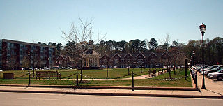
Port Warwick is a new project located in the Oyster Point area in Newport News, Virginia. It is a mixed-use new urbanism development built upon a 150-acre (0.61 km2) parcel. Port Warwick is a pedestrian-oriented community and the second-largest planned community in Newport News other than Kiln Creek. Residents can walk from home to their workplace, shops, and restaurants, or they can make a short drive of several miles to the city’s main shopping and office areas. Not far from Port Warwick is the new Oyster Point City Center, another bustling central business district in Oyster Point. It is very similar to Port Warwick, with office space and a pedestrian-friendly environment.
The Warwick River is a 14.4-mile-long (23.2 km) tidal estuary which empties into the James River a few miles from Hampton Roads at the southern end of Chesapeake Bay in southeast Virginia in the United States. Originating in York County near the northern side a few miles west of Yorktown, it flows south across the Virginia Peninsula and is almost entirely located in the independent city of Newport News.
Mulberry Island is located along the James River in the city of Newport News, Virginia, in southeastern Virginia at the confluence of the Warwick River on the Virginia Peninsula.
John B. Todd Stadium is a football stadium in Newport News, Virginia located on Warwick Boulevard between Minton and Hidenwood Drives. It is named after John B. Todd, who was a standout football player at Newport News High School and The College of William and Mary.
Hilton Elementary School is an elementary school in Newport News, Virginia. Hilton is the oldest elementary school in the city still in operation. It was completed in 1919. Hilton is a Communication Arts Magnet School.
Ferguson High School was formerly a high school in Newport News, Virginia, United States. It is named for Homer L. Ferguson, who was president of Newport News Shipbuilding from July 22, 1915 until July 31, 1946. It was operated by Newport News Public Schools. The building opened as Warwick Junior High School in 1957 and became Ferguson High School in 1961.

The Virginia War Museum is located in Huntington Park on Warwick Blvd., Newport News, Virginia. The museum contains exhibits on American military history from 1775 to the present.

Morrison was a small unincorporated community in Warwick County, Virginia. After a municipal consolidation in 1958, it became a neighborhood of the independent city of Newport News.

Skiffe's Creek is located in James City County and the independent city of Newport News in the Virginia Peninsula area of the Hampton Roads region of southeastern Virginia in the United States. It is a tributary of the James River.

The Virginia Living Museum is an open-air museum located in Newport News, Virginia that has many living exhibits of Virginia's indigenous species. The exhibits include aspects of an aquarium, science center, aviary, botanical preserve and planetarium.
Pomoco Stadium, also spelled POMOCO Stadium, is located in Newport News, Virginia, and serves as the home stadium for the Christopher Newport Captains football team since their inaugural 2001 season. Pomoco has a maximum seating capacity of 4,200, with the largest crowd ever on-hand of 6,135 occurring during the inaugural game against Salisbury University on September 1, 2001.


