Highbridge, Scotland

Last updated

The bridge as it was in 1899 High bridge, Spean Bridge.jpg
The bridge as it was in 1899

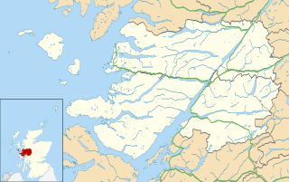
Highbridge is located on the River Spean, 2 kilometres (1.2 mi) downstream from the village of Spean Bridge in the Scottish Highlands. The village takes its name from this bridge.

Spean Bridge human settlement in the United Kingdom

Spean Bridge is a village in the parish of Kilmonivaig, in the Highland region of Scotland.

Scottish Highlands Place

The Highlands is a historic region of Scotland. Culturally, the Highlands and the Lowlands diverged from the later Middle Ages into the modern period, when Lowland Scots replaced Scottish Gaelic throughout most of the Lowlands. The term is also used for the area north and west of the Highland Boundary Fault, although the exact boundaries are not clearly defined, particularly to the east. The Great Glen divides the Grampian Mountains to the southeast from the Northwest Highlands. The Scottish Gaelic name of A' Ghàidhealtachd literally means "the place of the Gaels" and traditionally, from a Gaelic-speaking point of view, includes both the Western Isles and the Highlands.

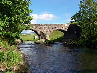
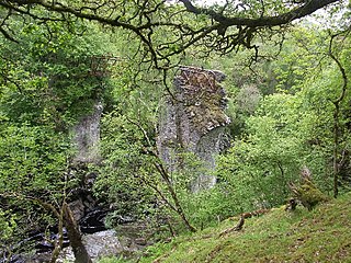
The bridge was originally built by General Wade in 1736 (at a cost of £1,087) as the crossing of the River Spean on his Inverness to Fort William military road. This bridge was superseded in 1819 by a new bridge further upstream, designed by Thomas Telford. Highbridge was last repaired in 1893, but partially collapsed in 1913, and only the piers now remain. The remains are protected as a category B listed building. [1]

River Spean

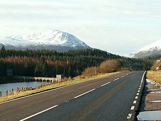
The River Spean flows from Loch Laggan in a westerly direction to join the River Lochy at Gairlochy in the Great Glen in the West Highlands of Scotland. Major tributaries of the Spean include the left-bank Abhainn Ghuilbinn and River Treig, the right-bank River Roy and the left-bank river known as The Cour. The river is accompanied by the A86 road for almost its entire length, running from (upper) Loch Laggan west to Spean Bridge. The river is spanned by a bridge carrying the A82 road near its junction with the A86 at Spean Bridge. A minor road bridges the Spean just above the falls at Inverlair. Two further road crossings exist - a private estate road across the short stretch of river between upper Loch Laggan and the Laggan reservoir and a road traversing the top of Laggan Dam. The West Highland Line crosses the river near Tulloch Station and follows its north bank before re-crossing a mile to the east of Spean Bridge. A branch of the railway formerly continued west beside the river from Spean Bridge, crossing it once again to the west of the village.

Inverness City in the Scottish Highlands, Scotland, UK

Inverness is a city in the Scottish Highlands. It is the administrative centre for The Highland Council and is regarded as the capital of the Highlands. Inverness lies near two important battle sites: the 11th-century battle of Blàr nam Fèinne against Norway which took place on the Aird and the 18th century Battle of Culloden which took place on Culloden Moor. It is the northernmost city in the United Kingdom and lies within the Great Glen at its north-eastern extremity where the River Ness enters the Moray Firth. At the latest, a settlement was established by the 6th century with the first royal charter being granted by Dabíd mac Maíl Choluim in the 12th century. The Gaelic king Mac Bethad Mac Findláich (MacBeth) whose 11th-century killing of King Duncan was immortalised in Shakespeare's largely fictionalized play Macbeth, held a castle within the city where he ruled as Mormaer of Moray and Ross.

Fort William, Highland town in the Highlands of Scotland

Fort William is a town in the Scottish Highlands, located on the eastern shore of Loch Linnhe. As of the 2011 Census, Fort William had a population of 10,459, making it the second largest settlement in the Highland council area, and the largest town - only the city of Inverness has a larger population.

The ruins of the bridge Highbridge ruins.jpg
The ruins of the bridge

It was the site of the first action of the Jacobite rising of 1745, the Highbridge Skirmish, when a small number of Keppoch MacDonalds fooled a company of troops led by Captain Scott into thinking the bridge was heavily defended. The government troops retreated and were pursued to Loch Oich, where they surrendered.

Jacobite rising of 1745 attempt by Charles Edward Stuart to regain the British throne for the exiled House of Stuart

The Jacobite rising of 1745, also known as the Forty-five Rebellion or simply the '45, was an attempt by Charles Edward Stuart to regain the British throne for his father, James Francis Edward Stuart. It took place during the War of the Austrian Succession, when the bulk of the British Army was fighting in mainland Europe, and proved to be the last in a series of revolts that began in 1689, with major outbreaks in 1708, 1715 and 1719.

Highbridge Skirmish

The Highbridge Skirmish was the first engagement of the Jacobite Rising of 1745 between British Government troops and Jacobites loyal to Prince Charles Edward Stuart. It took place at Highbridge, Lochaber, on the River Spean on 16 August 1745, and marked the commencement of hostilities between the two sides.

Clan MacDonald of Keppoch

Clan MacDonald of Keppoch, also known as Clan Ranald of Lochaber, is a Scottish clan and a branch of Clan Donald. The Clan MacDonald of Keppoch has a chief that is recognized by the Lord Lyon King of Arms and the Court of the Lord Lyon.

Related Research Articles

Lochaber ward management area of the Highland Council

Lochaber is a name applied to areas of the Scottish Highlands. Historically, it consisted of the parishes of Kilmallie and Kilmonivaig, as they were before being reduced in extent by the creation of Quoad Sacra parishes in the 19th century; this Lochaber extended from the Northern shore of Loch Leven, a district called Nether Lochaber, to beyond Spean Bridge and Roy Bridge, which area is known as Brae Lochaber or Braigh Loch Abar in Gaelic. The town of Fort William is the main urban centre and Lochaber was a distinct Province of Scotland in its own right. Lochaber is now also used to refer to a much wider area, one of the 16 ward management areas of the Highland Council of Scotland and one of eight former local government districts of the two-tier Highland region.

Highbridge, Bronx Neighborhood of the Bronx in New York City

Highbridge is a residential neighborhood geographically located in the central-west section of the Bronx, New York City. Its boundaries, starting from the north and moving clockwise are the Cross-Bronx Expressway to the north, Grand Concourse to the east, East 161st Street to the south, and the Harlem River to the west. Ogden Avenue is the primary thoroughfare through Highbridge.

Càrn Mòr Dearg mountain in the United Kingdom

Càrn Mòr Dearg is the eighth-highest mountain in Scotland. It is situated in the west of Scotland, close to the town of Fort William, in Lochaber, Highland. It lies just to the north-west of its much more famous neighbour, Ben Nevis, to which it is linked by the spectacular Càrn Mòr Dearg Arête.

A86 road road in Scotland

The A86 is a major road in Scotland. It runs from the Great Glen at Spean Bridge to Kingussie and the Cairngorms National Park via Loch Laggan. It is a primary route for its entire length.

River Forest Township, Cook County, Illinois Township in Illinois, United States

River Forest Township is one of 29 townships in Cook County, Illinois. The population was 11,172 at the 2010 census. River Forest Township is coterminous with the Village of River Forest. It is one of four coterminous townships in Cook County and one of seventeen coterminous townships statewide. Like the village, the township is bounded by Harlem Avenue, North Avenue, Madison Avenue to Lathrop Avenue, to Central Avenue and back to Harlem.

Victoria Bridge, Mar Lodge Estate bridge in United Kingdom

Victoria Bridge is the early 20th century lattice girder bridge over the River Dee at Mar Lodge on Mar Lodge Estate, Aberdeenshire, Scotland. This bridge, built in 1905 and replaced an earlier wooden bridge, built in 1848 by the Duke of Leeds during his tenancy of the estate. The archway at the south end of the bridge bears '1848 Queen Victoria 1848' on the south side and '1905 Edward VII 1905' commemorating the construction of both bridges and the reigning monarch at the time.

Stob Choire Claurigh mountain in the United Kingdom

Stob Choire Claurigh is a Scottish mountain situated 16 km (10 mi) east of Fort William in the Lochaber district of the Highland council area. It is part of one of the best ridge walks on the Scottish mainland.

Highbridge Reservoir

Highbridge Reservoir was a reservoir in the New York City water supply system, which received water from a portion of the Croton Aqueduct system. It was located on Amsterdam Avenue between 172nd Street and 174th Street, in Upper Manhattan adjacent to the High Bridge Water Tower and the High Bridge across the Harlem River Valley. The reservoir covered about 7 acres (28,000 m2), was 16 feet (4.9 m) deep, and had a total capacity of 10,794,000 US gallons (40,860,000 L).

Kilmonivaig human settlement in United Kingdom

Kilmonivaig is a small village, situated close to the southeast end of Loch Lochy in Spean Bridge, Inverness-shire, Scottish Highlands and is in the Scottish council area of Highland.

Roybridge human settlement in United Kingdom

Roybridge is a small village, that lies at the confluence of the rivers River Roy and River Spean, located 3 miles east of Spean Bridge, in Kilmonivaig Parish, Inverness-shire, Scottish Highlands and is in the Highland administrative area.

<i>Commando Memorial</i>

The Commando Memorial is a Category A listed monument in Lochaber, Scotland, dedicated to the men of the original British Commando Forces raised during World War II. Situated around a mile from Spean Bridge, it overlooks the training areas of the Commando Training Depot established in 1942 at Achnacarry Castle. Unveiled in 1952 by the Queen Mother, it is one of Scotland’s best-known monuments, both as a war memorial and as a tourist attraction offering views of Ben Nevis and Aonach Mòr.

Gattonside is a small village in the Scottish Borders. It is located 1 kilometre (0.62 mi) north of Melrose, on the north side of the River Tweed. In 1143, the lands of Gattonside were granted to the monks of Melrose Abbey by King David I. Between 1821-1824 Gattonside House became the home of Sir Adam Ferguson Deputy Keeper of the Scottish Regalia and close friend of Sir Walter Scott. More recently, Gattonside was the home of modernist architect Peter Womersley (1923–1993), whose self-designed house, The Rig (1956), is now a Category B listed building.

The Lochaber hydroelectric scheme was a hydroelectric power generation project constructed in the Lochaber area of the western Scottish Highlands after the First World War. Like its predecessor at Kinlochleven, it was intended to provide electricity for aluminium production, this time at Fort William, a little further north. It is still in operation.

Kinbuck Bridge bridge in United Kingdom

Kinbuck Bridge or Bridge of Kinbuck is a category B listed structure in the hamlet of Kinbuck in Stirling.

East Highland Way

The East Highland Way is a long distance walking route in Scotland that connects Fort William (56.8178°N 5.1109°W) with the ski and mountain resort of Aviemore (57.1899°N 3.8292°W). The route was described by the architect Kevin Langan in 2007. The name is derived from the fact that the route terminates in Aviemore at the eastern edge of Highland region. The EHW route takes in a varied and wild landscape through deep forest plantations, passing many highland lochs and negotiating unspoilt marshlands. The route also explores the ancient Caledonian forests of Inshriach. The walk is 82 miles (132 km) long.

Bridge of Cally

Bridge of Cally is a small village in Kirkmichael parish, Perth and Kinross, Scotland. It sits at the junction of three glens, Glenshee, Strathardle and Glenericht and is centred round the bridge over the River Ardle 200m before it joins the Black Water to form the River Ericht. The A93 road from Perth to Aberdeen crosses the bridge where it forms a junction with the A924 road to Kirkmichael and Pitlochry. The village is on the Cateran Trail long distance path, and is popular in winter as it is near the Glen Shee skiing area.

References

  1. Historic Environment Scotland. "BY SPEAN BRIDGE, HIGH BRIDGE OVER RIVER SPEAN  (Category B) (LB6841)" . Retrieved 22 March 2019.

Coordinates: 56°53′41″N4°57′25″W / 56.89472°N 4.95694°W / 56.89472; -4.95694

Geographic coordinate system Coordinate system

A geographic coordinate system is a coordinate system that enables every location on Earth to be specified by a set of numbers, letters or symbols. The coordinates are often chosen such that one of the numbers represents a vertical position and two or three of the numbers represent a horizontal position; alternatively, a geographic position may be expressed in a combined three-dimensional Cartesian vector. A common choice of coordinates is latitude, longitude and elevation. To specify a location on a plane requires a map projection.