Related Research Articles

The Rio Grande, known in Mexico as the Río Bravo del Norte and as the Río Bravo, is one of the principal rivers in the southwestern United States and in northern Mexico. The length of the Rio Grande is 1,896 miles (3,051 km) and originates in south-central Colorado, in the United States, and flows to the Gulf of Mexico. The Rio Grande drainage basin (watershed) has an area of 182,200 square miles (472,000 km2); however, the endorheic basins that are adjacent to and within the greater drainage basin of the Rio Grande increase the total drainage-basin area to 336,000 square miles (870,000 km2).

The Colorado River is an approximately 862-mile (1,387 km) long river in the U.S. state of Texas. It is the 18th longest river in the United States and the longest river with both its source and its mouth within Texas.

The Pecos River originates in north-central New Mexico and flows into Texas, emptying into the Rio Grande. Its headwaters are on the eastern slope of the Sangre de Cristo mountain range in Mora County north of Pecos, NM, at an elevation of over 12,000 feet (3,700 m). The river flows for 926 miles (1,490 km) before reaching the Rio Grande near Del Rio. Its drainage basin encompasses about 44,300 square miles (115,000 km2).

The Brazos River, called the Río de los Brazos de Dios by early Spanish explorers, is the 11th-longest river in the United States at 1,280 miles (2,060 km) from its headwater source at the head of Blackwater Draw, Roosevelt County, New Mexico to its mouth at the Gulf of Mexico with a 45,000-square-mile (116,000 km2) drainage basin. Being one of Texas' largest rivers, it is sometimes used to mark the boundary between East Texas and West Texas.

The Trinity River is a 710 mile long river in Texas, and is the longest river with a watershed entirely within the U.S. state of Texas. It rises in extreme northern Texas, a few miles south of the Red River. The headwaters are separated by the high bluffs on the southern side of the Red River.
The Washita River is a river in the states of Texas and Oklahoma in the United States. The river is 295 miles (475 km) long and terminates at its confluence with the Red River, which is now part of Lake Texoma on the Texas–Oklahoma border.
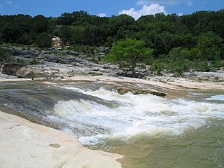
The Pedernales River is a tributary of the Colorado River, approximately 106 miles (171 km) long, in Central Texas in the United States. It drains an area of the Edwards Plateau, flowing west to east across the Texas Hill Country west of Austin. The name "Pedernales", first used in the middle 18th century, comes from a Spanish word for the flint rocks characteristic of the riverbed.

Lake Houston is a reservoir on the San Jacinto River, 15 miles (24 km) northeast of downtown Houston, Texas, United States. The reservoir is the primary municipal water supply for the city of Houston.

The Blanco River is a river in the Hill Country of Texas in the United States.

The Sulphur River is a 175-mile-long (282 km) river in northeast Texas and southwest Arkansas in the United States.

The North Fork River or the North Fork of White River is a 109-mile-long (175 km) tributary of the White River, into which it flows near Norfork, Arkansas.
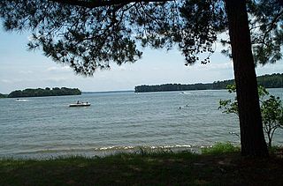
Lake Livingston is a reservoir located in the East Texas Piney Woods. Lake Livingston was built and is owned and operated by the Trinity River Authority (TRA) of Texas under contract with the City of Houston for water-supply purposes. The lake is the second-largest lake located wholly within the state of Texas. The Livingston Dam, constructed across the Trinity River about 7 miles (11 km) southwest of the city of Livingston is 2.5 miles (4 km) in length and has an average depth of 55 feet (17 m).
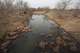
Armand Bayou is a bayou in U.S. State of Texas. It runs near Galveston Bay in Pasadena and the Clear Lake Area.
Coldwater Creek is an intermittently-flowing stream in northeastern New Mexico, and the panhandles of Oklahoma and Texas. As far back as 1907, the USGS reported that Coldwater Creek is a dry sand bed most of the year. One source says that Coldwater Creek is also known as Rabbit Ears Creek, because it rises near Rabbit Ears, a pair of mountain peaks in Union County, New Mexico. According to the United States Geological Survey (USGS), Coldwater Creek drains an area of 1,903 square miles (4,930 km2).
The Little Wichita River is a river in Texas.
Nolan River is a river in north central Texas, running through Johnson County and Hill County and is part of the Brazos River drainage basin. The Nolan's headwaters are in farm land in northwest Johnson County. The river runs generally parallel to, and about 10 miles (16 km) east of, the Brazos River. The Nolan flows in a southeasterly direction from its headwaters for about 27 miles (43 km) to its confluence with the Brazos River in the headwaters of Lake Whitney in Hill County, south of the town of Blum, Texas.
References
- "An Analysis of Texas Waterways" . Retrieved 2006-05-04.
- USGS Geographic Names Information Service
- USGS Hydrologic Unit Map - State of Texas (1974)
| | This article related to a river in Texas is a stub. You can help Wikipedia by expanding it. |