
The Platte River is a major American river, in the state of Nebraska. It is about 310 mi (500 km) long; measured to its farthest source via its tributary, the North Platte River, it flows for over 1,050 miles (1,690 km). The Platte River is a tributary of the Missouri River, which itself is a tributary of the Mississippi River which flows to the Gulf of Mexico. The Platte over most of its length is a broad, shallow, meandering stream with a sandy bottom and many islands—a braided stream.

LoDo is an unofficial neighborhood in Denver, Colorado, and is one of the oldest places of settlement in the city. It is a mixed-use historic district, known for its nightlife, and serves as an example of success in urban reinvestment and revitalization. The current population is approximately 21,145.

Confluence Park is an urban park encompassing the confluence of Cherry Creek and the South Platte River in Denver's Lower Downtown (LoDo), a bustling district of 19th-century brick warehouses and storefronts that has been redeveloped since the late 1980s.
The list of neighborhoods of Kansas City, Missouri has nearly 240 neighborhoods. The list includes only Kansas City, Missouri and not the entire Kansas City metropolitan area, such as Kansas City, Kansas.
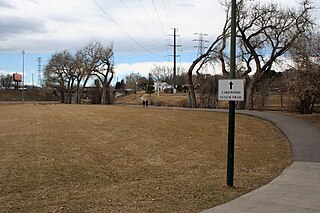
Lakewood Gulch drains a section of Lakewood and west Denver, Colorado into the South Platte River. It is the historic location of the old Interurban Shortline Railway and, in 2008, is a greenbelt that includes Rude Park, Sanchez Park and Lakewood Gulch Park. The gulch passes through Lakewood from west to east before entering the Denver neighborhoods of Sun Valley and Villa Park. It contains a part of the route of the (current) heritage streetcar Platte Valley Trolley and the Denver sections of the creek have an adjacent bike path. According to the Jefferson County Colorado Place Names Directory, "Lakewood Gulch originates on the north east foot of Green Mountain in Lakewood, flows east through Sixth Avenue West Park and Red Rocks Community College and continues east through Lakewood into Denver, where it joins the South Platte River southwest of the intersection of I-25 and Colfax Avenue."

Jefferson Park is a neighborhood and public park that overlooks Downtown Denver, Colorado from its perch across Interstate 25 (I-25). It is located in the area that is called North Denver. Views east from Jefferson Park take in Elitch Gardens Theme Park, The Children's Museum, Denver's Downtown Aquarium, Pepsi Center, the REI flagship store and other attractions in Downtown's Central Platte Valley. Downtown Denver and the Central Platte Valley are quickly accessed from Jefferson Park, using the 23rd Avenue overpass on I-25 and Water Street. In addition, the Light Rail C-Line is located by Empower Field at Mile High in the southern part of the neighborhood.

Highland is a distinct city-center neighborhood in Denver, Colorado, United States, bounded by West 38th Avenue to the north, a Union Pacific Railroad line on the east, the South Platte River to the southeast, Speer Boulevard on the south, and Federal Boulevard on the west. The Highlands is sometimes used to refer to two separate city-center neighborhoods in Denver; Highland and West Highland, although the two neighborhoods are distinct. Highland and West Highland are both in the area that is referred to as the Northside. Highland is located immediately northwest of downtown. Note that the Highland neighborhood association has a slightly different definition with the easternmost boundary stopping at I-25. And the West Highland neighborhood to the immediate west of Highland, with the borders of 38th and 29th Avenues on the north and south and Federal and Sheridan Boulevards on the east and west. To distinguish between its immediately adjacent neighbor, West Highland, Highland is sometimes referred to as East Highland, Lower Highland or LoHi. The two together are casually called "the Highlands," a term which often falsely encompasses other Northwest Denver neighborhoods such as Jefferson Park, Sunnyside and Berkeley. Realtors have particularly pushed the inclusion of the recently gentrified Berkeley, located directly north of West Highland, as part of the Highlands, sometimes going so far as to refer to Berkeley and parts of Sunnyside as the "Upper Highlands". To add further confusion, within the Highlands neighborhoods there are several historic designations of various degrees, including Potter Highlands, Scottish Highlands and Highlands Park.

There are more than 300 properties and districts listed on the National Register of Historic Places in the City and County of Denver, the capital of the U.S. State of Colorado.
This National Park Service list is complete through NPS recent listings posted January 17, 2025.
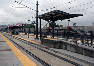
Ball Arena–Elitch Gardens is an at-grade light rail station on the E Line and W Line of the RTD Rail system. It is located near the intersection of 9th Street and Chopper Circle in Denver, Colorado, near Ball Arena and Elitch Gardens Theme Park, after which the station is named.

Sun Valley is a neighborhood in central Denver, Colorado, bordered by I-25 on the east, Federal Blvd. on the west, 6th Avenue on the south and 20th Ave. on the north. It is located in the area known as West Denver.

The Denver Millennium Bridge is the world's first cable-stayed bridge using post-tensioned structural construction. Located near LoDo, in Riverfront Park, it connects the 16th Street Mall with the Commons Park in the Central Platte Valley District of the Union Station neighborhood. The bridge is one of three pedestrian bridges between Downtown Denver and the Highland neighborhood.

The 19th Street Bridge is a two-span through Pratt truss road bridge in Denver, Colorado, over the South Platte River, now used for pedestrians. It was built in 1888 to replace a wooden structure and carried automobile traffic until 1986. The bridge is listed on the National Register of Historic Places.

South Platte River Bridges were a pair of historic arch bridges that carried Denver's Valley Highway, since designated Interstate 25, over the South Platte River. Between May 2011 and August 2013, these bridges were replaced due to deterioration of the structures.

The Platte River Bridge is the second of three pedestrian bridges to connect Downtown Denver with the Highland neighborhood.

Union Station is a downtown neighborhood of Denver, Colorado. In 2020, the population of the neighborhood was roughly 5,878.

The Overland Trail was a stagecoach and wagon trail in the American West during the 19th century. While portions of the route had been used by explorers and trappers since the 1820s, the Overland Trail was most heavily used in the 1860s as a route alternative to the Oregon, California, and Mormon trails through central Wyoming. The Overland Trail was famously used by the Overland Stage Company owned by Ben Holladay to run mail and passengers to Salt Lake City, Utah, via stagecoaches in the early 1860s. Starting from Atchison, Kansas, the trail descended into Colorado before looping back up to southern Wyoming and rejoining the Oregon Trail at Fort Bridger. The stage line operated until 1869 when the completion of the First transcontinental railroad eliminated the need for mail service via stagecoach.

Guillermo "Bill" Vidal is a Cuban American author and career civil servant who served as the 44th mayor of Denver, Colorado.

Union Station North, formerly known as Prospect, is a neighborhood within the city limits of Denver, Colorado. Previously dominated by industrial buildings, waste, railroad tracks and considered an area of the city to be avoided, today it has been rehabilitated into multi-story residential buildings, restaurants, amenities, easy access to downtown Denver, and is a short walk to the South Platte River Trail, which runs along its northern boundary.
