The Delaware River is a major river in the Mid-Atlantic region of the United States and is the longest free-flowing (undammed) river in the Eastern United States. From the meeting of its branches in Hancock, New York, the river flows for 282 miles (454 km) along the borders of New York, Pennsylvania, New Jersey, and Delaware, before emptying into Delaware Bay.

The East Coast of the United States, also known as the Eastern Seaboard, the Atlantic Coast, and the Atlantic Seaboard, is the region encompassing the coastline where the Eastern United States meets the Atlantic Ocean. The Thirteen Colonies, which formed the United States in 1776 were located on this coast, and it has played an important role in the development of the United States.

Sussex County is the northernmost county in the U.S. state of New Jersey. Its county seat is Newton. It is part of the New York metropolitan area and is part of New Jersey's Skylands Region. As of the 2020 census, the county was the state's 17th-most-populous county, with a population of 144,221, a decrease of 5,044 (−3.4%) from the 2010 census count of 149,265, which in turn reflected an increase of 5,099 (+3.5%) over the 144,166 persons at the 2000 census. Based on 2020 census data, Vernon Township was the county's largest in both population and area, with a population of 22,358 and covering an area of 70.59 square miles (182.8 km2). The county is part of the North Jersey region of the state.

The Mid-Atlantic is a region of the United States located in the overlap between the Northeastern and Southeastern states of the United States. Its exact definition differs upon source, but the region typically includes New Jersey, Maryland, Virginia, Delaware, West Virginia, District of Columbia, and Pennsylvania. Some sources include New York, while others exclude Pennsylvania. However, according the U.S. Bureau of Labor Statistics (BLS), the states listed above are commonly accepted as the Mid-Atlantic region. The region has its origin in the Middle Colonies of the 18th century when its states were among the Thirteen Colonies of pre-revolutionary British America. As of the 2020 census, the region had a population of 60,783,913, representing slightly over 18% of the nation's population.

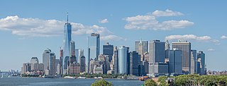
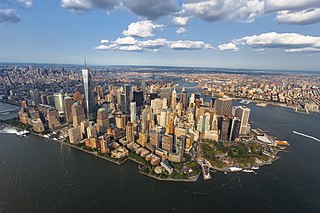
The New York metropolitan area, broadly referred to as the Tri-State area and often also called Greater New York, is the largest metropolitan area in the world by urban landmass, encompassing 4,669.0 sq mi (12,093 km2). The New York metropolitan area is one of the most populous metropolitan areas in the world, the largest metropolitan area in the U.S., and the only U.S. metropolitan area home to more than 20 million residents as of the 2020 United States census.

The Northeastern United States is one of the four census regions defined by the United States Census Bureau. Located on the Atlantic coast of North America, the region borders Canada to its north, the Southern United States to its south, the Midwestern United States to its west, and the Atlantic Ocean to its east.
In the United States, an interstate compact is a pact or agreement between two or more states, or between states and any foreign sub-national government.

The Eastern United States, often abbreviated as simply the East, is a macroregion of the United States located to the east of the Mississippi River. It includes 17–26 states and Washington, D.C., the national capital.

A borough in some U.S. states is a unit of local government or other administrative division below the level of the state. The term is currently used in six states:

New Jersey is a state within the United States of America that lies on the north eastern edge of the North American continent. It shares a land border with the state of New York along the north, ratified by both states after the New York – New Jersey Line War, which is its only straight line border.

The Regional Plan Association is an independent, not-for-profit regional planning organization, founded in 1922, that focuses on recommendations to improve the quality of life and economic competitiveness of a 31-county New York–New Jersey–Connecticut region in the New York metropolitan area. Headquartered in New York City, it has offices in Princeton, New Jersey, and Stamford, Connecticut.

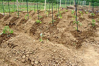
Benjamin Rush State Park is a 275-acre (111 ha) Pennsylvania state park in Philadelphia, Philadelphia County, Pennsylvania, in the United States. The park is undeveloped and is the site of community gardens, believed to be one of the largest in the world. The park is home to the Northeast Radio Controlled Airplane Club. Benjamin Rush State Park is in Northeast Philadelphia at the intersection of Southampton Road and Roosevelt Boulevard. The northern boundary of the park is formed by Poquessing Creek. There are several acres of woodlands along the creek bank. A proposal map show plans to connect the park with Fairmount Park. Other proposed improvements included hiking trails, parking facilities, and a reforestation project. The community gardens and airfield for the radio-controlled aircraft would remain.

The Northeast megalopolis, also known as the Northeast Corridor, Acela Corridor, Boston–Washington corridor, BosWash, or BosNYWash, is the most populous megalopolis exclusively within the United States, with slightly over 50 million residents as of 2022. It is the world's largest megalopolis by economic output.
The Farmington Valley is located along the western boundary of Hartford County in Connecticut, bordering Litchfield County immediately to the west. It is defined by the Farmington River, which runs through it. Physiographically, the valley is lowlands and floodplain flanked by the Litchfield Hills on the west and Talcott Mountain on the east.

New England is a region comprising six states in the Northeastern United States: Connecticut, Maine, Massachusetts, New Hampshire, Rhode Island, and Vermont. It is bordered by the state of New York to the west and by the Canadian provinces of New Brunswick to the northeast and Quebec to the north. The Gulf of Maine and Atlantic Ocean are to the east and southeast, and Long Island Sound is to the southwest. Boston is New England's largest city and the capital of Massachusetts. Greater Boston is the largest metropolitan area, with nearly a third of New England's population; this area includes Worcester, Massachusetts, the second-largest city in New England; Manchester, New Hampshire, the largest city in New Hampshire; and Providence, Rhode Island, the capital of and largest city in Rhode Island.

In the United States, the forest cover by state and territory is estimated from tree-attributes using the basic statistics reported by the Forest Inventory and Analysis (FIA) program of the Forest Service. Tree volumes and weights are not directly measured in the field, but computed from other variables that can be measured.

The Ramapo Fault zone is a system of faults between the northern Appalachian Mountains and Piedmont areas to the east. Spanning more than 185 miles (298 km) in New York, New Jersey, and Pennsylvania, it is perhaps the best known fault zone in the Mid-Atlantic region, and some small earthquakes have been known to occur in its vicinity. Recently, public knowledge about the fault has increased, especially after the 1970s, when the fault's proximity to the Indian Point nuclear plant in New York was noted.
Pyrgus centaureae wyandot, the Appalachian grizzled skipper, is a small, brown, gray and white butterfly known to inhabit parts of the Appalachian highlands and Northern Michigan. It can be identified by its characteristic checkered wing pattern formed by the scales on the fore- and hindwings. The butterflies are known to prefer sites with minimal vegetation, such as open areas in hardwood forests, as well as sites of recent disturbance. The skipper's main larval food plants include Canada cinquefoil and wild strawberry depending on the specific population's range. The butterfly is listed as a federal species of concern and holds a state endangered title in Ohio and New Jersey.

The New York – New Jersey Highlands is a geological formation composed primarily of Precambrian igneous and metamorphic rock running from the Delaware River near Musconetcong Mountain, northeast through the Skylands Region of New Jersey along the Bearfort Ridge and the Ramapo Mountains, Sterling Forest, Harriman and Bear Mountain State Parks in New York, to the Hudson River at Storm King Mountain. The northern region is also known as the Hudson Highlands and the southern as the New Jersey Highlands. A broader definition would extend the region west to Reading, Pennsylvania, and east to the Housatonic River in Connecticut, encompassing the Reading Prong. The highlands are a subrange of the Appalachian Mountains.


