 | |
|---|---|
| ٦ طريق رقم | |
| Location | |
| Country | Iraq |
| Highway system | |
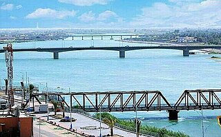
Highway 6 is an Iraqi highway which extends from Baghdad to Basrah. It passes through Al Kut and Al Amarah. [1]
| | |
|---|---|
| ٦ طريق رقم | |
| Location | |
| Country | Iraq |
| Highway system | |
Highway 6 is an Iraqi highway which extends from Baghdad to Basrah. It passes through Al Kut and Al Amarah. [1]

Transport in Syria is possible by rail, road, air or rivers, both public and private. Syria is an Asian country with a well-developed rail network (2,052 km) and a highway system (782 km). Main international airport is the Damascus International Airport in the capital, Damascus.
Fallujah is a city in Al Anbar Governorate, Iraq. Situated on the Euphrates River, it is located roughly 69 kilometres (43 mi) to the west of the capital city of Baghdad.

The Battle of Ramadi was fought in the spring of 2004, during the same time as the First Battle of Fallujah, for control of the capital of the Al Anbar Governorate in western Iraq. A coalition military force consisting of the 2nd Battalion, 4th Marines were stationed to defend the city from an insurgent assault.
Al-Shatrah is a town in southern Iraq, located northeast of Nasiriyah. It is the administrative capital of the al-Shatrah District, a part of the Dhi Qar Governorate. Al-Shatrah is situated along the Gharraf Canal at the intersection with Highway 7. It lies 22.35 km west of the ancient city of Lagash. In 2009, it had a population estimated 254,000.
Operation Dawn-1 was an Iranian offensive in the Iran–Iraq War. On April 10, 1983, Iran struck Ayn Al-Qaws with the immediate objective of Al-Fakkah Field to capture the Baghdad-Basra Highway. The operation was fought mostly by Pasdaran forces and was one of the three costly human wave offensives of 1983, the Iranians failed to defeat the Iraqis.
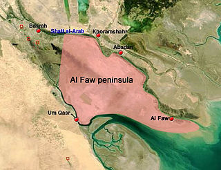
The Battle of Al Faw was one of the first battles of the Iraq War; it took place March 20-24, 2003.

Al-Saydiya is a neighborhood in the Al Rashid district of southwestern Baghdad, Iraq. Baiyaa is to the north and Dora to the east.

Arar is the capital of Northern Borders Province in Saudi Arabia. It has a population of 202,719.
Highway 1 is an Iraqi highway which extends from Baghdad to Qamishli in Syria. It connects Baghdad directly to Anbar’s provincial capital of Ramadi and passes through Baqubah, Taji, Samarra, Tikrit and Mosul.
Highway 2 is an Iraqi highway which extends from Baghdad to Silopi in Turkey. It passes through Baqubah, Al Khalis, Kirkuk, Erbil, Mosul, Dohuk and Zakhu.
Highway 8 is an Iraqi highway which extends from Baghdad, through Al Hillah, Al-Qādisiyyah, As Samawah, Nasiriyah, Basrah, to the Kuwait frontier.
Highway 9 is an Iraqi highway which extends from Karbala, through Al Najaf, to Al-Qādisiyyah. The highway saw military action during the U.S. Invasion of Iraq.
Highway 11 is an Iraqi highway which extends from Baghdad to Syria. It passes through Al Fallujah, Al Ramadi, Al Habbaniyah and Ar Rutbah.
Highway 12 is an Iraqi highway which extends from Al Ramadi, through Hīt, Haditha, Al-Karābilah, to the Syria frontier.

Al Jahra is a city and area located 32 kilometres (20 mi) west of the centre of Kuwait City in Kuwait. Al Jahra is the capital of the Al Jahra Governorate of Kuwait as well as the surrounding Al Jahra District which is agriculturally based. Encyclopædia Britannica recorded the population in 1980 as 67,311. Historically, Jahra was a predominantly agricultural area. There are currently various farms in Jahra.
The Battle of Dasman Palace, also called the Battle of Dasman, took place between the Kuwaiti and Iraqi forces during the Iraqi invasion of Kuwait on 2 August 1990.
Al-Mada'in District is a district of the Baghdad Governorate, Iraq. It includes the city of Salman Pak, which incorporates the ancient ruins of Al-Mada'in, and the oldest freestanding mud brick arch in the world. Other metropolitan areas include Jisr Dyala, an urban district that borders the Baghdad city district of (???), the northern village of Nahrawahn with its major brickworks, and the central village of Wahedah that sits astride the Basrah Highway into Wasit Province.
Freeway 1 is the first and longest freeway in Iraq. It is 1,200 kilometres (750 mi) long. It extends from Umm Qasr Port in Basra to Ar Rutba in Anbar, where it spreads into a new freeway with same number towards Syria and Jordan.

Operation al-Shabah was launched in May 2013 by the Iraqi Army, with the stated aim of severing contact between the Islamic State of Iraq and the Levant and the al-Nusra Front in Syria by clearing militants from the border area with Syria and Jordan.
| Freeways | ||
|---|---|---|
| Roads and Highways | ||
| | This Iraq geographical location article is a stub. You can help Wikipedia by expanding it. |
| | This article related to a road in Asia is a stub. You can help Wikipedia by expanding it. |
| | This article about transport in Iraq is a stub. You can help Wikipedia by expanding it. |