
The Ohio River is a 981-mile (1,579 km) long river in the midwestern United States that flows southwesterly from western Pennsylvania south of Lake Erie to its mouth on the Mississippi River at the southern tip of Illinois. It is the second largest river by discharge volume in the United States and the largest tributary by volume of the north-south flowing Mississippi River that divides the eastern from western United States. The river flows through or along the border of six states, and its drainage basin includes parts of 15 states. Through its largest tributary, the Tennessee River, the basin includes several states of the southeastern U.S. It is the source of drinking water for three million people.

The Allegheny River is a 325-mile (523 km) long headwater stream of the Ohio River in western Pennsylvania and New York, United States. The Allegheny River runs from its headwaters just below the middle of Pennsylvania's northern border northwesterly into New York then in a zigzag southwesterly across the border and through Western Pennsylvania to join the Monongahela River at the Forks of the Ohio on the "Point" of Point State Park in Downtown Pittsburgh, Pennsylvania. The Allegheny River is, by volume, the main headstream of both the Ohio and Mississippi Rivers. Historically, the Allegheny was considered to be the upper Ohio River by both Native Americans and European settlers.

Greensboro is a borough in Greene County, Pennsylvania, United States. The population was 260 at the 2010 census, down from 295 at the 2000 census.

Rivesville is a town and former coal town in Marion County, West Virginia, United States. The population was 934 at the 2010 census.

The Youghiogheny River, or the Yough for short, is a 134-mile-long (216 km) tributary of the Monongahela River in the U.S. states of West Virginia, Maryland, and Pennsylvania. It drains an area on the west side of the Allegheny Mountains northward into Pennsylvania, providing a small watershed in extreme western Maryland into the tributaries of the Mississippi River. Youghiogheny is a Lenape word meaning "a stream flowing in a contrary direction".

The Cheat River is a 78.3-mile-long (126.0 km) tributary of the Monongahela River in eastern West Virginia and southwestern Pennsylvania in the United States. Via the Ohio River, the Cheat and Monongahela are part of the Mississippi River watershed. Owing to the ruggedness of the surrounding Allegheny Mountains, the Cheat remains largely remote with few settlements or developments along its banks. Its headwaters are in the Cheat-Potomac Ranger District of the Monongahela National Forest.
Transportation in West Virginia includes the following.

Allegheny Islands State Park is a 43-acre (17 ha) Pennsylvania state park in Harmar Township, Allegheny County, Pennsylvania in the United States. The undeveloped park is composed of three alluvial islands located in the middle of the Allegheny River northeast of Pittsburgh. The islands are just north of the boroughs of Oakmont and Plum, and southwest of Cheswick. Bridges for the Pennsylvania Turnpike and the Bessemer and Lake Erie Railroad Branch of the Canadian National Railway cross the Allegheny River at the middle island.

Turtle Creek is a 21.1-mile-long (34.0 km) tributary of the Monongahela River in Allegheny and Westmoreland counties in the U.S. state of Pennsylvania. At its juncture with the Monongahela is Braddock, Pennsylvania, where the Battle of the Monongahela was fought in 1755. In the mid-19th century, the Pennsylvania Railroad laid tracks along the stream as part of its Main Line from Philadelphia to Pittsburgh.
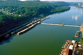
Point Marion Lock and Dam, previously known as Lock and Dam Number 8, is one of nine navigational structures on the Monongahela River between Pittsburgh, Pennsylvania and Fairmont, West Virginia. Maintained and built by the U.S. Army Corps of Engineers, the gated dam forms an upstream pool that is 11.2 miles (18.0 km) long, stretching to the base of the Morgantown Lock and Dam. It is located at river mile 90.5.

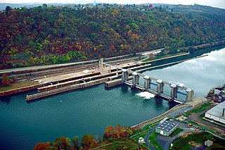
Maxwell Lock and Dam is a navigational lock and gated dam on the Monongahela River between Centerville in Washington County, and Luzerne Township in Fayette County in Pennsylvania. It is part of a series of dams that canalizes the Monongahela to a depth of at least 9 feet (2.7 m) for its entire length from Fairmont, West Virginia to Pittsburgh, Pennsylvania. It is maintained by the U.S. Army Corps of Engineers, Pittsburgh District.

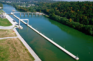
Grays Landing Lock and Dam, previously known as Lock and Dam Number 7, is one of nine navigational structures on the Monongahela River between Pittsburgh, Pennsylvania and Fairmont, West Virginia. Maintained and built by the U.S. Army Corps of Engineers, the gated dam forms an upstream pool that is 11.2 miles (18.0 km) long, stretching to the base of the Point Marion Lock and Dam. It is located at river mile 82.
Braddock Locks & Dam is one of nine navigational structures on the Monongahela River between Pittsburgh, Pennsylvania and Fairmont, West Virginia. Built and maintained by the U.S. Army Corps of Engineers, the gated dam and the lock form an upstream pool that is for 12.6 miles (20.3 km), stretching to Elizabeth, Pennsylvania.
Elizabeth Locks & Dam is one of nine navigational structures on the Monongahela River between Pittsburgh, Pennsylvania and Fairmont, West Virginia. Maintained and built by the U.S. Army Corps of Engineers, the gated dam forms an upstream pool that extends for 23.8 miles, stretching to Charleroi, Pennsylvania.
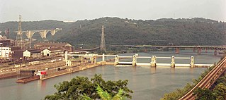
Charleroi Locks & Dam, officially known as Locks & Dam 4 by the US Army Corps of Engineers, is one of nine navigational structures on the Monongahela River between Pittsburgh, Pennsylvania and Fairmont, West Virginia. Maintained and built by the U.S. Army Corps of Engineers, the gated dam forms an upstream pool that is for 19.7 miles to the Maxwell Lock & Dam.
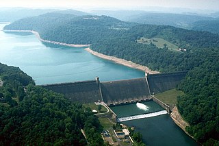
Tygart Dam — also known as Tygart River Dam — is a federally built and operated dam in Taylor County, West Virginia, United States. The dam regulates the waters of the Tygart Valley River. Its storage reservoir is known as Tygart Lake. Most of the lakeshore is occupied by Tygart Lake State Park and Pleasant Creek Wildlife Management Area. The structure was listed on the National Register of Historic Places in 1995.


