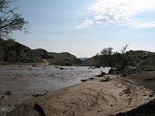
The Kuiseb River is an ephemeral river in western-central Namibia. Its source is in the Khomas Highland west of Windhoek. From there it flows westwards through the Namib-Naukluft National Park and the Namib desert to Walvis Bay. Several settlements of the Topnaar people are on the banks of the lower Kuiseb, for instance Homeb, Sandfontein, Rooibank, and Utuseb. Inflows of the Kuiseb are Gomab, Ojab, Chausib, Gaub, Koam, Nausgomab and Goagos.

The Skeleton Coast is the northern part of the Atlantic coast of Namibia. Immediately south of Angola, it stretches from the Kunene River to the Swakop River, although the name is sometimes used to describe the entire Namib Desert coast. The indigenous San people, of the Namibian interior called the region "The Land God Made in Anger", while Portuguese sailors once referred to it as "The Gates of Hell".

The Ugab River is an ephemeral river in north-western Namibia. Its lower section forms the border between Kunene Region and Erongo Region but its catchment area extends well into the Otjozondjupa Region. Ugab's source is near Otavi. From there the riverbed leads westwards past the Paresis Mountains and the Fransfontein Mountains into the Skeleton Coast and the Atlantic Ocean. Inflows of the Ugab are Erundu, Ozongombo, Okomize and Uis.

Ontario Lacus is a lake composed of methane, ethane and propane near the south pole of Saturn's moon Titan. Its character as a hydrocarbon lake was confirmed by observations from the Cassini spacecraft, published in the 31 July 2008 edition of Nature. Ontario Lacus has a surface area of about 15,000 square kilometers (5,800 sq mi), about 20% smaller than its terrestrial namesake, Lake Ontario in North America. In April 2012, it was announced that it may be more like a mudflat or salt pan.

Omuramba is the term for ancient river-beds found in the Kalahari Desert of Africa, notably in the North Eastern part of Namibia and North Western part of Botswana. The word is taken from the Herero language. An omuramba provides occasional standing pools of water and more fertility than in the surrounding sand plains. Some specific omiramba are named: Eiseb, Rietfontein, Epukiro, Omatako. They mostly start in the central parts of Namibia and run into the central parts of Botswana.

Outjo is a town of 15,000 inhabitants in the Kunene Region of Namibia. It is the district capital of Outjo Constituency. It is best known as the main gateway to Etosha National Park.

Uis is a settlement located in the Erongo Region, Namibia. It belongs to the Dâures electoral constituency. Located in the former Damaraland, it is known for the local mineral wealth. The settlement was established in 1958 as workers' settlement to exploit local tin deposits. It has approximately 3,600 inhabitants and, before being downgraded from "village" to "settlement" in 2010, owned 10 square kilometres (3.9 sq mi) of land.

The Swakop River is a major river in western central Namibia. Its source is in the Khomas Highland. From there it flows westwards through the town of Okahandja, the historic mission station at Gross Barmen, and the settlement of Otjimbingwe. It then crosses the Namib desert and reaches the Atlantic Ocean at Swakopmund. The Swakop is an ephemeral river; its run-off is roughly 40 million cubic metres per annum.

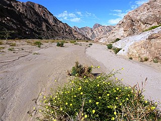
The Tsauchab is an ephemeral river in the Hardap Region of central Namibia. Its source is in the southern Naukluft Mountains, from where it flows westwards through the Namib-Naukluft National Park into Sossusvlei, an endorheic basin. The lower river has in the past had a slightly different courses and also formed two other basins, the Deadvlei and the Hiddenvlei.

The Fortescue River is an ephemeral river in the Pilbara region of Western Australia. It is the third longest river in the state.
The river Khan is an ephemeral river crossing the Erongo region of central Namibia. It is the main tributary of the Swakop River and only occasionally carries surface water during the rainy season from November to February/March. Khan's catchment area including its tributaries Slang and Etiro stretches over 8,400 square kilometres (3,200 sq mi).

The Omaruru River is a major river crossing the Erongo Region of western central Namibia from East to West. It originates in the Etjo Mountains, crosses the town of Omaruru and the village of Okombahe, and reaches the sea a few kilometers north of Henties Bay. Inflows of the Omaruru are Otjimakuru, Goab, Spitzkop, Leeu and Okandjou.
The Uniab River is an ephemeral river on Namibia's Skeleton Coast, located between Torra Bay and Terrace Bay. Its origin is in the Grootberg Mountains near Palmwag. Inflows of the Uniab are Kaikams, Kawakab, Aub, Urenindes and Obob. The river once created a large river delta with five main watercourses. Today it continues to flow only in one of the watercourses, but subterranean water surfaces as springs in the other channels. Uniab's catchment area is estimated to be between 3961 and 4,500 km2 (1,700 sq mi).

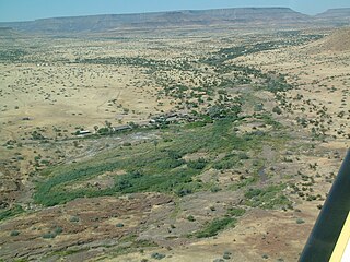
The Hoanib is one of the 12 ephemeral seasonal rivers in the west of Namibia, where it used to be the border between northern Damaraland and Kaokoland. Its length is 27 kilometres (17 mi). With the low population density in the area, the oasis character of the river valley and the relatively high wildlife population of the Hoanib, like in the case of the Hoarusib, its valley is one of the last true wilderness areas in Namibia. One of the last settlements of desert elephants, it is characterised by strong wind and water eroded, weathered stone deposits. Inflows of Hoanib are Aap River, Otjitaimo River, Ombonde, Ganamub, Mudorib and Tsuxub.

Desert elephants or desert-adapted elephants are not a distinct species of elephant but are African bush elephants that have made their homes in the Namib and Sahara deserts in Africa. Previously they were classified as a subspecies of the African bush elephant, but this is no longer the case. Desert-dwelling elephants were once more widespread in Africa than they are at present; they are currently found only in Namibia and Mali. They tend to migrate from one waterhole to another following traditional routes which depend on the seasonal availability of food and water. They face being threatened by poaching and from changes in land use by humans.
The river Khumib is an ephemeral river crossing the Kunene Region of north-western Namibia. It occasionally carries surface water during the rainy seasons in November and February/March. Its catchment area is estimated between 2200 and 2,300 square kilometres (890 sq mi).

The Koigab River is an ephemeral river on Namibia's Skeleton Coast. Its source is in the Grootberg Mountains near Bergsig, where its two inflows, the Gui-Tsawisib and the Springbok are located. Koigab's catchment area is estimated to be between 2320 and 2,400 km2 (930 sq mi).
The Huab River is an ephemeral river in the Kunene Region of north-western Namibia. Its source is southeast of Kamanjab, from where it flows westwards through Mopane savanna until it reaches the Skeleton Coast and the Atlantic Ocean. Inflows of the Huab are Klein-Omaruru, Sout, Aba-Huab, Ongwati and Klip. Huab's catchment area is estimated to be between 14,800 and 16,465 km2 (6,357 sq mi), and includes the town of Khorixas as well as the settlements Kamanjab, Fransfontein, and Anker. The Twyfelfontein World Heritage Site is located on the banks of the Aba Huab.

The Tsondab River is an ephemeral river in the Hardap Region of central Namibia. Its source is in the Remhoogte Mountains. From there it flows westwards through the Namib-Naukluft National Park before evaporating at Tsondabvlei. Inflows of the Tsondab are Diep, Noab and Koireb. Tsondab's catchment area is 3,500 km2 (1,400 sq mi).
