The East Riding of Yorkshire, often abbreviated to the East Riding or East Yorkshire, is a ceremonial county in the Yorkshire and the Humber region of England. It borders North Yorkshire to the north and west, South Yorkshire to the south-west, and Lincolnshire to the south across the Humber Estuary. The city of Kingston upon Hull is the largest settlement.
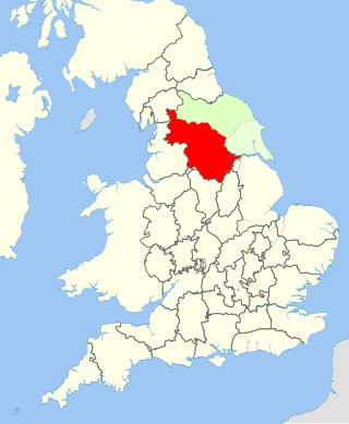
The West Riding of Yorkshire was one of three historic subdivisions of Yorkshire, England. From 1889 to 1974 the riding was an administrative county named County of York, West Riding. The lieutenancy at that time included the city of York and as such was named "West Riding of the County of York and the County of the City of York". The riding ceased to be used for administrative purposes in 1974, when England's local government was reformed.

The North Riding of Yorkshire was a subdivision of Yorkshire, England, alongside York, the East Riding and West Riding. The riding's highest point was at Mickle Fell at 2,585 ft (788 m).

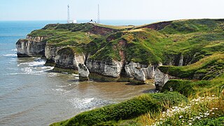
Bridlington is a seaside town and civil parish in the East Riding of Yorkshire, England. It is on the Holderness part of the Yorkshire Coast by the North Sea. The town is about 28 miles (45 km) north of Hull and 34 miles (55 km) east of York. The stream called Gypsey Race flows through the town and enters the North Sea at the harbour.
Darton is a large village in the Metropolitan Borough of Barnsley, on the border with West Yorkshire, England. At the time of the 2001 UK census, it had a population of 14,927, increasing to 21,345 for both Darton Wards at the 2011 Census.

Staincross is a village in South Yorkshire, England, on the border with West Yorkshire. Historically part of the West Riding of Yorkshire, it formed part of the defunct Barnsley West and Penistone borough constituency, following the Boundary Commission for England's report on South Yorkshire's Parliamentary constituencies in 2004 and the subsequent inquiry in 2005, it is now part of the Barnsley Central borough constituency. The population now falls within the Darton East ward of the Metropolitan Borough of Barnsley. The village also gave its name to the Staincross wapentake in the West Riding of Yorkshire. It is situated about 3 miles (4.8 km) from Barnsley, and 8 miles (13 km) from Wakefield.

The Tees Valley is a combined authority area in Northern England, around the lower River Tees. The area is not a geographical valley; the local term for the valley is Teesdale. The combined authority covers five council areas: Darlington, Hartlepool, Middlesbrough, Redcar and Cleveland and Stockton-on-Tees.
Beverley and Holderness is a county constituency in the East Riding of Yorkshire for the House of Commons of the Parliament of the United Kingdom. It elects one Member of Parliament (MP) at least once every five years by the first-past-the-post electoral system. The constituency has been represented by Graham Stuart of the Conservative Party since the 2005 general election.
The Ainsty or the Ainsty of York was a historic district of Yorkshire, England, west of the city of York. Originally a wapentake or subdivision of the West Riding of Yorkshire it later had a unique status as a rural area controlled by the corporation of the city.

Norton-on-Derwent, commonly referred to as simply Norton, is a town and civil parish in North Yorkshire, England. Norton borders the market town of Malton, and is separated from it by the River Derwent. The 2001 Census gave the population of the parish as 6,943, increasing at the 2011 Census to 7,387.

Brandesburton is a village and civil parish in the East Riding of Yorkshire, England. It is situated approximately 7 miles (11 km) west of Hornsea and 9 miles (14 km) north-east of the market town of Beverley.
Buckrose was a county constituency of the House of Commons of the Parliament of the United Kingdom, comprising the northern part of the East Riding of Yorkshire, represented by one Member of Parliament, and was created for the 1885 general election.
Northern West Riding of Yorkshire was a parliamentary constituency covering part of the historic West Riding of Yorkshire. It returned two Members of Parliament (MPs) to the House of Commons of the Parliament of the United Kingdom, elected by the bloc vote system.
Eastern West Riding of Yorkshire was a parliamentary constituency covering part of the historic West Riding of Yorkshire. It returned two Members of Parliament (MPs) to the House of Commons of the Parliament of the United Kingdom, elected by the bloc vote system.

South Newbald is a hamlet and former civil parish, now in the parish of Newbald, in the East Riding of Yorkshire, England. It is situated approximately 12 miles (19 km) north-west of Hull city centre, 2.5 miles (4 km) north of South Cave and 4 miles (6.4 km) south of Market Weighton. It lies to the east of the A1034 road. The larger village of North Newbald is just to the north. In 1931 the parish had a population of 173.

Hempholme is a hamlet in the East Riding of Yorkshire, England, in an area known as Holderness. It is situated approximately 8 miles (13 km) north-east of Beverley town centre, and 1 mile (1.6 km) east of the Driffield Navigation.
Dunswell is a village in the East Riding of Yorkshire, England, and in the civil parish of Woodmansey.
Middlesbrough is a large town, in the north east of England.
The East Riding of Yorkshire is a local government district with unitary authority status, and is a ceremonial county of England. It is named after the historic East Riding of Yorkshire which was one of three ridings alongside the North Riding and West Riding, which were constituent parts a Yorkshire ceremonial and administrative county until 1974. From 1974 to 1996 the area of the modern East Riding of Yorkshire constituted the northern part of Humberside.