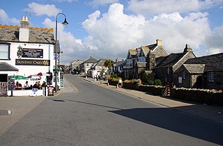
Tintagel or Trevena is a civil parish and village situated on the Atlantic coast of Cornwall, England. The village and nearby Tintagel Castle are associated with the legends surrounding King Arthur and in recent times has become a tourist attraction.

Perranporth is a seaside resort town on the north coast of Cornwall, England, United Kingdom. It is 1 mile east of the St Agnes Heritage Coastline, and around 8 miles south-west of Newquay. Perranporth and its 2 miles (3 km) long beach face the Atlantic Ocean. It has a population of 3,066, and is the largest settlement in the civil parish of Perranzabuloe. It has an electoral ward in its own name, whose population was 4,270 in the 2011 census.

North Cornwall is an area of Cornwall, England, United Kingdom. It is also the name of a former local government district, which was administered from Bodmin and Wadebridge 50.516°N 4.835°W. Other towns in the area are Launceston, Bude, Padstow, and Camelford.

Trevone is a seaside village and bay near Padstow in Cornwall, England, UK.

Abereiddy is a hamlet in the county of Pembrokeshire, in west Wales.

Treknow is a small village in Tintagel civil parish, Cornwall, England, United Kingdom: it is the second largest settlement, and is located between Trevena and Trebarwith. It is situated 19 miles (31 km) north of Bodmin, 4 miles (6.4 km) north-west of Camelford, and 1 mile (1.6 km) west of Tintagel, grid reference SX056869
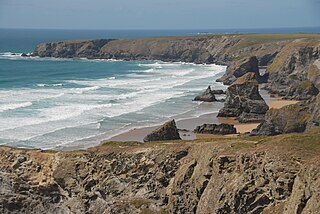
Carnewas and Bedruthan Steps is a stretch of coastline located on the north Cornish coast between Padstow and Newquay, in Cornwall, United Kingdom. It is within the parish of St Eval and is part-owned by the National Trust. The trust maintains a shop and café, and the cliff–top views of rocks stretching into the distance along Bedruthan beach make the area a popular attraction for tourists and painters. The property affords walks along the coast path and the steep steps at Bedruthan allow access to a series of rocky beaches at low tide. Signs at the top of the steps down to the beaches warn visitors not to risk swimming in these waters due to heavy rips, fast tides, and submerged rocks.
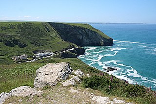
Trebarwith Strand is a section of coastline located near the coastal settlement of Trebarwith on the north coast of Cornwall, England, UK, 2+1⁄2 miles (4.0 km) south of Tintagel. It has 800m of sandy beach contained by cliffs in which natural caves are found. The beach can only be accessed at low tide. The strand was once used to land ships to export slate from the nearby quarries while sand from the beach was used for agricultural purposes. The view from the beach is dominated by rocks 300m offshore known as Gull Rock or Otterham Rocks.

The geology of Cornwall, England, is dominated by its granite backbone, part of the Cornubian batholith, formed during the Variscan orogeny. Around this is an extensive metamorphic aureole formed in the mainly Devonian slates that make up most of the rest of the county. There is an area of sandstone and shale of Carboniferous age in the north east, and the Lizard peninsula is formed of a rare section of uplifted oceanic crust.
Stepper Point is a headland on the Atlantic coast in north Cornwall, England, United Kingdom. It is at grid reference SW911781. Stepper Point and Pentire Point stand at either side of the mouth of the River Camel; Stepper to the south-west, Pentire to the north-east.
Gillow State Quarry is a small, disused slate quarry between Tintagel and Trebarwith on the north coast of Cornwall, South West England. The quarry was abandoned by the turn of the 20th century.
Long Grass Quarry is a small, disused slate quarry between Tintagel and Trebarwith on the north coast of Cornwall, South West England, which was worked up until 1937. It was the last of the slate quarries on this stretch of coast to be abandoned.
Lambshouse and Gull Point Quarries are two disused slate quarries between Tintagel and Trebarwith at Lambshouse Cove on the north coast of Cornwall, South West England. The quarries were latterly worked jointly as one site and were abandoned by the turn of the 20th century. It is likely that Lambshouse Quarry originated at the cliffs at the north of the cove while Gull Point was to the south.
Bagalow Quarry is a disused slate quarry between Tintagel and Trebarwith at Bagalow Cove on the north coast of Cornwall, South West England. The quarry was worked from the 1830s into the early part of the twentieth century.
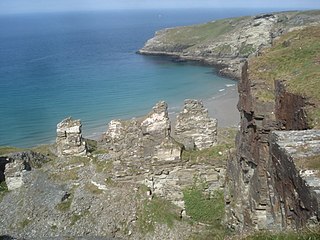
Tintagel Slate Quarries fall into two categories: the series of quarries lying between Tintagel Castle and Trebarwith Strand on the north coast of Cornwall, South West England and the open cast quarries further inland. There are around eight cliff-edge quarries as well as two wharfs, all of which are now disused as well as four inland sites, two of which are still in operation. The first quarry to be worked appears to have been Lanterdan at some point in the fifteenth century, while the last of the coastal quarries, Long Grass ceased operations in 1937. The remains of the coastal quarries occupy coastal land owned by the National Trust and most are easily accessible from the South West Coast Path. The Prince of Wales Quarry has been turned into a country park by North Cornwall District Council.
Bowithick Quarry is a disused nineteenth century open cast slate quarry situated in Trebarwith Valley on the outskirts of Tintagel in Cornwall, South West England. The quarry ceased operations in 1913.
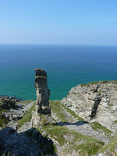
Lanterdan Quarry is a disused open cast slate quarry between Tintagel and Trebarwith on the north coast of Cornwall, South West England. The quarry is the oldest, largest and most spectacular of Tintagel’s coastal quarries and was worked from the fifteenth until the early twentieth century. A distinguishing feature of the quarry is a 25m high pinnacle of inferior slate.

Tintagel Haven also known as Castle Cove is a small beach on the north side of Tintagel Island on the north coast of Cornwall, South West England.
Penhallick Wharf is a disused coastal loading dock between Tintagel Castle and Trebarwith Strand on the north coast of Cornwall in South West England. The wharf served the Tintagel Slate Quarries, particularly those without easy access to the loading beach at Tintagel Haven. These include Caroline, Dria, Bagalow and possibly Lambshouse and Gull Point quarries.
West Quarry is a disused open cast slate quarry between Tintagel and Trebarwith on the north coast of Cornwall, South West England. The quarry ceased operations towards the end of the nineteenth century.
