Nyhavn is a 17th-century waterfront, canal and entertainment district in Copenhagen, Denmark. Stretching from Kongens Nytorv to the Inner Harbour just south of the Royal Playhouse, it is lined by brightly coloured 17th and early 18th century townhouses and bars, cafes and restaurants. The canal harbours many historical wooden ships.

Naval Station Holmen is one of several naval stations of the Royal Danish Navy, supplementing the two Danish naval bases in Frederikshavn and Korsør.

The Holmen Church is a Parish church in central Copenhagen in Denmark, on the street called Holmens Kanal. First built as an anchor forge in 1563, it was converted into a naval church by Christian IV. It is famous for having hosted the wedding between Margrethe II of Denmark, queen of Denmark between 1972 and 2024, and Prince Henrik in 1967. It is the burial site of such notabilities as naval heroes Niels Juel and Peter Tordenskjold, and composer Niels Wilhelm Gade, and contains artwork by, among others, Bertel Thorvaldsen and Karel van Mander.

Langebro is a bascule bridge across the Inner Harbour of Copenhagen, Denmark, connecting Zealandside H. C. Andersens Boulevard to Amagerside Amager Boulevard. It is one of only two bridges to carry motor vehicles across the harbour in central Copenhagen, the other being Knippelsbro.
Gammelholm is a predominantly residential neighbourhood in the city centre of Copenhagen, Denmark. It is bounded by the Nyhavn canal, Kongens Nytorv, Holmens Kanal, Niels Juels Gade and the waterfront along Havnegade. For centuries, the area was the site of the Royal Naval Shipyard, known as Bremerholm, but after the naval activities relocated to Nyholm, it came under residential redevelopment in the 1860s and 1870s. The new neighbourhood was planned by Ferdinand Meldahl and has also been referred to as "Meldahl's Nine Streets". Apart from the buildings which face Kongens Nytorv, which include the Royal Danish Theatre and Charlottenborg Palace, the area is characterized by homogeneous Historicist architecture consisting of perimeter blocks with richly decorated house fronts.

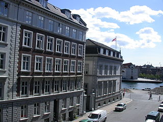
Sankt Annæ Plads is a public square which marks the border between the Nyhavn area and Frederiksstaden neighborhoods of central Copenhagen, Denmark. It is a long narrow rectangle which extends inland from the waterfront, at a point just north of the Royal Danish Playhouse at the base of the Kvæsthus Pier, now known as Ofelia Plads, until it meets Bredgade. A major renovation of the square was completed in 2016.The Garrison Church is located on the south side of the square. Amaliegade, one of the two axes on which Frederiksstaden is centered, extends from the square.

Vester Voldgade is a street in Copenhagen, Denmark which runs from Jarmers Plads to the waterfront between Frederiksholms Kanal and Langebro, passing the City Hall Square on the way.
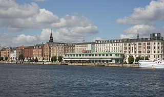
Havnegade is a waterfront promenade in central Copenhagen, Denmark, which runs along the Inner Harbour between Knippelsbro and the mouth of the Nyhavn canal. Most of the street is lined with buildings from the 1860s and 1870s that were constructed as part of the redevelopment of the Gammelholm naval dockyards. It is the only place along Copenhagen's main harbourfront where residential buildings of that age face the water, although older warehouses and other industrial buildings elsewhere have been converted into residential use. The Modernist Bank of Denmark building is located at the western end of the street.
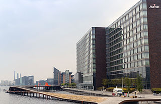
Kalvebod Brygge is a waterfront area in the Vesterbro district of Copenhagen, Denmark. The name also refers to a section of the Ring 2 ring road which follows the waterfront from Langebro in the north to the H. C. Ørsted Power Station in the south. The area is dominated by office buildings, Tivoli Conference Center, several hotels and the shopping centre Fisketorvet.
Ved Stranden is a canal side public space and street which runs along a short section of the Zealand side of Slotsholmen Canal in central Copenhagen, Denmark. It begins at Holmens Kanal, opposite the Church of Holmen, and runs west along the canal for one and a half blocks before widening into a small, triangular space adjacent to Højbro Bridge and Højbro Plads. The name of the street refers to Gammel Strand, 'Old Beach', which it formed part of until 1961.

Torvegade is the central thoroughfare of Christianshavn in Copenhagen, Denmark, linking the city centre by way of Knippel Bridge with Amagerside Copenhagen at Christmas Møllers Plads. The street crosses Christianshavn Canal at Christianshavns Torv, the central square of the neighbourhood. The last section of the street runs on the embankment that across Stadsgraven.

Store Kongensgade is the longest street in central Copenhagen, Denmark. It extends northeast from Kongens Nytorv to Esplanaden, running parallel to Bredgade, where it breaks left, continuing northwest to Grønningen.

Stockholmsgade is a mainly residential street in central Copenhagen, Denmark. It follows the northwestern margin of Østre Anlæg, linking Sølvtorvet in the southwest with Oslo Plads at Østerport station in the northeast. The Hirschsprung Collection, an art museum, is located on the street.

Slotsholmsgade is a street which runs along the rear side of Børsen on Slotsholmen in central Copenhagen, Denmark. Located next to the Danish parliament building Christiansborg, most of the buildings in the street house government offices. Several of them date from the 17th and 18th century and are listed.

Grøns Pakhus is a former warehouse and retail establishment located on Holmens Kanal in the Gammelholm neighbourhood of central Copenhagen, Denmark. Opened by M.E. Grøn & Søn in 1863, it heralded the arrival of proper department stores in Denmark with the opening of Magasin du Nord a few years later. The Historicist building was designed by Johan Daniel Herholdt. The building was listed in 1979 and declared an Industrial Heritage Site in 2009.

The Statue of Niels Juel, created by the sculptor Theobald Stein, was unveiled in 1881 at Holmens Kanal in Copenhagen, Denmark. It stands next to Church of Holmen where he is buried and close to his former home in Kongens Nytorv. The monument with surroundings was listed in 2004.

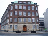
The Peschier House is a listed property at Holmens Kanal in the Old Town of Copenhagen, Denmark. The building is currently part of Danske Bank's headquarters but it has been sold to Standard Life and the bank has announced its plans to move to new premises close to Copenhagen Central Station.

Christians Brygge is a waterfront and street in central Copenhagen, Denmark. It runs from the mouth of Slotsholmen Canal in the north to Langebro Bridge in the south where it turns into Kalvebod Brygge. Its northern end, which is located on the small isle of Slotsholmen, is connected to Niels Juels Gade and then Holmens Kanal by Christian IV's Bridge. Christians Brygge The road section is part of Ring 2. The name refers to Christian IV, king of Denmark during the first half of the 17th century, who constructed several buildings at the site, including the Arsenal and Christian IV's Brewhouse as well as nearby Børsen. Other landmarks along the quay include the Royal Danish Library and the mixed-use building BLOX, home to the Danish Architecture Centre.

Christmas Møllers Plads is a major junction located in front of the embankment to Christianshavn on northern Amager in Copenhagen, Denmark. It links Torvegade, the main thoroughfare of Christianshavn, with Vermlandsgade, Amagerbrogade, Amagerfælledvej and Ved Stadsgraven-Amager Boulevard. Its name commemorates the Conservative politician Christmas Møller who had been active in the resistance movement during World War II and later served as Minister of Foreign Affairs.

Niels Juels Gade is a street in Indre By, Copenhagen, which runs from Holmens Kanal to Havnegade. The street is an extension of Christian IV's Bro to Christians Brygge and together with them forms part of Ring 2. Along the entire southern side of the street is Danmarks Nationalbank. On the northern side, there are a number of apartment buildings, which are primarily used for business. Furthermore, the Nigerien embassy is located in the street. The street is named after the naval hero Niels Juel (1629-1697).