Related Research Articles

For administrative purposes, Papua New Guinea is divided into administrative divisions called provinces. There are 22 provincial-level divisions, which include 20 provinces, the Autonomous Region of Bougainville, and the National Capital District of Port Moresby.
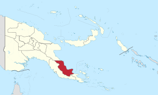
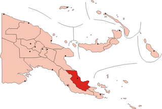
Oro Province, formerly Northern Province, is a coastal province in the Southern Region of Papua New Guinea. The provincial capital is Popondetta. The province covers 22,800 km2, and has 176,206 inhabitants. The province shares land borders with Morobe Province to the northwest, Central Province to the west and south, and Milne Bay Province to the southeast. The province is located within the Papuan Peninsula.

The Anglican Church of Papua New Guinea is a province of the Anglican Communion. It was created in 1977 when the Province of Papua New Guinea became independent from the Province of Queensland in the Church of England in Australia following Papua New Guinea's independence in 1975.

Mambare River is a river in Oro Province, Papua New Guinea, located at 8.05°S 148.0333333°E.
Oro Bay is a bay in Oro Province, Papua New Guinea, located 15 miles (24 km) southeast of Buna. The bay is located within the larger Dyke Ackland Bay. A port is operated by PNG Ports Corporation Limited with limited wharf facilities, located at 8°53′47″S148°29′39″E.

Cape Sudest is a cape in Papua New Guinea, next to Oro Bay. Cape Sudest is a remote and rugged peninsula located in the southeastern part of Papua New Guinea. It is situated in the Ijivitari District of the Milne Bay Province, which is one of the 22 provinces of Papua New Guinea. The Cape Sudest peninsula is surrounded by the Solomon Sea on the east and the Coral Sea on the south, and it is characterized by steep cliffs, dense rainforests, and pristine beaches.

The Musa is a river on the eastern side of the Papuan Peninsula, in Papua New Guinea. It is one of the primary rivers on Oro Province. Its mouth exits into Dyke Ackland Bay.
Pongani is a village on the north coast of Papua New Guinea in Dyke Ackland Bay, Oro Province.
The Kumusi River is a river located in the Oro Province of Papua New Guinea. Known for its width and its strength, the Kumusi has had a significant impact on the history of the Oro Province. It was a significant factor in the Kokoda Track Campaign and also a contributing factor to the destruction caused by Cyclone Guba.
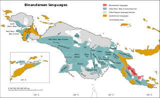
The Greater Binanderean or Guhu-Oro languages are a language family spoken along the northeast coast of the Papuan Peninsula – the "Bird's Tail" of New Guinea – and appear to be a recent expansion from the north. They were classified as a branch of the Trans–New Guinea languages by Stephen Wurm (1975) and Malcolm Ross (2005), but removed by Timothy Usher (2020). The Binandere family proper is transparently valid; Ross connected it to the Guhu-Semane isolate based on pronominal evidence, and this has been confirmed by Smallhorn (2011). Proto-Binanderean has been reconstructed in Smallhorn (2011).
Gona is a coastal village in Oro Province, Papua New Guinea.
Sanananda is a village on the coast of Oro Province, Papua New Guinea.
Dyke Ackland Bay is a large bay in the Oro Province of Papua New Guinea. The bay extends from Cape Nelson to Cape Ward Hunt. Porlock Bay and Oro Bay are some of the smaller bays located within the larger bay. The bay was named by Captain John Moresby after his friend Sir Thomas Dyke Acland.
Ijivitari District is a district of the Oro Province of Papua New Guinea. Its capital is Popondetta. The population was 99,762 at the 2011 census.
Mountain Koiari (Koiali) is a language of Oro Province and Central Province, Papua New Guinea. It is not very similar to the other language which shares its name, Grass Koiari. Half of its speakers are monolingual.
Nawaru, or Sirio, is a Papuan language. It is spoken in the village of Sibia in Namudi ward, Safia Rural LLG, Ijivitari District, Oro Province, in the "tail" of Papua New Guinea.
Namiae is a Koiarian language of Oro Province, Papua New Guinea.
Barai is a Koiarian language spoken in Oro Province of Papua New Guinea.
The Girua River is a river located in the Oro Province of Papua New Guinea.
Nauna is an Oceanic language spoken in the single village of Nauna on Nauna Island in Rapatona Rural LLG, Manus Province, Papua New Guinea.
References
- ↑ "Pacific Wrecks - Holnicote Bay (Gona Bay) Oro Province, Papua New Guinea (PNG)". pacificwrecks.com. Retrieved 21 March 2024.
8°35′00″S148°20′00″E / 8.5833333°S 148.3333333°E
| | This Papua New Guinea–related geography article is a stub. You can help Wikipedia by expanding it. |