Related Research Articles

Orange Walk Town is the fourth largest town in Belize, with a population of about 13,400. It is the capital of the Orange Walk District. Orange Walk Town is located on the left bank of the New River, 53 miles (85 km) north of Belize City and 30 miles (48 km) south of Corozal Town. Despite the English name of the city, its residents are primarily Spanish-speaking mestizos.

Lamanai is a Mesoamerican archaeological site, and was once a major city of the Maya civilization, located in the north of Belize, in Orange Walk District. The site's name is pre-Columbian, recorded by early Spanish missionaries, and documented over a millennium earlier in Maya inscriptions as Lam'an'ain. Lamanai is renowned for its exceptionally long occupation spanning three millennia, beginning in the Early Preclassic Maya period and continuing through the Spanish and British Colonial periods, into the 20th century. Unlike most Classic-period sites in the southern Maya lowlands, Lamanai was not abandoned at the end of the 10th century AD.
Sacrifice was a religious activity in Maya culture, involving the killing of humans or animals, or bloodletting by members of the community, in rituals superintended by priests. Sacrifice has been a feature of almost all pre-modern societies at some stage of their development and for broadly the same reason: to propitiate or fulfill a perceived obligation towards the gods.

The Maya Biosphere Reserve is a nature reserve in Guatemala managed by Guatemala's National Council of Protected Areas (CONAP). The Maya Biosphere Reserve covers an area of 21,602 km2, one-fifth of the country's total land area.

Trade was a crucial factor in maintaining Maya cities.
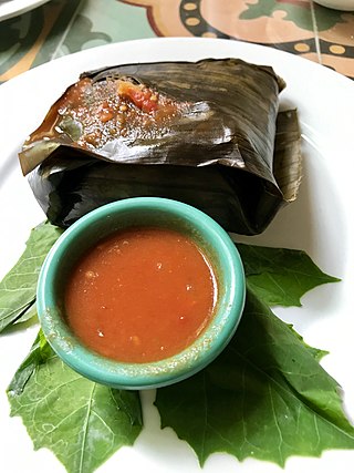
Ancient Maya cuisine was varied and extensive. Many different types of resources were consumed, including maritime, flora, and faunal material, and food was obtained or produced through strategies such as hunting, foraging, and large-scale agricultural production. Plant domestication concentrated upon several core foods, the most important of which was maize.
Stephen Douglas Houston is an American anthropologist, archaeologist, epigrapher, and Mayanist scholar, who is particularly renowned for his research into the pre-Columbian Maya civilization of Mesoamerica. He is the author of a number of papers and books concerning topics such as the Maya script, the history, kingships and dynastic politics of the pre-Columbian Maya, and archaeological reports on several Maya archaeological sites, particularly Dos Pilas and El Zotz. In 2021, National Geographic noted that he participated in the correct cultural association assigned to a half-size replica discovered at the Tikal site of the six-story pyramid of the mighty Teotihuacan culture, which replicated its Citadel that includes the original Feathered Serpent Pyramid.

Copper Bank is a fishing village in the Corozal District of Belize. It is situated on the west bank of Laguna Seca, a shallow lagoon that empties into Chetumal Bay just north-east of the village. The closest settlement is Chunox, located approximately 1.25 miles away on the east bank of the Laguna Seca.

The Pre-Columbian Belize history is the period from initial indigenous presence, across millennia, to the first contacts with Europeans - the Pre-Columbian or before Columbus period - that occurred on the region of the Yucatán Peninsula that is present day Belize.

The history of Belize dates back thousands of years. The Maya civilization spread into the area of Belize between 1500 BC to 1200 BC and flourished until about 1000 AD. Several Maya ruin sites, including Cahal Pech, Caracol, Lamanai, Lubaantun, Altun Ha, and Xunantunich reflect the advanced civilization and much denser population of that period. The first recorded European incursions in the region were made by Spanish conquistadors and missionaries in the 16th century. One attraction of the area was the availability of logwood, which also brought British settlers.

Santa Rita is a Maya ruin and an archaeological reserve on the outskirts of Corozal, Belize. Historical evidence suggests that it was probably the ancient and important Maya city known as Chetumal.

Arlen F. Chase is a Mesoamerican archaeologist and a faculty member in the anthropology department at Pomona College, Claremont CA. Previously, he was a professor at the University of Nevada, Las Vegas and served a variety of administrative roles at the University of Central Florida over the course of his 32 year stay at that institution. He is noted for his long-term research at the ancient Maya city of Caracol, Belize and for exploring landscape traces of Maya civilization using lidar.
Colha, Belize is a Maya archaeological site located in northern portion of the country, about 52 km. north of Belize City, near the town of Orange Walk. The site is one of the earliest in the Maya region and remains important to the archaeological record of the Maya culture well into the Postclassic Period. According to Palma Buttles, “Archaeological evidence from Colha allows for the interpretation occupation from the Early Preceramic (3400-1900B.C.) to Middle Postclassic with population peaks occurring in the Late Preclassic and again in the Late Classic ”. These peaks in population are directly related to the presence of stone tool workshops at the site. Colha's proximity to an important source of high quality chert that is found in the Cenozoic limestone of the region and well traveled trade routes was utilized by the inhabitants to develop a niche in the Maya trade market that may have extended to the Greater Antilles. During the Late Preclassic and Late Classic periods, Colha served as a primary supplier of worked stone tools for the region. It has been estimated that the 36 workshops at Colha produced nearly 4 million chert and obsidian tools and eccentrics that were dispersed throughout Mesoamerica during the Maya era. This made it an important player in the trade of essential good throughout the area.
Baking Pot is a Maya archaeological site located in the Belize River Valley on the southern bank of the river, northeast of modern-day town of San Ignacio in the Cayo District of Belize; it is 6 kilometres (3.7 mi) downstream from the Barton Ramie and Lower Dover archaeological sites. Baking Pot is associated with an extensive amount of research into Maya settlements, community-based archaeology, and of agricultural production; the site possesses lithic workshops, and possible evidence of cash-cropping cacao as well as a long occupation from the Preclassic through to the Postclassic period.
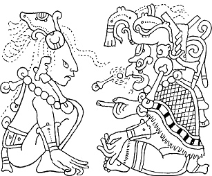
The extensive trade networks of the Ancient Maya contributed largely to the success of their civilization spanning three millennia. Maya royal control and the wide distribution of foreign and domestic commodities for both population sustenance and social affluence are hallmarks of the Maya visible throughout much of the iconography found in the archaeological record. In particular, moderately long-distance trade of foreign commodities from the Caribbean and Gulf Coasts provided the larger inland Maya cities with the resources they needed to sustain settled population levels in the several thousands. Though the ruling class essentially controlled the trade economy, a middle merchant class supervised import and export from cities and trade ports. Not much is known of the Maya merchant class; however, merchants of royal lineage are sometimes represented in the iconography. Notably, a canoe paddle often accompanies the royal merchant depictions, signifying their association with marine resources.
The history of Maya civilization is divided into three principal periods: the Preclassic, Classic and Postclassic periods; these were preceded by the Archaic Period, which saw the first settled villages and early developments in agriculture. Modern scholars regard these periods as arbitrary divisions of chronology of the Maya civilization, rather than indicative of cultural evolution or decadence. Definitions of the start and end dates of period spans can vary by as much as a century, depending on the author. The Preclassic lasted from approximately 3000 BC to approximately 250 AD; this was followed by the Classic, from 250 AD to roughly 950 AD, then by the Postclassic, from 950 AD to the middle of the 16th century. Each period is further subdivided:
Marilyn Masson is a Maya archaeologist whose research has focused on social transformation and political economy of ancient Mesoamerican cultures in Mexico and Belize. She is a professor of Mesoamerican archaeology at the University at Albany, SUNY. She is a co-director of the PEMY project at the site of Mayapan in the Northern Yucutan Peninsula of Mexico.
Elizabeth Graham is a professor of Mesoamerican Archaeology at UCL. She has worked, for decades, on the Maya civilization, both in prehispanic and colonial times, specifically in Belize. She has recently turned her attention to Maya Dark Earths, and conducts pioneering work in the maya region as dark earths have mostly been studied in the Amazonia. She particularly focuses on how human occupation influences soil formation and production.
David Freidel is a U.S. archaeologist who studies the ancient Maya. He is known for his research at El Perú-Waka’ and his books with epigrapher Linda Schele. He is currently a professor at Washington University in St. Louis.

Chetumal, or the Province of Chetumal, was a Postclassic Maya state of the Yucatan Peninsula, in the Maya Lowlands.
References
- Masson, M. A.(2014). In the Realm of Nachan Kan: Postclassic Maya Archaeology at Laguna De On, Belize. Boulder: University Press of Colorado. Retrieved September 17, 2016, from Project MUSE database.
- Masson, M. A. (1997). Cultural Transformation at the Maya Postclassic Community of Laguna de On, Belize. Latin American Antiquity, 8(4), 293. doi:10.2307/972105 Retrieved September 17, 2016
- Belize's Island Maya. (1997, January). Earthwatch: The Journal of Earthwatch Institute, 16(1), 1-31. Retrieved September 17, 2016.
- Honey Camp Ranch. (2013). Retrieved September 17, 2016, from https://www.travelbelize.org/honey-camp-ranch Archived 2016-10-22 at the Wayback Machine
- Northern Belize - Honey Camp Lagoon of the Orange Walk District, Belize. (n.d.). Retrieved September 17, 2016, from http://www.northernbelize.com/see_hclagoon.html
- Honey Camp Ranch About. (n.d.). Retrieved September 17, 2016, from http://honeycampranch.com/hcA.htm Archived 2016-09-18 at the Wayback Machine
- 5 Must-Dos in Orange Walk. (n.d.). Retrieved September 17, 2016, from https://belizetourismboard.org/works/5-must-dos-in-orange-walk/
| | This Belize-related article is a stub. You can help Wikipedia by expanding it. |