Hawaiʻi County is a county in the U.S. state of Hawaii in the Hawaiian Islands. It is coterminous with the Island of Hawaiʻi, often called the "Big Island" to distinguish it from the state as a whole. As of the 2010 Census the population was 185,079. The county seat is Hilo. There are no incorporated cities in Hawaiʻi County. The Hilo Micropolitan Statistical Area includes all of Hawaiʻi County. Hawaiʻi County has a mayor-council form of government. Hawaii County is the largest county in the state in terms of geography.

Pahala is a census-designated place (CDP) in Hawaii County, Hawaii, United States. The population was 1,356 at the 2010 census.
The Wailuku River is a 28.0-mile-long (45.1 km) water course on the Island of Hawaiʻi in the Hawaiian Islands. It is the longest river in Hawai'i and its course lies mostly along the divide between the lava flows of Mauna Kea and those of Mauna Loa to the south. It arises at about the 10,800 feet (3,300 m) elevation along the eastern slope of Mauna Kea. It flows generally eastward, descending steeply from the mountain and entering the Pacific Ocean at Hilo.

Prince Albert Kamehameha, formally Albert Edward Kauikeaouli Kaleiopapa a Kamehameha, was the only son of Kamehameha IV and Queen Emma, who during his short life was the Crown Prince of the Kingdom of Hawaiʻi. He was the godson of Queen Victoria.

Ingram Macklin Stainback was an American politician. He served as the ninth Territorial Governor of Hawaii from 1942 to 1951.
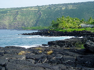
Punaluʻu Beach is a beach between Pāhala and Nāʻālehu on the Big Island of the U.S. state of Hawaii. The beach has black sand made of basalt and created by lava flowing into the ocean which explodes as it reaches the ocean and cools. This volcanic activity is in the Hawaiʻi Volcanoes National Park. Punaluʻu is frequented by endangered hawksbill and green turtles, which can often be seen basking on the black sand.
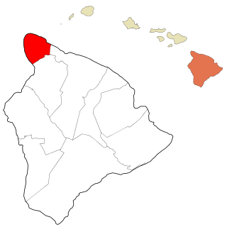
Kohala is the name of the northwest portion of the island of Hawaiʻi in the Hawaiian Archipelago. In ancient Hawaii it was often ruled by an independent High Chief called the Aliʻi Nui. In modern times it is divided into two districts of Hawaii County: North Kohala and South Kohala. Locals commonly use the name Kohala to refer to the census-designated places of Halaʻula, Hāwī, and Kapaʻau collectively. The dry western shore is commonly known as the Kohala Coast, which has golf courses and seaside resorts.

Route 200, known locally as Saddle Road, traverses the width of the Island of Hawaiʻi, from downtown Hilo to its junction with Hawaii Route 190 near Waimea. The road was once considered one of the most dangerous paved roads in the state, with many one-lane bridges and areas of marginally maintained pavement. Most of the road has now been repaved, and major parts have new re-alignments to modern standards. The highway is mostly one-lane in each direction, but there are two lanes on the uphill portions. The highway reaches a maximum elevation of 6,632 feet (2,021 m) and is subject to fog and low visibility. Many rental car companies used to prohibit use of their cars on Saddle Road, but now allow use of the road. The highway experiences heavy use as it provides the shortest driving route from Hilo to Kailua-Kona and access to the slopes of Mauna Loa and the Mauna Kea Observatories.
Waiākea is an ancient subdivision (ahupuaʻa) in the Hilo District of the Big Island of Hawaiʻi and an early settlement on Hilo Bay.

Hakalau is a small unincorporated community located along the Hamakua coast about 15 miles (24 km) north of Hilo on the Big Island of Hawaii in the U.S. state of Hawaii at 19°53′49″N155°7′35″W.
Kēōkea is an unincorporated populated place in Hawaii County, Hawaii, United States. It is located at 19°25′10″N155°52′58″W, near the junction of Māmalahoa Highway and Keala o Keawe Road, elevation 960 feet. Satellite imagery shows evidence of a humid climate with agriculture dominant around the settlement. Just to the north is the area of Hōnaunau. It was the name for the land division (ahupuaa) of ancient Hawaii that stretched from the shoreline to Mauna Loa owned by Mataio Kekūanāoa.
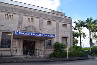
The Pacific Tsunami Museum is a museum in Hilo, Hawaii dedicated to the history of the April 1, 1946 Pacific tsunami and the May 23, 1960 Chilean tsunami which devastated much of the east coast of the Big Island, especially Hilo. The museum also has a mission to educate people in general about tsunamis, including the 2004 Indian Ocean earthquake and tsunami. It is located at 130 Kamehameha Avenue, Hilo, coordinates 19°43′33″N155°5′12″W.
The University of Hawaiʻi at Hilo Botanical Gardens are botanical gardens on the University of Hawaiʻi at Hilo campus, located at 200 West Kawili Street, Hilo, Hawaiʻi on the island of Hawaiʻi. They are open daily without charge.

Mauna Loa Macadamia Nut Corporation is the world's largest processor of macadamia seeds. The American company was a subsidiary of The Hershey Company from 2004 to 2015, when it was acquired by Hawaiian Host, Inc. The company takes its name from the volcano Mauna Loa. Their headquarters and main processing plant are near the mountain, south of Hilo in the Puna District of the island of Hawaiʻi, known as the Big Island.

Kolekole Beach Park is a Hawaii county park on the island of Hawaii. As of April 2017, it is currently closed due to lead contamination found in the soil of the lawn areas. It will remain closed as further testing is done.

Hilo Bay is a large bay located on the eastern coast of the island of Hawaiʻi.
Kona is a moku or district on the Big Island of Hawaiʻi in the State of Hawaii. In the current system of administration of Hawaiʻi County, the moku of Kona is divided into North Kona District and South Kona District. The term "Kona" is sometimes used inaccurately to refer to its largest town, Kailua-Kona. Other towns in Kona include Kealakekua, Keauhou, Holualoa, Hōnaunau and Honalo.
19.634622°N 155.0885967°WLower Waiakea Mountain Bicycle Park is the state of Hawai‘i's first bicycle park created by Big Island Mountain Biking Association.

Hōlei Sea Arch is a 90-foot (27-meter)-high natural arch located in Hawaii, on the southern coast of the Big Island, south of Kīlauea. This rock formation was born from marine erosion, in which the waves of the Pacific Ocean create this natural bridge of lava cliffs. The arch is made of basalt. It takes its name from the Hōlei Pali, the escarpment located up on the slopes of the volcano.