Hope Street is a major two lane bidirectional street running about three miles north to south on the East Side of Providence, Rhode Island. The street serves as a main artery serving most of the East Side district and connects the East Side to Pawtucket at the north, where it continues as East Avenue.
It intersects with other important streets on the East Side including Blackstone Boulevard, Waterman Street, Angell Street, Thayer Street, and Wickenden Street. Unlike many major city arteries, Hope Street is predominantly residential, and most of the local stores and offices are located on other streets that branch off. Small areas, like the Hope Street Village, house local business and restaurants.[1] Hope Street also runs through the eastern side of Brown University's campus. Hope High School (Rhode Island) is located on the street.
Almost all of Hope Street is serviced by RIPTA's route 1 (formerly 42), which provides transit services between Pawtucket and Downtown Providence.[2]
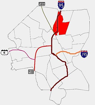
Route 114 is a 45.7-mile-long (73.5 km) numbered state highway in the U.S. state of Rhode Island. It connects the city of Newport to the city of Woonsocket. Route 114 was a major north–south artery for its entire length until the arrival of the Interstate Highway System. It is still a major commercial corridor on Aquidneck Island and in northern Rhode Island.
Cowesett is a hillside neighborhood located in Warwick, Rhode Island.
Blackstone is a predominantly residential neighborhood in Providence, Rhode Island. It is in the northeast corner of the city and is bounded to the south and west by Lloyd Avenue and Hope Street respectively. It is one of six neighborhoods comprising the East Side of Providence.
Fox Point is a neighborhood in the East Side of Providence, Rhode Island. It is bounded by the Providence and Seekonk rivers, Interstate 195 and the College Hill and Wayland neighborhoods. Fox Point is the southernmost neighborhood in the East Side area of Providence.
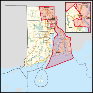
Rhode Island's 1st congressional district is a congressional district in the U.S. state of Rhode Island. It includes all of Bristol and Newport counties, along with parts of Providence County, including most of the city of Providence.
The Rhode Island Historical Society is a privately endowed membership organization, founded in 1822, dedicated to collecting, preserving, and sharing the history of Rhode Island. Its offices are located in Providence, Rhode Island.
The East Side is a collection of neighborhoods in the eastern part of the city of Providence, Rhode Island. It officially comprises the neighborhoods of Blackstone, Hope, Mount Hope, College Hill, Wayland, and Fox Point.
Forestdale is a village and historic district in North Smithfield, Providence County, Rhode Island, United States, one-half mile from Slatersville, Rhode Island. The historic district runs east and west along Main Street and north on Maple Avenue. School Street is the primary road through the village, and the one-room schoolhouse for which the street is named still stands. The Branch River runs through the valley adjacent to the School Street. The Village Haven Restaurant and local VFW chapter are also located in the village.
The South Side of Providence, Rhode Island, originally South Providence, is a term frequently used to describe the collective region comprising the official neighborhoods of Upper and Lower South Providence, Elmwood and the West End. The name was first used in the 1830s when the New York, Providence and Boston Railroad established its first station at a pier on the Providence River on a point of land about one half mile south of downtown Providence. The station was named South Providence.
Hope is a neighborhood on the northern border of Providence, Rhode Island. To the west, it is bounded by North Main Street, the North Burial Ground, and Interstate 95, while Rochambeau Ave, Hope Street, and the Providence-Pawtucket city line roughly delineate its boundaries to the south, east, and north respectively. Hope is sometimes referred to as "Summit", named for the street that runs through the middle of the neighborhood. Though "Hope" is officially recognized, residents and the local neighborhood organization more often use "Summit".
Mount Hope is a neighborhood in northern Providence, Rhode Island. It is one of six neighborhoods comprising the East Side of Providence. The area is bounded to the north by Rochambeau Avenue, to the east by Hope Street, to the south by Olney Street, while the western border is the former New York-New Haven Railroad and Interstate 95.
Pawtucket/Central Falls station is a commuter rail station in Pawtucket, Rhode Island. It opened for MBTA Commuter Rail Providence/Stoughton Line service on January 23, 2023. The station has two side platforms serving the two tracks of the Northeast Corridor. It is also a hub for RIPTA local bus service.
Lonsdale is a village and historic district in Lincoln and Cumberland, Providence County, Rhode Island, United States, near Rhode Island Route 146 and Route 95. The village was originally part of the town of Smithfield until Lincoln was created in the 1870s, and was originally centered on the Lincoln side of the Blackstone River. William Blaxton settled in the area in 1635. In the nineteenth and early twentieth centuries, Lonsdale was home to several manufacturers including the Lonsdale Company's Bleachery, and the Ann & Hope mill was also located in the village in Cumberland.
Wickenden Street in Fox Point, Providence, Rhode Island is a popular destination for students of the area's colleges and schools. The street is surrounded by schools and universities on the East Side of Providence's College Hill, including Brown University, RISD, Moses Brown School, & The Wheeler School.
The Wayland Historic District is a predominantly residential historic district on the east side of Providence, Rhode Island. It is a large area, covering about 122 acres (49 ha), bounded roughly on the north by Everett and Laurel Avenues, on the east by Blackstone Boulevard and Butler Avenue, on the west by Arlington Avenue, and on the south by Angell and South Angell Streets. This area, which was in the 19th century part of the Moses Brown farm, was platted for development in 1891, with most of the construction taking place in the early decades of the 20th century. Most of the residential properties in the district are single-family houses, typically built in revival styles popular at the time. They are set on similarly sized lots with fairly uniform setbacks, and were typically built without garages. There are a number of two-family houses, and a small number of apartment buildings, most of which are found on the arterial roads of the area. There are several religious buildings, including several churches; the most architecturally distinctive religious building is the Jewish Temple Beth El, built 1951–54.
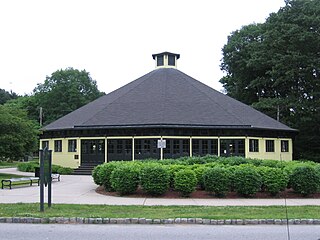
The Looff Carousel in Pawtucket, Rhode Island is a historic carousel which was built in 1895 by Charles I. D. Looff. The carousel was originally located in a carnival called Lee Funland in upstate, New York. The carousel was relocated to its present location at Slater Park in 1910 where it continues to operate.
The R-Line is a Rapid Bus service in Rhode Island, United States, running from Pawtucket to Cranston via downtown Providence. This route was a combination of the old routes 11 and 99. Operated by the Rhode Island Public Transit Authority (RIPTA), it is the agency's first rapid bus route, and the second such system to open in New England. After several years of planning and construction, R-Line service began on June 21, 2014.
Angell Street is a major one-way thoroughfare on the East Side of Providence, Rhode Island. It was named for Thomas Angell, an early settler in Providence.
This page is based on this Wikipedia article Text is available under the CC BY-SA 4.0 license; additional terms may apply. Images, videos and audio are available under their respective licenses.