
Smøla is a municipality in Møre og Romsdal county, Norway. It is part of the Nordmøre region. The administrative centre of the municipality is the village of Hopen, other villages include Dyrnes, Råket, and Veiholmen.

Nordmøre is a traditional district in the Norwegian county of Møre og Romsdal. The 5,426-square-kilometre (2,095 sq mi) area comprises the northern third of the county including the municipalities of Kristiansund, Averøy, Tingvoll, Surnadal, Aure, Halsa, Eide, Sunndal, Gjemnes, and Smøla. The only town in Nordmøre is Kristiansund

Brattvær is a former municipality in Møre og Romsdal county, Norway. The 73-square-kilometre (28 sq mi) municipality existed from 1915 until its dissolution in 1960. It was located on the northwestern part of the island of Smøla in the present-day municipality of Smøla. It included the area surrounding the villages of Råket and Dyrnes as well as the surrounding islets. The Brattvær Church was the main church of the municipality.
Edøy is a former municipality in Møre og Romsdal county, Norway. The municipality existed from 1838 until its dissolution in 1960. It was located in the southern and central parts of the present-day Smøla Municipality. The old municipality originally encompassed all the islands surrounding the Edøyfjorden. This included the islands of Smøla, Tustna, Stabblandet, and the many smaller islands between the larger ones. The island of Edøya lies between the two and that was the center of the old municipality. Over time, parts of Edøy were split off to form other municipalities. At the time it was dissolved, Edøy municipality was 149 square kilometres (58 sq mi). The Old Edøy Church and later the (new) Edøy Church were the main churches for the municipality.

Råket is a village in Smøla Municipality in Møre og Romsdal county, Norway. It is located on the northwestern part of the island of Smøla, just west of the village of Dyrnes. Brattvær Church is located just south of the village.
Veiholmen is a fishing village located on a group of tiny islands in the northern part of Smøla Municipality in Møre og Romsdal county, Norway. The island is located at the end of a 7-kilometre (4.3 mi) long road leading north from the village of Hopen. The road goes over many islands connecting Veiholmen to the island of Smøla to the south. In 2015, the village had the population of 212. Haugjegla Lighthouse is located about 1 kilometre (0.62 mi) north of Veiholmen on a small skerry.

Smøla Wind Farm is a 68 turbine wind farm located in Smøla Municipality in Møre og Romsdal county, Norway. The farm is located southeast of the village of Dyrnes on the island of Smøla. It is operated by Statkraft and covers an area of 18 square kilometres (6.9 sq mi).

The Trondheimsleia is a strait in Møre og Romsdal and Trøndelag counties in Norway. The 94-kilometre (58 mi) long strait runs between the islands of Smøla and Hitra and the mainland municipalities of Aure, Hemne, Snillfjord, and Agdenes. The strait has several fjords which branch off it including the Ramsøyfjorden, Hemnfjorden, and Trondheimsfjorden. The islands of Leksa are located in the Trondheimsleia in Agdenes. The Hitra Tunnel is a road tunnel underneath the Trondheimsleia connecting the island of Hitra to the mainland.
Tranøy or Tranøya may refer to:
Hopen or Höpen may refer to:
Edøy Church is a parish church of the Church of Norway in Smøla Municipality in Møre og Romsdal county, Norway. It is located in the village of Edøy on the southern coast of the island of Smøla. It is the main church for the Edøy parish which is part of the Ytre Nordmøre prosti (deanery) in the Diocese of Møre. The white, wooden church was built in a long church style in 1885 by the architects Jacob Digre and Johan P. Digre. The church seats about 365 people.
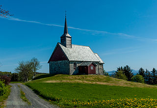
Old Edøy Church is a historic parish church of the Church of Norway in Smøla Municipality in Møre og Romsdal county, Norway. It is located on the southwestern end of the small island of Edøya, just south of the larger island of Smøla. Prior to the construction of the new Edøy Church in 1885, it was the main church for the Edøy parish which is part of the Ytre Nordmøre prosti (deanery) in the Diocese of Møre. The stone church was built in a long church style around the year 1190 by an unknown architect. The church seats about 120 people.

Hopen Church is a parish church of the Church of Norway in Smøla Municipality in Møre og Romsdal county, Norway. It is located in the village of Hopen, along the northern coast of the island of Smøla. It is the church for the Hopen parish which is part of the Ytre Nordmøre prosti (deanery) in the Diocese of Møre. The white, wooden church was built in a long church style in 1892 by the architect Adolph Schirmer. The church seats about 260 people.
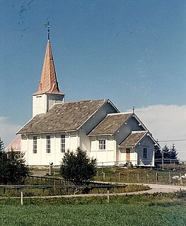
Brattvær Church is a parish church of the Church of Norway in Smøla Municipality in Møre og Romsdal county, Norway. It is located in the tiny hamlet of Brattvær, just south of the larger village of Råket on the western coast of the island of Smøla. It is the church for the Brattvær parish which is part of the Ytre Nordmøre prosti (deanery) in the Diocese of Møre. The white, wooden church was built in a long church style in 1917 by the architect Jakob Parelius Holmgren. The church seats about 420 people.

Edøya is an island in Smøla Municipality in Møre og Romsdal county, Norway. The 7.5-square-kilometre (2.9 sq mi) island lies in the Edøyfjorden between the larger islands of Smøla and Ertvågsøya and Tustna. The island played an important political role during the Viking Age. More recently, it was the center of the old municipality of Edøy and the historic Old Edøy Church is located on the island.

Smøla is the 19th largest island in Norway. The island is located in Smøla Municipality in Møre og Romsdal county, in fact the vast majority of the municipality is the island. The island has a good road network across the island and connecting it to many of the small surrounding islands, however, it does not have any outside road connections to the rest of Norway. The only regular ferry service is via the small island of Edøya to the south of Smøla which one can drive to from Smøla.

Hopen is a former municipality in Møre og Romsdal county, Norway. The 50-square-kilometre (19 sq mi) municipality existed from 1915 until its dissolution in 1960. It covered the northeastern part of the island of Smøla, plus the small islands to the north such as Veiholmen, Hammarøya, and Haugøya. The administrative centre of the municipality was the village of Hopen where the Hopen Church is located.


