
Fort Frederica National Monument, on St. Simons Island, Georgia, preserves the archaeological remnants of a fort and town built by James Oglethorpe between 1736 and 1748 to protect the southern boundary of the British colony of Georgia from Spanish raids. About 630 British troops were stationed at the fort.
There were several historic mills around the metro Atlanta area, for which many of its current-day roads are still named. Most of the mills date back to the 1820s and 1830s, and were built along the area's many streams. The locations of many of these mills are shown on a map of 1875 showing U. S. military operations around Atlanta in 1864. This map is now located in the U. S. Library of Congress but can be seen on the webpage linked here.
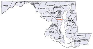
There are more than 1,500 properties and districts listed on the National Register of Historic Places in the U.S. State of Maryland. Each of the state's 23 counties and its one county-equivalent has at least 20 listings on the National Register.

Buildings, sites, districts, and objects in Virginia listed on the National Register of Historic Places:

This is a list of properties and districts in Indiana that are listed on the National Register of Historic Places. There are over 2,000 in total. Of these, 44 are National Historic Landmarks. Each of Indiana's 92 counties has at least two listings.

The Humpback Covered Bridge located in the U.S. state of Virginia, is one of the few remaining covered bridges in the United States that was built higher in the middle than on either end; hence the name of "humpback". The bridge was built in 1857 and is also the oldest remaining covered bridge in the state of Virginia. Its WGCB number is 46-03-01. The bridge spans a tributary of the Jackson River known as Dunlap Creek, for a distance of 109 feet (33 m). The humpback feature is 4 feet (1.2 m) higher in the center than at either end. The bridge is located near the city of Covington, Virginia.

The Bollman Truss Railroad Bridge across the Little Patuxent River at Savage, Maryland, is one of the oldest standing iron railroad bridges in the United States and the sole surviving example of a revolutionary design in the history of American bridge engineering. The 160-foot (48.8 m) double-span was built in 1852 at an unknown location on the main line of the Baltimore and Ohio Railroad. It was moved 35 years later to its present location, where it replaced the very first Bollman bridge. Today, it carries the Savage Mill Trail.

Tunkhannock Creek Viaduct is a concrete deck arch bridge on the Nicholson Cutoff rail line segment of the Norfolk Southern Railway Sunbury Line that spans Tunkhannock Creek in Nicholson, Pennsylvania. Measuring 2,375 feet (724 m) long and towering 240 feet (73.15 m) when measured from the creek bed, it was the largest concrete structure in the world when completed in 1915 and still merited "the title of largest concrete bridge in America, if not the world" 50 years later.

Ebenezer, also known as New Ebenezer, is a ghost town in Effingham County, Georgia, United States, near Ebenezer Creek, on the banks of the Savannah River. It was listed on the U.S. National Register of Historic Places as Ebenezer Townsite and Jerusalem Lutheran Church in 1974.

The Big Rocky Fork Covered Bridge is located 1 mile (1.6 km) southeast of Mansfield, Indiana, on County Road 720 and about 2 miles (3.2 km) east of State Road 59, in Parke County.

The Cogan House Covered Bridge is a Burr arch truss covered bridge over Larrys Creek in Cogan House Township, Lycoming County, in the U.S. state of Pennsylvania. It was built in 1877 and is 94 feet 2 inches (28.7 m) long. The bridge was placed on the National Register of Historic Places in 1980 and underwent a major restoration in 1998. The Cogan House bridge is named for the township and village of Cogan House, and is also known by at least four other names: Buckhorn, Larrys Creek, Day's, and Plankenhorn.

Dunlap's Creek Bridge is the first arch bridge in the United States built of cast iron. It was designed by Richard Delafield and built by the United States Army Corps of Engineers. Constructed from 1836 to 1839 on the National Road in Brownsville, Pennsylvania, it remains in use today. It is listed on the National Register of Historic Places and is a National Historic Civil Engineering Landmark (1978). It is located in the Brownsville Commercial Historic District and supports Market Street, the local main thoroughfare. Due to the steep sides of the Monongahela River valley, there is only room for two short streets parallel to the river's shore and graded mild enough to be comfortable to walk before the terrain rises too steeply for business traffic.

Smithonia is an unincorporated community in Oglethorpe County, Georgia, United States, at the intersection of Crawford-Smithonia and Smithonia Roads. It is also the name of a historical plantation listed on the National Register of Historic Places in 1984.
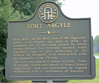
Old Fort Argyle Site is a historic site near Savannah. It is in Fort Stewart in Bryan County, Georgia. It was an English military settlement. It was added to the National Register of Historic Places on March 31, 1975. Access is restricted.

Fort Barrington, briefly renamed Fort Howe after its capture, was a mid-18th-century frontier fort. It was used and garrisoned for several conflicts, including between the British, Spanish, and Native Americans; during the American Revolution; and during the American Civil War. In the years following, much of the original site has been destroyed by river action. Despite this, it was added to the National Register of Historic Places on September 27, 1972, and is currently held as part of a hunting and fishing club. No archaeological work other than ground reconnaissance has been done.
Thomas Creek is a stream, about 35 miles (56 km) long, in Linn County in the U.S. state of Oregon. Beginning in Willamette National Forest on the western slopes of the Cascade Range, the creek flows generally west through Santiam State Forest and farmland to meet the South Santiam River west of Scio.

The Lincoln Highway in Greene County, Iowa is a multiple property submission to the National Register of Historic Places, which was approved on March 29, 1993. It includes five individual listings and five historic districts located in Greene County, Iowa, United States. They encompass abandoned sections of dirt roads, paved sections that are now part of other highways, and various sites, objects, structures and pieces of infrastructure that were a part of the Lincoln Highway. The years of historical significance are 1912 to 1928.
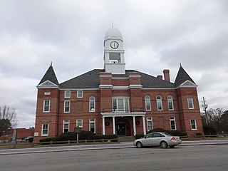
Macon County Courthouse is a historic county courthouse in Oglethorpe, Georgia, county seat of Macon County. It was built in 1894. t is located in Courthouse Square. It is in the Romanesque architecture style. The facade is made of brick. The main portico seems to be a later addition. This entrance has four columns. The clock tower has several stages and contains a bell and a clock. The octagonal dome is topped with a finial. Inside, double stairways lead to the courtroom, which features a Victorian bench. The courthouse was added to the National Register of Historic Places on September 18, 1980.

The Covered Bridge Historic District, in Delaware Township, Hunterdon County, New Jersey, is a 97-acre (39 ha) historic district along County Route 604, Pine Hill Road, and Lower Creek Road. It was listed on the National Register of Historic Places on March 5, 1999, for its significance in architecture, settlement, and transportation. The listing included seven contributing buildings, two contributing structures, and three contributing sites.


