Hozanovići

Last updated
Hozanovići
Village
Bosnia and Herzegovina location map.svg
Red pog.svg
Hozanovići
Coordinates: 44°05′N17°57′E / 44.083°N 17.950°E / 44.083; 17.950
CountryFlag of Bosnia and Herzegovina.svg  Bosnia and Herzegovina
Entity Federation of Bosnia and Herzegovina
Municipality Busovača
Time zone CET (UTC+1)
  Summer (DST) CEST (UTC+2)

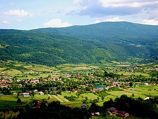
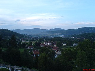
Hozanovići is a village in the municipality of Busovača, Bosnia and Herzegovina. [1]

Village Small clustered human settlement smaller than a town

A village is a clustered human settlement or community, larger than a hamlet but smaller than a town, with a population ranging from a few hundred to a few thousand. Though villages are often located in rural areas, the term urban village is also applied to certain urban neighborhoods. Villages are normally permanent, with fixed dwellings; however, transient villages can occur. Further, the dwellings of a village are fairly close to one another, not scattered broadly over the landscape, as a dispersed settlement.

In Bosnia and Herzegovina the smallest administrative unit is the municipality. Prior to the 1992–95 Bosnian War there were 109 municipalities in what was then Socialist Republic of Bosnia and Herzegovina. Ten of these formed the area of the capital Sarajevo.

Busovača Town and municipality in Federation of Bosnia and Herzegovina, Bosnia and Herzegovina

Busovača is a town and municipality located in Central Bosnia Canton of the Federation of Bosnia and Herzegovina, an entity of Bosnia and Herzegovina. It is located 60 km (37 mi) from Sarajevo, 21 km (13 mi) from Zenica, and 30 km (19 mi) from Travnik.

Related Research Articles

Buljetovina Village in Ilijaš, Bosnia and Herzegovina

Buljetovina is a village in the municipality of Ilijaš, Bosnia and Herzegovina.

Gornja Jurkovica Village in Republika Srpska, Bosnia and Herzegovina

Gornja Jurkovica is a village in the municipality of Gradiška, Republika Srpska, Bosnia and Herzegovina.

Kulen Vakuf Village in Bihać, Bosnia and Herzegovina

Kulen Vakuf is a village in the municipality of Bihać, Bosnia and Herzegovina. Kulen Vakuf was the birthplace of Bosnian Ottoman soldier Mehmed-beg Kulenović. In 6, 7 and 8 September 1941 Kulen Vakuf massacre was made by Yugoslav partisans and Chetniks.

Ripač Village in Bihać, Bosnia and Herzegovina

Ripač is a village in the municipality of Bihać, Bosnia and Herzegovina.

Glavičorak Village in Republika Srpska, Bosnia and Herzegovina

Glavičorak is a village in the municipality of Bijeljina, Republika Srpska, Bosnia and Herzegovina.

Fakovići Village in Republika Srpska, Bosnia and Herzegovina

Fakovići is a village in the municipality of Bratunac, Bosnia and Herzegovina.

Mlečva Village in Republika Srpska, Bosnia and Herzegovina

Mlečva is a village in the municipality of Bratunac, Bosnia and Herzegovina.

Dobraljevo Village in Federation of Bosnia and Herzegovina, Bosnia and Herzegovina

Dobraljevo is a village in the municipality of Busovača, Bosnia and Herzegovina.

Krvavičići Village in Federation of Bosnia and Herzegovina, Bosnia and Herzegovina

Krvavičići is a village in the municipality of Busovača, Bosnia and Herzegovina.

Milavice Village in Federation of Bosnia and Herzegovina, Bosnia and Herzegovina

Milavice is a village in the municipality of Busovača, Bosnia and Herzegovina.

Nezirovići Village in Federation of Bosnia and Herzegovina, Bosnia and Herzegovina

Nezirovići is a village in the municipality of Busovača, Bosnia and Herzegovina.

Kalenderovci Donji Village in Republika Srpska, Bosnia and Herzegovina

Kalenderovci Donji is a village in the municipality of Derventa, Bosnia and Herzegovina.

Fakići Village in Federation of Bosnia and Herzegovina, Bosnia and Herzegovina

Fakići is a village in the municipality of Donji Vakuf, Bosnia and Herzegovina.

Biličić Village in Federation of Bosnia and Herzegovina, Bosnia and Herzegovina

Biličić is a village in the municipality of Glamoč, Bosnia and Herzegovina.

Isakovci Village in Federation of Bosnia and Herzegovina, Bosnia and Herzegovina

Isakovci is a village in the municipality of Glamoč, Bosnia and Herzegovina.

Bičer Village in Kakanj, Bosnia and Herzegovina

Bičer is a village in the municipality of Kakanj, Bosnia and Herzegovina.

Sebinje Village in Kakanj, Bosnia and Herzegovina

Sebinje is a village in the municipality of Kakanj, Bosnia and Herzegovina.

Slapnica Village in Kakanj, Bosnia and Herzegovina

Slapnica is a village in the municipality of Kakanj, Bosnia and Herzegovina.

Turbići Village in Kakanj, Bosnia and Herzegovina

Turbići is a village in the municipality of Kakanj, Bosnia and Herzegovina, counting 46 inhabitants as of 2013.

Šemenovci Village in Republika Srpska, Bosnia and Herzegovina

Šemenovci is a village in the municipality of Kupres, Republika Srpska, Bosnia and Herzegovina.

References

  1. Official results from the book: Ethnic composition of Bosnia-Herzegovina population, by municipalities and settlements, 1991. census, Zavod za statistiku Bosne i Hercegovine - Bilten no.234, Sarajevo 1991.

Coordinates: 44°05′N17°57′E / 44.083°N 17.950°E / 44.083; 17.950

Geographic coordinate system Coordinate system

A geographic coordinate system is a coordinate system that enables every location on Earth to be specified by a set of numbers, letters or symbols. The coordinates are often chosen such that one of the numbers represents a vertical position and two or three of the numbers represent a horizontal position; alternatively, a geographic position may be expressed in a combined three-dimensional Cartesian vector. A common choice of coordinates is latitude, longitude and elevation. To specify a location on a plane requires a map projection.