Huancabamba Depression

Last updated

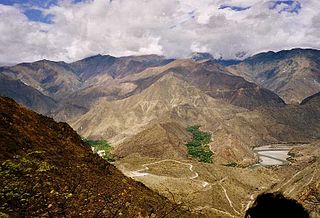
The Huancabamba Depression is an east-west depression through the Andes Mountains of northern Peru. The Huancabamba Depression interrupts the Central and Eastern Cordilleras of the Andes, and the Marañón River and its tributaries drain eastward through the depression into the Amazon basin. Western Cordillera has its lowest point, 2145 meters, at the Paso de Porculla.

Peru republic in South America

Peru, officially the Republic of Peru, is a country in western South America. It is bordered in the north by Ecuador and Colombia, in the east by Brazil, in the southeast by Bolivia, in the south by Chile, and in the west by the Pacific Ocean. Peru is a megadiverse country with habitats ranging from the arid plains of the Pacific coastal region in the west to the peaks of the Andes mountains vertically extending from the north to the southeast of the country to the tropical Amazon Basin rainforest in the east with the Amazon river.

Marañón River river in Peru and Ecuador

The Marañón River is the principal or mainstem source of the Amazon River, arising about 160 km to the northeast of Lima, Peru, and flowing through a deeply eroded Andean valley in a northwesterly direction, along the eastern base of the Cordillera of the Andes, as far as 5° 36′ southern latitude; from where it makes a great bend to the northeast, and cuts through the jungle Andes, until at the Pongo de Manseriche it flows into the flat Amazon basin. Although historically, the term "Marañon River" often was applied to the river all the way to the Atlantic Ocean, nowadays the Marañon River is generally thought to end at the confluence with the Ucayali River, after which most cartographers label the ensuing waterway the Amazon River.

Amazon basin drainage basin in South America drained via the Amazon River into the Atlantic Ocean

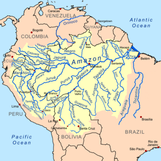
The Amazon Basin is the part of South America drained by the Amazon River and its tributaries. The Amazon drainage basin covers an area of about 6,300,000 km2 (2,400,000 sq mi), or about 35.5 percent that of the South American continent. It is located in the countries of Bolivia, Brazil, Colombia, Ecuador, Guyana, Peru, Suriname and Venezuela.

The Huancabamba Depression is home to the Marañón dry forests, which form both a biogeographic connection between the lowland forests of the Pacific coast and the Amazon basin, and a biogeographic barrier between the Northern Andes and the Central Andes. [1]

Marañón dry forests

The Marañón dry forests (NT0223) is an ecoregion in northern Peru. It covers the lower valley of the Marañón River and its tributaries along the eastern edge of the Andes. It has a dry climate due to rain shadow from mountains further east. The habitat has long been modified by farming, ranching and logging and is now threatened by construction of hydroelectric and irrigation dams.

Biogeography The study of the distribution of species and ecosystems in geographic space and through geological time

Biogeography is the study of the distribution of species and ecosystems in geographic space and through geological time. Organisms and biological communities often vary in a regular fashion along geographic gradients of latitude, elevation, isolation and habitat area. Phytogeography is the branch of biogeography that studies the distribution of plants. Zoogeography is the branch that studies distribution of animals.

Related Research Articles

Amazon River longest river in South America

The Amazon River in South America is the largest river by discharge volume of water in the world, and by some definitions it is the longest.

Geography of Ecuador

Ecuador is a country in western South America, bordering the Pacific Ocean at the Equator, for which the country is named. Ecuador encompasses a wide range of natural formations and climates, from the desert-like southern coast to the snowcapped peaks of the Andes mountain range to the plains of the Amazon Basin. Cotopaxi in Ecuador is one of the world's highest active volcanos. It also has a large series of rivers that follow the southern border and spill into the northwest area of Peru.

Geography of Peru

Peru is a country on the central western coast of South America facing the Pacific Ocean. It lies wholly in the Southern Hemisphere, its northernmost extreme reaching to 1.8 minutes of latitude or about 3.3 kilometres (2.1 mi) south of the equator. Peru shares land borders with Ecuador, Colombia, Brazil, Bolivia and Chile, with its longest land border shared with Brazil.

Geography of Bolivia

The geography of Bolivia includes the Eastern Andes Mountain Range which bisects Bolivia roughly from north to south. To the east of that mountain chain are lowland plains of the Amazon Basin, and to the west is the Altiplano which is a highland plateau where Lake Titicaca is located. Bolivia's geography has features similar to those of Peru which abuts Bolivia's northwest border; like Bolivia, Peru is bisected from north to south by the Eastern Andes Mountains, and these two countries share Lake Titicaca which is the highest navigable lake on Earth. Unlike Peru, however, Bolivia is one of the two landlocked countries in South America, the other being Paraguay which is located along Bolivia's southeast border.

Chuquisaca Department Place in Bolivia

Chuquisaca is a department of Bolivia located in the center south. It borders on the departments of Cochabamba, Tarija, Potosí, and Santa Cruz. The departmental capital is Sucre, which is also the constitutional capital of Bolivia.

Department of Piura Region in 8 provinces and 64 districts, Peru

Piura is a coastal region in northwestern Peru. The region's capital is Piura and its largest port cities, Paita and Talara, are also among the most important in Peru. The area is known for its tropical and dry beaches.

Huallaga River river in Peru

The Huallaga River is a tributary of the Marañón River, part of the Amazon Basin. Old names for this river include Guallaga and Rio de los Motilones. The Huallaga is born on the slopes of the Andes in central Peru and joins the Marañón before the latter reaches the Ucayali River to form the Amazon. Its main affluents are the Monzón, Mayo, Biabo, Abiseo and Tocache rivers. Coca is grown in most of those valleys, which are also exposed to periodic floods.

The Chinchipe River is a river on the border between Ecuador and Peru. It rises in Ecuador, in the Zamora-Chinchipe Province, in the Podocarpus National Park. Then it flows through the Piura Region, and the Cajamarca Region in the San Ignacio Province of Peru. The river flows into the Maranon River.

Manuel Antonio Mesones Muro Peruvian explorer

Manuel Antonio Mesones Muro was born in Ferreñafe in the Lambayeque Region of Peru. He was one of the pioneers of the exploration of north-eastern Peru and a scientist of many talents - a natural historian, geographer, historian, geologist, archeologist and linguist.

Violaceous jay species of bird

The violaceous jay is a species of bird in the family Corvidae, the crows and their allies.

Northern slaty antshrike species of bird

The northern slaty antshrike is a species of bird in the family Thamnophilidae. It previously included the Natterer's slaty antshrike, Bolivian slaty antshrike, Planalto slaty antshrike and Sooretama slaty antshrike as subspecies, in which case the combined species simply was referred to as the slaty antshrike.

The Andean orogeny is an ongoing process of orogeny that began in the Early Jurassic and is responsible for the rise of the Andes mountains. The orogeny is driven by a reactivation of a long-lived subduction system along the western margin of South America. On a continental scale the Cretaceous and Oligocene were periods of re-arrangements in the orogeny. Locally the details of the nature of the orogeny varies depending on the segment and the geological period considered.

The Abra de Porculla, also known as the Paso de Porculla is an east-west pass through the Western Cordillera of the Andes Mountains in northern Peru. At 2145 m above sea level it is the lowest pass through the Andes throughout the entire length of the mountain chain from Colombia to Chile and lies at the point where the Huancabamba Depression also interrupts the Central and Eastern Cordilleras.

Santa Ana is an important archaeological site in the highlands of Ecuador, going back as early as 3,500 BC. It is located in the Palanda Canton, just to the north of its regional capital of es:Palanda, in the Zamora-Chinchipe Province of Ecuador.

Cordillera Central páramo

The Cordillera Central páramo (NT1004) is an ecoregion containing páramo vegetation above the treeline in the Andes mountain range of northern Peru and southern Ecuador. Due to its isolation there are high levels of endemism. Despite many human settlements and some destruction of habitat by agriculture and mining, the ecoregion is relatively intact.

Napo moist forests

The Napo moist forests (NT0142) is an ecoregion in the western Amazon rainforest of Colombia, Ecuador and Peru.

Ucayali moist forests

The Ucayali moist forests (NT0174) is an ecoregion in the western Amazon rainforest of Peru.

Eastern Cordillera Real montane forests

The Eastern Cordillera Real montane forests (NT0121) is an ecoregion in the eastern range of the Andes of southern Colombia, Ecuador and northern Peru. The ecoregion covers the eastern slopes of the Andes, and includes montane forest that rises from the Amazonian rain forest, with cloud forest and elfin forest at higher elevations. It is rich in species, including many endemics. It is threatened by logging and conversion for pasturage and subsistence agriculture.

References

  1. Observations on the biogeography of the Amotape-Huancabamba Zone in northern Peru, Maximilian Weigend, The Botanical Review, 1 Jan 2002

Coordinates: 5°50′00″S79°30′00″W / 5.8333°S 79.5000°W / -5.8333; -79.5000

Geographic coordinate system Coordinate system

A geographic coordinate system is a coordinate system that enables every location on Earth to be specified by a set of numbers, letters or symbols. The coordinates are often chosen such that one of the numbers represents a vertical position and two or three of the numbers represent a horizontal position; alternatively, a geographic position may be expressed in a combined three-dimensional Cartesian vector. A common choice of coordinates is latitude, longitude and elevation. To specify a location on a plane requires a map projection.