Huapalcalco

Last updated
Huapalcalco (Pyramid) Archaeological Site, established during Toltec Period (100-650 CE) Huapalcalco Archaelogical Site.jpg
Huapalcalco (Pyramid) Archaeological Site, established during Toltec Period (100-650 CE)
Olmec (Xicalanca) Culture – Archaeological Site
Huapalcalco Pyramid Tulancingo1.jpg
Huapalcalco Pyramid
Name: Huapalcalco Archaeological Site
TypeMesoamerican archaeology
LocationHuapalcalco, Tulancingo, Hidalgo
Flag of Mexico.svg  Mexico
Region Mesoamerica
Coordinates 20°07′01″N98°21′45″W / 20.11702°N 98.3624°W / 20.11702; -98.3624
CultureOlmeca-Xicalanca – Toltec
Language
Chronology100 – 650 CE
PeriodMesoamerican Preclassical, Classical, Postclassical
Apogee
INAH Web Page

Huapalcalco is a pre-Columbian Mesoamerican archeological site located some 5 kilometers north of Tulancingo in the state of Hidalgo, Mexico. [1]

Contents

The site was built on the west slope of the "Tecolote" hill; the slope is separated east-west by a ravine that forms two sectors at the foot of the hill and two more on the top, all of which contain archaeological vestiges. [1]

The site depicts Teotihuacán influence, and some believe that Topilitzin Quetzalcóatl [2] resided here, before governing Tula. Also it is considered the oldest human occupation site in the state of Hidalgo. [3]

It is believed that it must have been a very important civil, religious and housing center. It is known that it was the second Toltec Empire, before Tula. [3]

The city was of olmeca-xicalanca origin, or the first settler tribes of the great central plateau of the mountain range. The meaning of such wooden building is not known, it was probably built when the ancient native people settled; perhaps it was a building destined as a Telpochcalli, for military training, justice administration, or learning dances or music. [4]

Men passed through the Bering Straits 40 thousand years, 30 thousand years ago, men reached the Mexican plains and about 13 thousand years ago, men reached Huapalcalco in Hidalgo, where vestiges have been located that date back to that period. [3]

Huapalcalco is a mesoamerican classical period (100 to 650 CE), formed part of the State of Teotihuacan; however, both its architecture and pottery is not equal to Teotihuacan, i.e. there is Teotihuacan influence, but are not Teotihuacan. It is not known what culture built these monuments; it can only be said that it is closely related to the Teotihuacan culture and had influence of the cultures of the Gulf Coast. [1]

Background

During the Lithic period (10,000 - 3500 BCE) the first signs of human hunter-gatherers are noted in the valley. It's not until the gradual transition into the archaic period (8000 – 2000 BCE) that we start to see the first human settlements developing in Mesoamerica along with the development of agriculture. The Pre-classical, or Formative Stage, sees the emergence of the first civilization, the Olmecs lasting between (2000 BCE - 250 CE). During the Classical period (250-900 CE) Tulancingo becomes an important trade center, with roads and residential areas. It is during this period that Huapalcalco was built, of which today remain only a three-sided pyramid and stairway, built in the Toltec style.

Cave Paintings. Pinturas rupestres en Huapalcalco.jpg
Cave Paintings.

Cave Paintings

The earliest cave paintings in the area are located at the Huiztle hill and Huapalcalco plateau; these cave paintings transmit testimony of primitive groups’ life experiences in representations of men, schematic outlines, and astronomical figures dating back to 9,000 BCE. [5]

A lizard and men are portrayed. A man is depicted in the act of throwing a prehistoric version of the atlátl spear, a javelin-like weapon used with an arm extension, with a type of large spoon dart in the end, it was used mainly to hunt ducks that must have existed by the thousands in the lagoon located west of the site. [5]

These were hunter-gatherer men that did not have animals in captivity but knew how to hunt and use fire to cook. [5]

Huapalcalco Legend

The Huapalcalco (or Coapalcallico) City was punished by the Gods, the punishment was imposed because their people were not able to defend it against invaders and were conquered by other civilizations, they constructed buildings over their structures. [6]

The Gods were angry by such a situation, hence they completely buried the city, a city that was very expansive, covering an area about 10 km2, which would include the area of what today is from Huapalcalco up to Abra, Santiago and Acatlán. [6]

There was only one solution to remove the curse, the Gods said to the Shamans, the curse could only be removed on June 24 at midnight, at such exact time a bridge would appear between both Coapalcallico hills, over the Main Pyramid. [6]

And only at that instant, a man, woman, boy or girl with the purest and bravest soul could cross it and pull on a gold chain that would appear in the other side of the bridge and after pulling on the chain, the city, buried by the curse of the Gods would reappear. [6]

Tulancingo City-State

An "Aztec" ritual-reenactment is being performed on the Huapalcalco Pyramid. Ritual.jpg
An "Aztec" ritual-reenactment is being performed on the Huapalcalco Pyramid.

Tulancingo, was a forerunner of the Teotihuacan civilization. The name derives from the Nahuatl words "tule" and "tzintle" which mean "in or behind the reeds." This is confirmed by its Aztec glyph. [7]

The area is home to some of the oldest settlements in Mesoamerica, such as Huapalcalco and El Pedregal. These first settlements have been attributed to the Olmecs, Xicalancas and other tribes. The city was founded in 645 BCE by the Toltecs with the name Tolancingo as part of the empire centered in Tula. During this period, the city was home to schools and temples. A calendar stone was sculpted here and a temple called Mitlancalco was built to receive the bodies of priests and princes. After 1116 CE, the Toltec empire declined and the city was abandoned. [7]

According to the Tribute Codex (Códice de los Tributos), the Tulancingo area was a commercial center for the Otomi-Tepehua and Totonac people since about 1000 CE bringing traders from lands now in the states of Hidalgo, Puebla and Veracruz. Traditional trading still exists in the form of the Thursday "Tianguis" or market. [8]

The Chichimecas came to rule here under King Xolotl (Chichimec ruler) starting around 1120. The city was refounded by these people and the remaining Toltecs. The population increased with the arrival of the Tlaxcaltecas. In 1324, a king named Quinantzin, reorganized the area politically, making Tulancingo the head of a province. Tulancingo marched against Texcoco, but was defeated. In the early 15th century, this same Texcoco, under Huitzilihuit, conquered Tulancingo, putting it within the Aztec Empire. In 1431, the Tulancingo area was again reorganized politically under Itzcoatl and Nezahualcoyotl. [7]

Eventually, Tulancingo became part of the Texcoco empire and in 1416, was taken by the Aztec might empire. Since then, Tulancingo was divided into two sectors: Tlaixpa, located to the east, inhabited mostly by native Otomi; and Tlatoca in the west, inhabited by Nahua. The inhabitants of both sides paid tribute to the Aztec kingdom; tributes consisted of cotton blankets and seeds, such as corn and amaranth.

Although Tulancingo was a tributary of the Mexicas, they maintained certain administrative independence, they choose their own authorities. This city was an important food stocking place for the Aztecs.

Olmec-Xicalanca

The mid-classical period ended in Northern Mesoamerica with the decline of Teotihuacan ca 700 CE. This allowed regional centers of power to flourish and compete for control of trade routes and the exploitation of natural resources. In this way the late Classic era commenced. As stated above, this was a time of political fragmentation during which no city had complete hegemony. Various population movements occurred during this period, caused by the incursion of groups from Aridoamerica and other northern regions, who pushed the older populations of Mesoamerica toward the south. Among these new groups were the Nahua, who would found the cities of Tula and Tenochtitlan, the two most important capitals of the Postclassical era. In addition to the migrations from the north, southern peoples finally established themselves in the center of Mexico. Among these were the Olmec-Xicalanca, who came from the Yucatán Peninsula and founded Cacaxtla and Xochicalco.

The term Olmec-Xicalancas refers to a particular culture (not to be confused with the pre-classical Olmec civilization), whom occupied and influenced the nearby areas. A unique difference between the Olmec-Xicalancas groups [and other Mesoamerican cities] were that each group (city-state) would have been governed by a tahualz, a King or ruler, independent of each other. In reality, they had two tahualz for each city-state.[ citation needed ]

They had a writing system that at least included 10 signs, pictograms of the Sun, the Moon, a tree, a field harvest, a person, etc. Religion would have been polytheistic. The most important was the Sun God called different in both villages.

Other Olmec-Xicalanca Sites:

The Site

Huapalcalco Pyramid - Archaeologists say it was influenced by, but not designed by the contemporary builders of Teotihuacan Valley of the Sun pyramids - fifty miles away. Huapalcalco (Pyramid) Archaeological Site.jpg
Huapalcalco Pyramid - Archaeologists say it was influenced by, but not designed by the contemporary builders of Teotihuacan Valley of the Sun pyramids - fifty miles away.

Huapalcalco corresponds to the Mesoamerican Classical period (100 to 650 CE) and was part of the state of Teotihuacán, nevertheless, both their architecture and ceramics are not the same as to those used in Teotihuacán culture, that is to say, they have Teotihuacán influence but are not of Teotihuacan origin. It is not known who constructed these monuments, it can only be said that it has a large Teotihuacan cultural influence and it had influence on other Gulf Coast cultures. [1]

Investigations

The northwestern sector, perhaps the most important, was explored in 1954 by archaeologist Florencia Jacobs Müller and Cesar Lizardi Ramos. After nine expeditions, concluding in 1959, they discovered a pyramidal monument complex with evident Teotihuacán influence and a plaza with a Stele (Mayan influence), Totonac yokes and a round altar. [1]

The remarkable finding of Totonac yokes shows the influence of the Gulf of Mexico coastal cultures, as well as the discovery of a sculpture of the Teotihuacan God of fire. [1]

An important finding was achieved when excavating the deepest part of one of the buildings, it consisted of arrowheads meserve type, that correspond to a pre-ceramic culture 7,000 BCE., and whose chronology matches a hand axe found of prehistoric type in the remains of a burnt cave in cliffs of "el Tecolote" hill, where also were found cave paintings of geometric human character predominating the red color, demonstrating the presence of Paleolithic man (approximately 10,000 BCE) in Huapalcalco. [1]

A recent finding on the highest part of "El Tecolote" hill, located at the south-eastern corner, consisting of a pyramid foundation built with stone slabs and stucco finishing. A symmetrical monument, not yet explored, is located at the north-east corner, at the other side of the ravine, natives know the place as "iglesias viejas". [1]

Huapalcalco has a 39 hectares extension, where more than 55 families currently live; within this area is the Archaeological Site in an enclosed 4 hectares perimeter. [3]

Topographic map of Huapalcalco. Mapa topografico de huapalcalco.JPG
Topographic map of Huapalcalco.

Toponymy

Huapalcalco is a Nahuatl word, huapalli, "board or small beam "; calli, "house", y co, location proposition. Means "place of the wooden house ". [1]

The Huapalcalco Glyph represents a battlement building, with three doors, apparently made from wood, different from the common calli glyph, is the graphical idea of huapalcalli [vapalcalli], which means "tent or house of tables." Huapal calli, is composed of calli, house, and huapalli or huapalitl, board or small beam: Huapal cal co, "in the house of boards, "or the wooden building". [4]

Structures

The site features a Teotihuacan influenced three-sided pyramid, 12 meters base by 8 meters high, with an altar that possibly was used for sacrificial offerings. [3]

There are approximately 28 knolls: small pyramids buried, in which no archaeological work has been made.

The hill slope is divided by a ravine that divides the two sectors, this place is where Friar Bernardino de Sahagún passed and described it saying that it "has crystalline water cascades, at the foot stones, women were washing clothes while children swam and plunged into water". [3]

Over the ravine stones are the cave paintings, which are difficult to see, these are dispersed over the "Cerro La Mesa" behind the pyramid. It is sad that graffiti has reached them, making them in some points confusing. Also white crosses are painted in the stone by current inhabitants of the place, namely to scare away witches and nahuales. [3]

On the slope, between rocky crags, the walls sink shaping the well-known caves of the place; villagers usually place altars to honor their dead. In front of the "Tecolote" Cave, the remains of a prehistoric man was found, according to carbon 14 tests made, this man lived here 10 thousand years ago. The remains are kept in the National Museum of Anthropology and History of Mexico City, in the Prehistoric Room. [3]

Vandalism

Vandals destroyed the Huapalcalco archaeological zone, considered one of Tulancingo cultural patrimonies. [9]

Source of construction materials

Stones originating from the pre-Hispanic ruins of the Huapalcalco archaeological zone, in the municipality of Tulancingo, have been used for the construction of houses by people living around the site. This happened due to the evident negligence on the part of the National Institute of Anthropology and History (INAH) state delegation. [10]

Claims of neglect

The archaeological site appeared to be forgotten and neglected without regular maintenance. [11] This contributed to signs of vandalism in the area, putting the Huapalcalco cave paintings (more than 10 thousand years old) in danger from graffiti, bonfire soot, acts of vandalism and employee neglect. [11]

Arriving to the site was difficult. On a side of the federal highway to Tuxpan, that crosses the city of Tulancingo, there is a deviation to Huapalcalco, where a rusty signboard welcomes people to the archaeological zone and cave paintings. The National Institute of Anthropology and History (INAH) logo was barely visible. [11]

As of a visit in January, 2014, the road to the site is marked visibly with blue INAH signs and there are staff onsite to assist visitors.

Related Research Articles

<span class="mw-page-title-main">Toltec</span> Pre-columbian civilization in Tula, Hidalgo, Mexico

The Toltec culture was a pre-Columbian Mesoamerican culture that ruled a state centered in Tula, Hidalgo, Mexico, during the Epiclassic and the early Post-Classic period of Mesoamerican chronology, reaching prominence from 950 to 1150 CE. The later Aztec culture considered the Toltec to be their intellectual and cultural predecessors and described Toltec culture emanating from Tōllān as the epitome of civilization. In the Nahuatl language the word Tōltēkatl (singular) or Tōltēkah (plural) came to take on the meaning "artisan". The Aztec oral and pictographic tradition also described the history of the Toltec Empire, giving lists of rulers and their exploits.

<span class="mw-page-title-main">Teotihuacan</span> Ancient Mesoamerican city

<span class="mw-page-title-main">Pre-Columbian era</span> The Americas prior to European influences

In the history of the Americas, the pre-Columbian era spans from the original settlement of North and South America in the Upper Paleolithic period through European colonization, which began with Christopher Columbus's voyage of 1492. Usually, the era covers the history of Indigenous cultures until significant influence by Europeans. This may have occurred decades or even centuries after Columbus for certain cultures.

<span class="mw-page-title-main">Xochicalco</span> UNESCO World Heritage Site

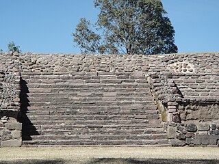
Xochicalco is a pre-Columbian archaeological site in Miacatlán in the western part of the Mexican state of Morelos. The name Xochicalco may be translated from Nahuatl as "in the house of Flowers". The site is located 38 km southwest of Cuernavaca, about 122 km by road from Mexico City. The site is open to visitors all week, from 10 am to 5 pm, although access to the observatory is only allowed after noon. The apogee of Xochicalco came after the fall of Teotihuacan and it has been speculated that Xochicalco may have played a part in the fall of the Teotihuacan empire.

<span class="mw-page-title-main">Mesoamerican chronology</span> Divides the history of pre-Columbian Mesoamerica into several periods

Mesoamerican chronology divides the history of prehispanic Mesoamerica into several periods: the Paleo-Indian ; the Archaic, the Preclassic or Formative (2500 BCE – 250 CE), the Classic (250–900 CE), and the Postclassic (900–1521 CE); as well as the post European contact Colonial Period (1521–1821), and Postcolonial, or the period after independence from Spain (1821–present).

<span class="mw-page-title-main">Mesoamerican languages</span> Languages indigenous to Mesoamerica

Mesoamerican languages are the languages indigenous to the Mesoamerican cultural area, which covers southern Mexico, all of Guatemala and Belize and parts of Honduras and El Salvador and Nicaragua. The area is characterized by extensive linguistic diversity containing several hundred different languages and seven major language families. Mesoamerica is also an area of high linguistic diffusion in that long-term interaction among speakers of different languages through several millennia has resulted in the convergence of certain linguistic traits across disparate language families. The Mesoamerican sprachbund is commonly referred to as the Mesoamerican Linguistic Area.

<span class="mw-page-title-main">Mesoamerican pyramids</span> Prominent architectural features of ancient Mesoamerican civilizations

Mesoamerican pyramids form a prominent part of ancient Mesoamerican architecture. Although similar in some ways to Egyptian pyramids, these New World structures have flat tops and stairs ascending their faces. The largest pyramid in the world by volume is the Great Pyramid of Cholula, in the east-central Mexican state of Puebla. The builders of certain classic Mesoamerican pyramids have decorated them copiously with stories about the Hero Twins, the feathered serpent Quetzalcoatl, Mesoamerican creation myths, ritualistic sacrifice, etc. written in the form of Maya script on the rises of the steps of the pyramids, on the walls, and on the sculptures contained within.

<span class="mw-page-title-main">Cuicuilco</span>

Cuicuilco is an important archaeological site located on the southern shore of Lake Texcoco in the southeastern Valley of Mexico, in what is today the borough of Tlalpan in Mexico City.

<span class="mw-page-title-main">Mesoamerica</span> Pre-Columbian cultural area in the Americas

Mesoamerica is a historical region and cultural area that begins in the southern part of North America and extends to most of Central America, thus comprising the lands of central Mexico, Belize, and Guatemala, El Salvador, and Honduras. In the pre-Columbian era, many societies flourished in Mesoamerica for more than 3,000 years before the Spanish colonization of the Americas begun at Hispaniola island in 1493. In world history, Mesoamerica was the site of two historical transformations: (i) primary urban generation, and (ii) the formation of New World cultures from the mixtures of the indigenous Mesoamerican peoples with the European, African, and Asian peoples who were introduced by the Spanish colonization of the Americas.

<span class="mw-page-title-main">Cholula (Mesoamerican site)</span> Important city of pre-Columbian Mesoamerica

Cholula was an important city of pre-Columbian Mesoamerica, dating back to at least the 2nd century BCE, with settlement as a village going back at least some thousand years earlier. The site of Cholula is just west of the modern city of Puebla and served as a trading outpost. Its immense pyramid is the largest such structure in the Americas, and the largest pyramid structure by volume in the world.

<span class="mw-page-title-main">Tulancingo</span> Municipality and city in Hidalgo, Mexico

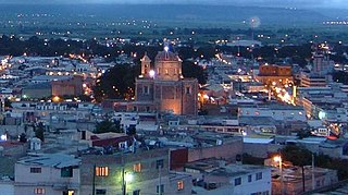
Tulancingo is the second-largest city in the Mexican state of Hidalgo. It is located in the southeastern part of the state and also forms one of the 84 municipalities of Hidalgo, as well as the Archdiocese of Tulancingo. Located 93 km from Mexico City, this area is the most important wool textile producer in the country and was home to El Santo, Mexico's most famous lucha libre wrestler, and to Gabriel Vargas (cartoonist), author of the popular cartoon La Familia Burrón. It is also home to the Huapalcalco archeological site, which was the forerunner to the Teotihuacan civilization. The name derives from the Nahuatl words “tule” and “tzintle” which mean “in or behind the reeds.” This is confirmed by its Aztec glyph.

<span class="mw-page-title-main">Feathered Serpent</span> Mesoamerican concept

The Feathered Serpent is a prominent supernatural entity or deity, found in many Mesoamerican religions. It is still called Quetzalcoatl among the Aztecs, Kukulkan among the Yucatec Maya, and Q'uq'umatz and Tohil among the K'iche' Maya.

<span class="mw-page-title-main">Pre-Columbian Mexico</span> Mexico before Spanish colonization

The pre-Columbian history of the territory now making up the country of Mexico is known through the work of archaeologists and epigraphers, and through the accounts of Spanish conquistadores, settlers and clergymen as well as the indigenous chroniclers of the immediate post-conquest period.

<span class="mw-page-title-main">Painting in the Americas before European colonization</span>

Painting in the Americas before European colonization is the Precolumbian painting traditions of the Americas. Painting was a relatively widespread, popular and diverse means of communication and expression for both religious and utilitarian purpose throughout the regions of the Western Hemisphere. During the period before and after European exploration and settlement of the Americas; including North America, Central America, South America and the islands of the Caribbean, the Bahamas, the West Indies, the Antilles, the Lesser Antilles and other island groups, indigenous native cultures produced a wide variety of visual arts, including painting on textiles, hides, rock and cave surfaces, bodies especially faces, ceramics, architectural features including interior murals, wood panels, and other available surfaces. Many of the perishable surfaces, such as woven textiles, typically have not been preserved, but Precolumbian painting on ceramics, walls, and rocks have survived more frequently.

<span class="mw-page-title-main">Castillo de Teayo (Mesoamerican site)</span> Archaeological site

Castillo de Teayo is a mesoamerican Prehispanic archeological site and Mesoamerican pyramid, located in the La Huasteca region in northern Veracruz, Mexico. The main access to the site is via Federal Highway 130 México-Tuxpan up to the city of Teayo, it belongs to the Huastec culture and it is estimated it was inhabited between the 10th and 12th centuries.

<span class="mw-page-title-main">Chupícuaro</span>

Chupícuaro is an important prehispanic archeological site from the late preclassical or formative period. The culture that takes its name from the site dates to 400 BC to 200 AD, or alternatively 500 BC to 300 AD., although some academics suggest an origin as early as 800 BC.

<span class="mw-page-title-main">El Conde</span> Archeological site in Naucalpan, Mexico

El Conde is an archeological site located at Ozumba Street, El Conde, three block north the Mayo 1 Ave., in the municipality of Naucalpan, Mexico State.

<span class="mw-page-title-main">San Miguel Ixtapan (archaeological site)</span> Archaeological site in Tejupilco, Mexico

San Miguel Ixtapan is an archaeological site located in the municipality of Tejupilco, in the State of Mexico.

Mesa de Cacahuatenco is a Mesoamerican pre-Columbian archeological site, located in the municipality of Ixhuatlán de Madero in northern Veracruz, Mexico, south of the Vinasca River.

<span class="mw-page-title-main">Tula (Mesoamerican site)</span>

References

  1. 1 2 3 4 5 6 7 8 9 "Zona arqueológica de Huapalcalco" [Huapalcalco Archaeological Site]. INAH (in Spanish). Mexico. Archived from the original on 2010-05-07. Retrieved 9 December 2010.
  2. "Huapalcalco, Mexico" [Huapalcalco, Mexico]. Visiting Mexico (in Spanish). Archived from the original on 2010-09-07. Retrieved 9 December 2010.
  3. 1 2 3 4 5 6 7 8 "Vista a Huapalcalco". Tulancingo Cultural (in Spanish). Retrieved 9 December 2010.
  4. 1 2 "Glifo". Tulancingo Cultural.com.mx (in Spanish). Retrieved 9 December 2010.
  5. 1 2 3 "Las pinturas rupestres de Huapalcalco" [The cave paintings of Huapalcalco] (in Spanish). Tulancingo Cultural. Retrieved 9 December 2010.
  6. 1 2 3 4 "Leyenda de Huapalcalco" [Huapalcalco Legend] (in Spanish). Tulancingo.com.mx. Retrieved 9 December 2010.
  7. 1 2 3 "Estado de Hidalgo Tulancingo de Bravo" [State of Hidalgo Tulancingo de Bravo]. Enciclopedia de los Municipios de México (in Spanish). Mexico: Instituto Nacional para el Federalismo y el Desarrollo Municipal. 2005. Archived from the original on June 17, 2011. Retrieved July 26, 2010.
  8. "Tianguis Tradicional" [Traditional Outdoor Market] (in Spanish). Tulancingo: Government of Tulancingo. September 9, 2009. Retrieved July 26, 2010.
  9. "Huapalcalco, patrimonio destruido. Sitio arqueológico con grafiti" [Huapalcalco, a much destroyed patrimony. Archaeological Site with graffiti]. Sol de Tulancingo (in Spanish). October 10, 2006. Retrieved 9 December 2010.
  10. Montoya, Ricardo. "Usan piedras de pirámide para construir casas" [Pyramid stones used to build houses]. Milenio Impreso (in Spanish). Archived from the original on 2013-01-28. Retrieved 9 December 2010.
  11. 1 2 3 Gonzalez, Jorge (2009-07-23). "En el olvido, la zona de Huapalcalco" [The Huapalcalco site forgotten]. Milenio Impreso (in Spanish). Archived from the original on 2010-07-27. Retrieved 9 December 2010.

Bibliography

Further reading