
Westphalia is a region of northwestern Germany and one of the three historic parts of the state of North Rhine-Westphalia. It has an area of 20,210 square kilometres (7,800 sq mi) and 7.9 million inhabitants.

North Rhine-Westphalia or North-Rhine/Westphalia, commonly shortened to NRW, is a state (Land) in Western Germany. With more than 18 million inhabitants, it is the most populous state in Germany. Apart from the city-states, it is also the most densely populated state in Germany. Covering an area of 34,084 km2 (13,160 sq mi), it is the fourth-largest German state by size.
The district of Aachen is a district in the west of North Rhine-Westphalia, Germany. Neighboring districts are Heinsberg, Düren, Euskirchen, and also the Netherlands province of Limburg and the Belgian province of Liège. Its administrative body is the Städteregionsparlament, headed by the Städteregionspräsident or "region president".
Düren is a Kreis (district) in the west of North Rhine-Westphalia, Germany. Neighboring districts are Heinsberg, Neuss, Rhein-Erft-Kreis, Euskirchen and Aachen.
The Rhein-Erft-Kreis is a district in the west of North Rhine-Westphalia, Germany. Neighboring districts are Neuss, district-free Cologne, Rhein-Sieg, Euskirchen, Düren.

The Rhein-Sieg-Kreis is a Kreis (district) in the south of North Rhine-Westphalia, Germany. Neighboring districts are Rheinisch-Bergischer Kreis, Oberbergischer Kreis, Altenkirchen, Neuwied, Ahrweiler, Euskirchen, Rhein-Erft-Kreis, the urban district of Cologne. The federal city of Bonn is nearly completely surrounded by the district.

The Siegerland is a region of Germany covering the old district of Siegen and the upper part of the district of Altenkirchen, belonging to the Rhineland-Palatinate adjoining it to the west.
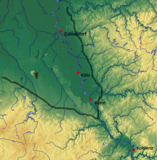
The Cologne Lowland, also called the Cologne Bay or, less commonly, the Cologne Bight, is a densely populated area of Germany lying between the cities of Bonn, Aachen, and Düsseldorf/Neuss. It is situated in the southwest of the state of North Rhine-Westphalia and forms the natural southern conclusion of the Lower Rhenish lowlands and the transition to the Rhenish Massif.
Germany is a country in Central and Western Europe that stretches from the Alps, across the North European Plain to the North Sea and the Baltic Sea. It is the second-most populous country in Europe after Russia, and is seventh-largest country by area in the continent. The area of Germany ranked 63rd and covers 357,600 km2 (138,070 sq mi), consisting of 349,250 km2 (134,846 sq mi) of land and 8,350 km2 (3,224 sq mi) of waters, smaller than Japan but larger than Republic of the Congo.
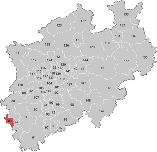
Aachen I is an electoral constituency represented in the Bundestag. It elects one member via first-past-the-post voting. Under the current constituency numbering system, it is designated as constituency 86. It is located in western North Rhine-Westphalia, comprising the city of Aachen.

The Aachen tramway network was the backbone of public transport in Aachen, now in the federal state of North Rhine-Westphalia, Germany, and the surrounding areas from 1880 to 1974. The track gauge was 1,000 mm, see Nordrhein-Westfalen.

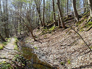
Dichbach is a river of North Rhine-Westphalia, Germany. It is 2.1 km long and a right tributary of the Wahnbach.
Frohnholzbach is a river of North Rhine-Westphalia, Germany.
Hohnderfeldbach is a river of North Rhine-Westphalia, Germany that flows through the Lengsdorf district in Bonn. Since the 1970s, the river sparsely flows on account of holes in the piping as well as a Bundesgrenzschutz hall functioning as a receptacle for water.
Olligsbach is a river of North Rhine-Westphalia, Germany.
Pulheimer Bach is a river of North Rhine-Westphalia, Germany.
Roßsiefenbach is a river of North Rhine-Westphalia, Germany.

Steinbach is a river of North Rhine-Westphalia, Germany, in the district Beuel of Bonn. It flows into the Vilicher Bach, which in this part is called Mühlenbach.
Thelenbach is a river of North Rhine-Westphalia, Germany.
Villiper Bach is a river of North Rhine-Westphalia, Germany.

