The Cotabambas Province is a province located in the Apurímac Region of Peru. The province has a population of 44,028 inhabitants. The capital of this province is the city of Tambobamba.

The Abancay Province is one of seven provinces of the Apurímac Region in Peru. The capital of the province is the city of Abancay.
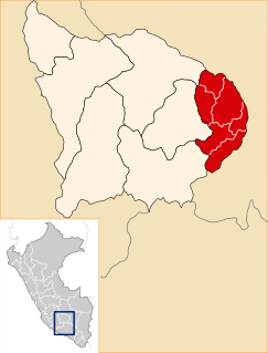
Andahuaylas Province is the second largest of the seven provinces of the Apurímac Region in Peru. The capital of the province is the city of Andahuaylas. The province is located in the north-eastern part of the region and measures 3,987.00 square kilometres (1,539.39 sq mi).

Antabamba Province is one of the seven provinces of the Apurímac Region in Peru. The capital of the province is the city of Antabamba.

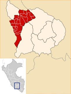
Aymaraes Province is the largest of seven provinces of the Apurímac Region in Peru. The capital of the province is the city of Chalhuanca. The province was founded by General Simón Bolívar on June 21, 1824.
Quriwayrachina, Quri Wayrachina, Hatun Quriwayrachina or Hatun Quri Wayrachina is an archaeological site of the Inca period in Peru located in the Ayacucho Region, Lucanas Province, Carmen Salcedo District. It lies near the mountain Inka Pallanka which is venerated as an apu by the people of the area. There are two platforms which are known as Hatun Quri Wayrachina and Huch'uy Quri Wayrachina by the locals. On April 20, 2011, the site was declared a National Cultural Heritage by Resolución Viceministerial No. 459-2011-VMPCIC-MC.

P'aqu Urqu is a mountain in the Andes of Peru, about 5,000 metres (16,404 ft) high. It is located in the Arequipa Region, Castilla Province, in the south of the Andagua District. P'aqu Urqu lies north-west of Yanawara and north of Huch'uy Yanawara.

Quri Waraqa or Quri Warak'a is a mountain in the Wansu mountain range in the Andes of Peru, about 5,000 metres (16,404 ft) high. It is situated in the Apurímac Region, Antabamba Province, in the districts of Antabamba and Juan Espinoza Medrano. Quri Waraqa lies north of Sara Sara, Panti Pata and Huch'uy Sara Sara.
Wallqa Wallqa is a mountain in the Andes of Peru, about 5,200 metres (17,060 ft) high. It is situated in the Apurímac Region, Antabamba Province, Antabamba District. Wallqa Wallqa lies south-west of the mountains Sara Sara and Runtu Quri, near the northern border of the Arequipa Region.
Hatun Qillqa is a mountain in the Wansu mountain range in the Andes of Peru, about 5,000 metres (16,404 ft) high. It is situated in the Apurímac Region, Antabamba Province, Antabamba District. Hatun Qillqa lies southeast of Qillqa, southwest of Sisiwa and Yuraq Urqu and northwest of Wank'ayuq Saywa.
Sara Sara is a 5,195-metre-high (17,044 ft) mountain in the Wansu mountain range in the Andes of Peru. It is situated in the Apurímac Region, Antabamba Province, in the districts of Antabamba and Juan Espinoza Medrano. Sara Sara lies south of Quri Waraqa and Huch'uy Sara Sara.
Urpi Marka is a 5,068-metre-high (16,627 ft) mountain in the Wansu mountain range in the Andes of Peru. It is situated in the Apurímac Region, Antabamba Province, Juan Espinoza Medrano District. Urpi Marka lies west Sara Sara.
Quri Pawkara is a mountain in the Wansu mountain range in the Andes of Peru, about 5,000 metres (16,404 ft) high. It is situated in the Apurímac Region, Antabamba Province, in the districts of Antabamba and Juan Espinoza Medrano. Its three peaks lie in a row from north to south northwest of Quri Waraqa.
Huch'uy Pirwalla is a mountain in the Andes of Peru, about 4,600 metres (15,092 ft) high. It is situated in the Ayacucho Region, Víctor Fajardo Province, Sarhua District, northeast of Hatun Pirwalla.
Huch'uy Anqas is a 5,182-metre-high (17,001 ft) mountain in the Chunta mountain range in the Andes of Peru. It is situated in the Huancavelica Region, Huancavelica Province, Acobambilla District. Huch'uy Anqas lies south of Anqasqucha and east of the lake named Anqasqucha and north of Chiliqucha.
“‘Huch'uy Puka Q'asa’” is a mountain in the Andes of Peru, about 4,400 metres (14,436 ft) high. It is situated in the Ayacucho Region, Cangallo Province, Totos District, northeast of Totos. Huch'uy Puka Q'asa lies south of Chawpi Urqu. The lake north of it is named Llulluchaqucha (Llullucha Ccocha).
Paychi is a mountain in the Wansu mountain range in the Andes of Peru, about 5,000 metres (16,404 ft) high. It is located in the Apurímac Region, Antabamba Province, Antabamba District. Paychi lies north of Phuk'iña and northeast of Runtu Quri and Sara Sara.
Q'urawiri is a mountain in the Andes of Peru, about 5,000 metres (16,404 ft) high. It is located in the Apurímac Region, Abancay Province, Circa District, and in the Grau Province, Chuquibambilla District. Huch'uy Q'urawiri is northwest of it.
Q'urawiri is a mountain in the Andes of Peru, about 4,800 metres (15,748 ft) high. It is located in the Apurímac Region, Abancay Province, Circa District. It lies northwest of Q'urawiri.


