There are several rivers in the world called the Humber River:

Street-legal, road-legal, or road-going, refers to a vehicle such as a car, motorcycle, or light truck that is equipped and licensed for use on public roads, being therefore roadworthy. This will require specific configurations of lighting, signal lights, and safety equipment. Some specialty vehicles that will not be operated on roads, therefore, do not need all the features of a street-legal vehicle; examples are a vehicle used only off-road that is trailered to its off-road operating area, and a racing car that is used only on closed race tracks and therefore does not need all the features of a street-legal vehicle. As well as motor vehicles, the street-legal distinction applies in some jurisdictions to track bicycles that lack street-legal brakes and lights. Street-legality rules can even affect racing helmets, which possess visual fields too narrow for use on an open road without the risk of missing a fast-moving vehicle.
Humber Limited was a British manufacturer of bicycles, motorcycles, and cars incorporated and listed on the stock exchange in 1887. It took the name "Humber & Co Limited" because of the high reputation of the products of one of the constituent businesses that had belonged to Thomas Humber. A financial reconstruction in 1899 transferred its business to Humber Limited.
The Toronto Suburban Railway was a Canadian electric railway operator with local routes in west Toronto, and a radial (interurban) route to Guelph.

Lake Shore Boulevard is a major arterial road running along more than half of the Lake Ontario waterfront in the city of Toronto, Ontario, Canada. Prior to 1998, two segments of Lake Shore Boulevard were designated as part of Highway 2, with the highway following the Gardiner Expressway between these two sections.

The Queensway is a major street in the municipalities of Toronto and Mississauga, Ontario, Canada. It is a western continuation of Queen Street, after it crosses Roncesvalles Avenue and King Street in Toronto. The Queensway is a divided roadway from Roncevalles westerly until 600 metres of the South Kingsway with its centre median dedicated to streetcar service. The road continues undivided west from there to Etobicoke Creek as a four- or six-lane thoroughfare.

The Toronto streetcar system is a network of nine streetcar routes in Toronto, Ontario, Canada, operated by the Toronto Transit Commission (TTC). It is the busiest light-rail system in North America. The network is concentrated primarily in Downtown Toronto and in proximity to the city's waterfront. Much of the streetcar route network dates from the 19th century. Most of Toronto's streetcar routes operate on street trackage shared with vehicular traffic, and streetcars stop on demand at frequent stops like buses.

501 Queen is an east–west Toronto streetcar route in Ontario, Canada, operated by the Toronto Transit Commission (TTC). At 24.6 kilometres (15.3 mi) long, it is one of the longest surface routes operated by the TTC, the longest streetcar route operating in Canada and one of the longest streetcar routes operating in the world. It stretches from Long Branch Loop in the west to Neville Park Loop in the east, running on Lake Shore Boulevard, in a reserved right-of-way within the median of the Queensway, and on Queen Street. This route operates as part of the TTC's Blue Night Network service, operating from approximately 1 am to 5 am as the 301 Queen.

The Canadian Light Rail Vehicle (CLRV) and Articulated Light Rail Vehicle (ALRV) were types of streetcars used by the Toronto Transit Commission (TTC) from the late 1970s until the late 2010s. They were built following the TTC's decision to retain streetcar services in the 1970s, replacing the existing PCC streetcar fleet.
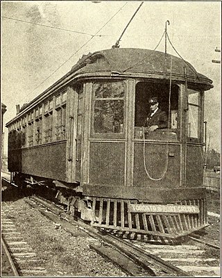
The Toronto and Mimico Electric Railway and Light Company was incorporated in 1890, and operated the Mimico radial line in the Toronto area. The line started operation in 1892 as a short suburban line that later was extended to Port Credit. In 1904, the railway was acquired by the Toronto and York Radial Railway (T&YRR) and became the T&YRR Mimico Division. In 1922, the City of Toronto acquired the T&YRR and contracted Ontario Hydro to manage the four T&YRR lines including the Mimico line. In 1927, the TTC took over the operation of the Mimico line and extended its service eastward to Roncesvalles Avenue. In 1928, the TTC double-tracked the line from Humber to Long Branch and made that portion part of the Lake Shore streetcar line. The portion beyond Long Branch to Port Credit became the Port Credit line, and continued operation as a single-track radial line until its closure on February 9, 1935.

The Lynx reconnaissance vehicle is a United States-built tracked reconnaissance armoured fighting vehicle, which was employed by the armed forces of the Netherlands and Canada. Dutch vehicles were exported in the 1990s to Bahrain and Chile, according to SIPRI 150 and 8 vehicles respectively.

The Queensway–Humber Bay, known officially as Stonegate–Queensway, is a neighbourhood in the southwest of Toronto, Ontario, Canada. It is located in the southeast area of the former City of Etobicoke.
The Waterfront West LRT (WWLRT) is a proposed streetcar line in Toronto, Ontario, Canada. The WWLRT is currently part of a City project called the Waterfront Transit Reset which also includes the East Bayfront LRT. The WWLRT was initially proposed as part of the Transit City plan to expand transit services offered by the Toronto Transit Commission that was announced March 16, 2007. The new line was to use existing parts of the Toronto streetcar system, extending from Union station to Long Branch Loop via Exhibition Place.
Vehicle registration plates of Canada are issued by an agency of the provincial or territorial governments.
Humber Loop is a station and intermediate turning loop for streetcars on the 501 Queen line of the Toronto Transit Commission (TTC). It is located between the Gardiner Expressway and The Queensway just west of the Humber River in Toronto. The loop is accessed by a private right-of-way that connects tracks eastbound to The Queensway and westbound to Lake Shore Boulevard. The 501 streetcar is split here; higher capacity streetcars head east from here to Neville Park Loop, and shorter Canadian Light Rail Vehicle (CLRV) streetcars head west from here to Long Branch Loop.

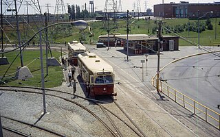
The Roncesvalles Carhouse is a storage and maintenance facility for the streetcar network of the Toronto Transit Commission. Located at the northwest corner of The Queensway and Roncesvalles Avenue in Toronto, Ontario, west of its downtown core, it is the oldest of the TTC's three active carhouses. The carhouse serves vehicles on routes 501 Queen, 504 King, 505 Dundas, 506 Carlton, 511 Bathurst, and 512 St. Clair.

Davenport Road is an east–west arterial road in Toronto, Ontario, Canada. It is believed to follow an old native trail along the foot of the scarp of the old shoreline of glacial Lake Iroquois. It currently runs from Yonge Street in the east to Old Weston Road in the west.

Long Branch Loop is the westernmost stop on the longest Toronto Transit Commission (TTC) streetcar route, the 501 Queen line. It is located in the Long Branch neighbourhood in southwestern Toronto, close to the boundary with Mississauga.
Jane Loop was an important Toronto Transit Commission (TTC) streetcar turning loop and bus station, prior to the completion of the Bloor Danforth Subway line. The Jane Loop opened on December 31, 1923; it was the western end of Bloor Streetcar line from 1925 to 1968. The loop was at a boundary between two zones in the TTC's zoned fare system. Half a dozen or so buses and trolleybuses terminated at the loop.

Toronto-gauge railways are tram and rapid transit lines built to Toronto gauge, a broad gauge of 4 ft 10+7⁄8 in. This is 2+3⁄8 in (60 mm) wider than standard gauge of 4 ft 8+1⁄2 in which is by far the most common track gauge in Canada. The gauge is unique to the Greater Toronto Area and is currently used on the Toronto streetcar system and the Toronto subway, both operated by the Toronto Transit Commission. As well, the Halton County Radial Railway, a transport museum, uses the Toronto gauge so its rail line can accommodate its collection of Toronto streetcars and subway trains. Several now-defunct interurban rail systems also once used this gauge.