
Humboldt County is a county located in the U.S. state of California. As of the 2020 census, the population was 136,463. The county seat is Eureka.

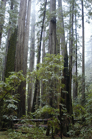
Humboldt Redwoods State Park is a state park of California, United States, containing Rockefeller Forest, the world's largest remaining contiguous old-growth forest of coast redwoods. It is located 30 miles (48 km) south of Eureka, California, near Weott in southern Humboldt County, within Northern California, named after the great German nineteenth-century scientist, Alexander von Humboldt. The park was established by the Save the Redwoods League in 1921 largely from lands purchased from the Pacific Lumber Company. Beginning with the dedication of the Raynal Bolling Memorial Grove, it has grown to become the third-largest park in the California State Park system, now containing 51,651 acres (20,902 ha) through acquisitions and gifts to the state.
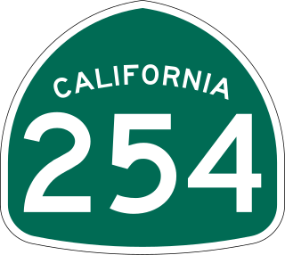
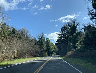
The Avenue of the Giants is a scenic highway in northern California, United States, running through Humboldt Redwoods State Park. It is named after the coastal redwoods that tower over the route. The road is a former alignment of U.S. Route 101, and continues to be maintained as a state highway as State Route 254.

Garberville is a census-designated place in Humboldt County, California. It is located on the South Fork of the Eel River 52 miles (84 km) south-southeast of Eureka, at an elevation of 535 feet (163 m). The population was 913 at the 2010 United States Census. It is approximately 200 miles (320 km) north of San Francisco, California, and within a fifteen-minute drive to Humboldt Redwoods State Park and a sixty-minute drive to Eureka, the county seat. Garberville is the primary town in the area known as the Mateel Region, consisting of parts of the Mattole and Eel River watersheds in southern Humboldt and northern Mendocino counties.

The North Coast of California is a region in Northern California that lies on the Pacific coast between San Francisco Bay and the Oregon border. It commonly includes Mendocino, Humboldt, and Del Norte counties and sometimes includes Lake and two counties from the San Francisco Bay area, Marin and Sonoma.

Whitethorn is an unincorporated community in Humboldt County, California, United States. It is located 9.5 miles southwest of Garberville, at an elevation of 1,024 feet, with a population of 817. Whitethorn shares a ZIP Code, 95589, with Shelter Cove, California. It is located along California's Lost Coast.
Weott is a census-designated place in Humboldt County, California. It is located 233 miles (375 km) north of San Francisco and 25 miles (40 km) due east of the Pacific Ocean. Lower Weott is situated at an elevation of 330 feet (100 m) along the Avenue of the Giants scenic highway and in the flood plain of the South Fork of the Eel River. The population was 288 at the 2010 census.
Pepperwood is an unincorporated community in Humboldt County, California. It is located 3.5 miles (5.6 km) northwest of Redcrest, at an elevation of 115 feet. Pepperwood is the northernmost community along the Avenue of the Giants. The ZIP Code is 95569. The community is inside area code 707.
The Avenue of the Giants Marathon is held annually in May along the Avenue of the Giants in Humboldt Redwoods State Park in Humboldt County, California, United States.
KMUD is a community radio station broadcasting a variety format. Licensed to Garberville, California, the station serves Humboldt, Northern Mendocino, and western Trinity counties in the North Coast region. KMUD is owned by Redwood Community Radio and its studios are located in Redway, California.
Blocksburg is an unincorporated community in Humboldt County, California. It is located 15 miles (24 km) east-southeast of Weott, at an elevation of 1,594 feet (486 m). The ZIP Code is 95514.
Briceland is an unincorporated community in Humboldt County, California. It is 6 miles (10 km) west of Redway, at an elevation of 594 feet.
Bull Creek is a locality 11 miles (18 km) south-southeast of Scotia, at an elevation of 7 feet (2.1 m) in Humboldt County, California. Bull Creek Road parallels Bull Creek and is also known as the Mattole Road.
Englewood is an unincorporated community in Humboldt County, California. It is located 0.5 miles (0.8 km) east-southeast of Redcrest, at an elevation of 364 feet. In 2009, the area was the site of a few homes and a derelict Eel River Sawmills mill.
Korbel is an unincorporated community in Humboldt County, California. It is located 1.5 miles (2.4 km) east-southeast of Blue Lake, at an elevation of 154 feet. The ZIP Code is 95550.
Albeeville is a former settlement in Klamath County, now located in Humboldt County, California. Albeeville was located on Redwood Creek, within an easy day's travel from Fort Gaston. The post office was named for Joseph Porter Albee, its first postmaster, who was murdered by Indians, and the Albeeville post office burned in November 1863.
Fort Anderson or Camp Anderson was a military post first established in May 1862 by California Volunteers during the Bald Hills War. It was located on Redwood Creek, below its confluence with Minor Creek, between Fort Humboldt and Fort Gaston. It was abandoned in the winter of 1862, but reestablished in 1864 and finally closed in 1866.

Dyerville is a former settlement in Humboldt County, California. It was located at an elevation of 246 ft on the northwest bank of the Eel River confluence with the South Fork Eel River 3 miles (4.8 km) west of Camp Grant. Earliest known development at Dyerville was the operation of a ferry in the 1870s. Dyerville had its own post office from April 17, 1890, to November 30, 1933, when it was moved to South Fork.
Sequoia County was a proposal in the early 1990s, to create a new county out of parts of Southern Humboldt and Northern Mendocino counties in California. The 1992 proposal halted signature gathering due to low support. The proponents of the proposal, restarted in 1993, submitted signatures in January 1994 to the Humboldt County clerk, who validated 2,033 signatures, 169 short of the necessary number to qualify for possible inclusion on the 1996 ballot.
Freshwater Creek is a 23 kilometres (14 mi) long creek in Humboldt County, California that is a tributary of the Eureka Slough that in turn feeds Humboldt Bay. It flows into the south-east corner of the Arcata Bay sub-bay of Humboldt Bay. Its downstream reach is also known as Freshwater Slough and its upstream reach as Freshwater Gulch.