
Coonawarra is a small town north of Penola in South Australia.
Rolling Stone Australia was the Australian edition of the United States' Rolling Stone magazine devoted to music, politics, and popular culture, published monthly. The Australian version of Rolling Stone was initially published in 1970 as a supplement in Revolution magazine published by Monash University student Phillip Frazer. It was launched as a fully fledged magazine in 1972 by Frazer and was the longest surviving international edition of Rolling Stone until its last issue appeared in January 2018.

Clinton is a locality in the Australian state of South Australia located on the east coast of Yorke Peninsula overlooking the north west head of Gulf St Vincent about 101 kilometres (63 mi) west of the state capital of Adelaide and about 36 kilometres (22 mi) north-east of the municipal seat of Maitland.

Ucolta is a locality in the Mid North region of South Australia. It is named for a railway station on the Broken Hill-Port Pirie railway line. Trains no longer stop at Ucolta. It is also where the Barrier Highway first meets the railway line, and the Wilmington–Ucolta Road which connects across the northern side of the Mid North, providing the shortest road route from Western Australia and Eyre Peninsula via Port Augusta to Broken Hill and New South Wales.
Kainton is a small town in the Australian state of South Australia situated about 10 km south of Paskeville in the upper Yorke Peninsula.
The District Councils Act 1887 was an act of the Parliament of South Australia. It received assent on 9 December 1887, and its provisions came into effect when proclaimed by Governor William C. F. Robinson on 5 January 1888.
The District Council of Crystal Brook was a local government area in South Australia from 1882 until 1988, seated at Crystal Brook.
The District Council of Burra was a local government area in South Australia from 1872 to 1935.
Clinton Centre is a locality in the Australian state of South Australia located on the northern end of Yorke Peninsula about 99 kilometres north-west of the state capital of Adelaide and about 27 kilometres north-east of the municipal seat in Maitland.
The District Council of Snowtown was a local government area in South Australia from 1888 to 1987.
The District Council of Yorke Peninsula was a local government area on the Yorke Peninsula of South Australia from 1888 to 1969.
The District Council of Port Wakefield was a local government area seated at Port Wakefield in South Australia from 1878 to 1983.
The Hundred of Narridy is a cadastral unit of hundred located in the Mid North of South Australia in the approach to the lower Flinders Ranges.

The Hundred of Moule is a cadastral hundred of South Australia established in 1889 in the remote County of Way. Now bisected by the Eyre Highway, the traditional owners of the area are the Waringu people.

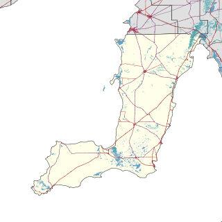
The Hundred of Killanoola is a hundred in the County of Robe in the Limestone Coast region of South Australia.

Dawlish is a former government town whose site is located in the locality of Erskine north of Peterborough, South Australia.
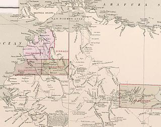
County of Malmesbury was one of the five counties in the Northern Territory which are part of the Lands administrative divisions of Australia.

County of Herbert is a cadastral unit located in the Australian state of South Australia that covers land to the east of the Flinders Ranges about 55 kilometres (34 mi) north-east of the town of Peterborough. It was proclaimed in 1877 and named after a prominent man of the time with either a title or a surname containing the name ‘Herbert’. It has been partially divided in the following sub-units of hundreds – Cavenagh, Coglin, Minburra, Nackara, Paratoo and Waroonee.

County of Kimberley is a cadastral unit located in the Australian state of South Australia that covers land to the east of the Flinders Ranges about 45 kilometres (28 mi) east of the town of Peterborough. It was proclaimed in 1871 and named after John Wodehouse, 1st Earl of Kimberley, a British Secretary of State for the Colonies. It has been partially divided in the following sub-units of hundreds – Gumbowie, Hardy, Ketchowla, Parnaroo, Terowie and Wonna.

County of Hanson is a cadastral unit located in the Australian state of South Australia that covers land in the Flinders Ranges immediately east of the town of Hawker. It was proclaimed on 20 July 1877 and is named after Sir Richard Davies Hanson who served as Premier, Administrator and Chief Justice of South Australia. It has been partially divided in the following sub-units of hundreds – Adams, Arkaba, French, Moralana and Warcowie.


