Huntercombe is an area of Cippenham in Slough in the Englishhistoric county of Buckinghamshire, although it was administered as part of Berkshire between 1974 and 1996. It adjoins Burnham in Buckinghamshire. The district is well-known to residents of Slough and Burnham, but is usually not listed on maps of the area.
Cippenham is a suburb of the unitary authority of Slough. Originally in the county of Buckinghamshire, England it was transferred to Berkshire from Buckinghamshire in 1974. Slough became a unitary authority on 1 April 1998, with the abolition of Berkshire County Council and the 1973–1998 Borough. Close by are the neighbouring towns and villages of Beaconsfield, Farnham Common, Burnham, Gerrards Cross, Stoke Poges, Windsor and Taplow.
Slough is a large town in Berkshire, England, 20 miles (32 km) west of central London and 17 miles (27 km) north-east of Reading, in the Thames Valley at the intersection of the M4, M40 and M25 motorways. Slough had a population of 164,000 in 2017.
England is a country that is part of the United Kingdom. It shares land borders with Wales to the west and Scotland to the north. The Irish Sea lies west of England and the Celtic Sea to the southwest. England is separated from continental Europe by the North Sea to the east and the English Channel to the south. The country covers five-eighths of the island of Great Britain, which lies in the North Atlantic, and includes over 100 smaller islands, such as the Isles of Scilly and the Isle of Wight.
The area includes the public house Huntercombe Arms, situated on the Huntercombe Roundabout. This leads to the Huntercombe Spur, a dual carriageway to J7 on the M4 Motorway. On the Burnham side of the area, it includes the Maidenhead Huntercombe Hospital (formerly Huntercombe Manor), which is part of The Huntercombe Group, and Burnham Abbey.
The M4, a motorway in the United Kingdom running from west London to southwest Wales, was originally referred to as the London-South Wales Motorway. The English section to the Severn Bridge was constructed between 1961 and 1971; the Welsh element was completed in 1993. The Second Severn Crossing officially renamed the Prince of Wales Bridge, was inaugurated on 5 June 1996 by the Prince of Wales and the M4 was rerouted. Apart from its two spurs—the A48(M) and the M48—the M4 is the only motorway in Wales.
The Huntercombe Group is a specialist health provider in the United Kingdom operated by Four Seasons Health Care, it has 56 hospitals and specialist centres located throughout England and Scotland. It specialises in specific areas of health including: eating disorders, mental health and specialist brain injury services.
Burnham Abbey was a house of Augustinian Canonesses Regular near Burnham in Buckinghamshire, England. It was founded by Richard, 1st Earl of Cornwall. The monastery consisted of around twenty nuns at the outset, but was never especially wealthy and by the time of its dissolution in 1539 there were only ten.
A geographic coordinate system is a coordinate system that enables every location on Earth to be specified by a set of numbers, letters or symbols. The coordinates are often chosen such that one of the numbers represents a vertical position and two or three of the numbers represent a horizontal position; alternatively, a geographic position may be expressed in a combined three-dimensional Cartesian vector. A common choice of coordinates is latitude, longitude and elevation. To specify a location on a plane requires a map projection.
Wexham is a civil parish in the county of Buckinghamshire in southern England. It is on the boundary of the unitary authority of Slough, its post town. Wexham Park Hospital is a large hospital on the parish border and Burnham Beeches, a forest takes in small parts of its northern land.
The Thames Valley is an informally-defined sub-region of South East England, centred on the River Thames west of London, with Oxford as a major centre. Its boundaries vary with context. The area is a major tourist destination and economic hub, includes part of the M4 corridor, and is sometimes referred to as England's Silicon Valley due to the concentration of high-technology companies. The area east of Reading is defined by Natural England as the Thames Valley National Character Area, while Thames Valley Police cover the counties of Berkshire, Buckinghamshire and Oxfordshire.
Burnham is a large village and civil parish that lies north of the River Thames in the South Bucks District of Buckinghamshire, between the towns of Maidenhead and Slough, about 23 miles west of Charing Cross, London. It is probably best known for the nearby Burnham Beeches woodland.
George Green is a hamlet in the parish of Wexham, in the South Bucks district of Buckinghamshire, England. It is situated between Slough and Iver Heath, close to the boundary of the borough of Slough.
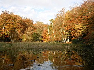
Burnham Beeches is a 374.6 hectare biological Site of Special Scientific Interest situated west of Farnham Common in the village of Burnham, Buckinghamshire. The southern half is owned by the Corporation of London and is open to the public. It is also a National Nature Reserve and a Special Area of Conservation.
Beaconsfield is a constituency represented in the House of Commons of the UK Parliament since 1997 by Dominic Grieve QC of the Conservative Party, the former Attorney General of England and Wales. On 3 September 2019 Grieve had the Conservative Whip removed after rebelling against the Government.
Eton was a rural district in the administrative county of Buckinghamshire, England. It was named after but did not contain Eton, which was an urban district.
Burnham Park E-ACT Academy was a co-educational academy in Burnham, Buckinghamshire, England until it closed in 2019 due to falling pupil numbers. It. A small part of the campus is located in neighbouring Slough, Berkshire. The academy was sponsored by E-ACT, and had approximately 235 pupils.
The A412 is a road in England between Slough and Watford. It was the main artery for this corridor and used to continue to St Albans prior to the construction of the M25. It provides interchange to the A4 in Slough, the A40/M40 at the Denham Roundabout, the M25 in Maple Cross, the A404 in Rickmansworth town centre, the A411 on a partially grade separated dual carriageway in Watford town centre, and the A41 in North Watford.
Middlegreen is a hamlet in the civil parish of Wexham in Buckinghamshire, England. It is located within the Metropolitan Green Belt bordering the north-east edge of Slough and close to the Slough Arm of the Grand Union Canal. Just to the south of the hamlet is the Middlegreen Trading Estate.
Dropmore Park and Dropmore House are located along Dropmore Road, north of Burnham, Buckinghamshire, England, and is about 220 acres (89 ha) in size. The park with its buildings have Grade I listed building status. It is one of the most important buildings in south Bucks.
Burnham Hundred is a hundred in the ceremonial county of Buckinghamshire, England. It is situated towards the south of the county and is bounded on the north by Hertfordshire and on the south by Berkshire.
Slough was, from 1863 to 1974, a local government district in southern Buckinghamshire, England. It became an urban district in 1894 and was incorporated as a municipal borough in 1938. It was abolished in 1974 and now forms part of the borough of Slough in Berkshire.
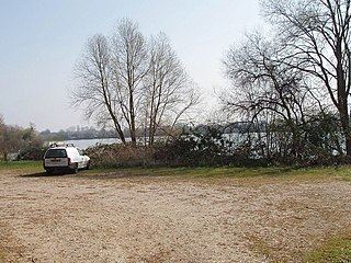
Taplow Lake is a 30-acre (120,000 m2) lake just south of the A4 between Maidenhead and Slough in Amerden Lane, Buckinghamshire. Recreational activities on the lake include swimming, wakeboarding and waterskiing.
Chalvey Road was a cricket ground in Slough, Buckinghamshire. Slough Cricket Club moved to the ground in 1899, with the first recorded match on the ground in 1904, when Buckinghamshire played Berkshire in the Minor Counties Championship. From 1904 to 1998 the ground hosted 57 Minor Counties Championship matches, the last of which saw Buckinghamshire play Norfolk. Buckinghamshire also played a single MCCA Knockout Trophy match held at the ground, against Oxfordshire in 1992. In 1999, Berkshire played an MCCA Knockout Trophy match against the Sussex Cricket Board.
Buttlers Hangings is a 3.9 hectare Site of Special Scientific Interest north of West Wycombe in Buckinghamshire. It is in the Chilterns Area of Outstanding Natural Beauty.
Haymill Valley is a local nature reserve in Berkshire, England, between the village of Burnham in Buckinghamshire, Britwell in Slough and Slough Trading Estate. The site is known locally as The Millie. The nature reserve is owned by Slough Borough Council with a small part owned by the Environment Agency, it is under the management of the Berkshire, Buckinghamshire and Oxfordshire Wildlife Trust.
Cocksherd Wood is a Local nature reserve in Britwell in Slough, Berkshire, England. The reserve is known locally as Bluebell Wood. The nature reserve is owned by Slough Borough Council and managed by the Evergreen 2000 trust.
This page is based on this Wikipedia article Text is available under the CC BY-SA 4.0 license; additional terms may apply. Images, videos and audio are available under their respective licenses.