The Wyandot people are Indigenous peoples of the Northeastern Woodlands of North America, and speakers of an Iroquoian language, Wyandot.
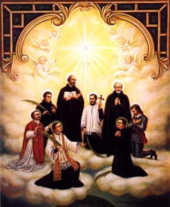
The Canadian Martyrs, also known as the North American Martyrs, were eight Jesuit missionaries from Sainte-Marie among the Hurons. They were ritually tortured and killed on various dates in the mid-17th century in Canada, in what is now southern Ontario, and in upstate New York, during the warfare between the Iroquioan tribes the Mohawk and the Huron. They have subsequently been canonized and venerated as martyrs by the Catholic Church.

Georgian Bay is a large bay of Lake Huron, in the Laurentia bioregion. It is located entirely within the borders of Ontario, Canada. The main body of the bay lies east of the Bruce Peninsula and Manitoulin Island. To its northwest is the North Channel.

Midland is a town located on Georgian Bay in Simcoe County, Ontario, Canada. It is part of the Huronia/Wendat region of Central Ontario.

The Neutral Confederacy was a tribal confederation of Iroquoian peoples. Its heartland was in the floodplain of the Grand River in what is now Ontario, Canada. At its height, its wider territory extended toward the shores of lakes Erie, Huron, and Ontario, as well as the Niagara River in the east. To the northeast were the neighbouring territories of Huronia and the Petun Country, which were inhabited by other Iroquoian confederacies from which the term Neutrals Attawandaron was derived. The five-nation Iroquois Confederacy was across Lake Ontario to the southeast.

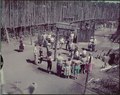
Sainte-Marie among the Hurons was a French Jesuit settlement in Huronia or Wendake, the land of the Wendat, near modern Midland, Ontario, from 1639 to 1649. It was the first European settlement in what is now the province of Ontario. Eight missionaries from Sainte-Marie were martyred, and were canonized by the Catholic Church in 1930. Sainte-Marie Among the Hurons was designated a National Historic Site of Canada in 1920. A reconstruction of the mission now operates as a living museum.

Wendake is the current name for two urban reserves, Wendake 7 and Wendake 7A, of the Huron-Wendat Nation in the Canadian province of Quebec. They are enclaves entirely surrounded by the La Haute-Saint-Charles borough of Quebec City, within the former city of Loretteville. One of the Seven Nations of Canada, the settlement was formerly known as Village-des-Hurons, and also as (Jeune)-Lorette.
The Huron-Wendat Nation is an Iroquoian-speaking nation that was established in the 17th century. In the French language, used by most members of the First Nation, they are known as the Nation Huronne-Wendat. The French gave the nickname “Huron” to the Wendat, meaning “boar's head” because of the hairstyle of Huron men. Wendat (Quendat) was their confederacy name, meaning “people of the island” or "dwellers on a peninsula."

Tiny, also known as Tiny Township, is a township in Simcoe County, south-central Ontario, Canada. The Township of Tiny can be found in the southern Georgian Bay region and is approximately 30 kilometres (19 mi) long or 410 square kilometres (160 sq mi).

Crawford Lake Conservation Area is a conservation area owned and operated by Conservation Halton near the community of Campbellville in Milton, Halton, Ontario, Canada. It is categorized as a regional environmentally sensitive area, an Ontario Area of Natural and Scientific Interest, and part of the Niagara Escarpment world biosphere reserve. The conservation area contains Crawford Lake, a reconstructed Iroquoian village, and several hiking trails.
The St. Lawrence Iroquoians were an Iroquoian Indigenous people who existed from the 14th century to about 1580. They concentrated along the shores of the St. Lawrence River in present-day Quebec and Ontario, Canada, and in the American states of New York and northernmost Vermont. They spoke Laurentian languages, a branch of the Iroquoian family.

The Petun, also known as the Tobacco people or Tionontati, were an indigenous Iroquoian people of the woodlands of eastern North America. Their last known traditional homeland was south of Lake Huron's Georgian Bay, in what is today's Canadian province of Ontario

Allandale Waterfront GO Station was built just south of Allandale Station, a historic train station that occupies a large property on the southern shore of Lake Simcoe in the waterfront area of Barrie, Ontario, Canada. The current station and former station were built on a burial site of the Huron indigenous peoples.

The "Jean-Baptiste Lainé" or Mantle Site in the town of Whitchurch–Stouffville, north-east of Toronto, Ontario, Canada, is the largest and most complex ancestral Wendat-Huron village to be excavated to date in the Lower Great Lakes region. The site's southeastern access point is at the intersection of Mantle Avenue and Byers Pond Way.
The Draper Site is a precontact period Huron-Wendat ancestral village located on a tributary of West Duffins Creek in present-day Pickering, Ontario, approximately 35 kilometres northeast of Toronto. The site is found in a wooded area on existing farmland and may be reached by walking from the end of North Road.

The Aurora Site, also known as the "Old Fort," "Old Indian Fort," "Murphy Farm" or "Hill Fort" site, is a sixteenth-century Huron-Wendat ancestral village located on one of the headwater tributaries of the East Holland River on the north side of the Oak Ridges Moraine in present-day Whitchurch–Stouffville, approximately 30 kilometres north of Toronto. This Huron ancestral village was located on 3.4 hectares of land and the settlement was fortified with multiple rows of palisades.

Huronia is a historical region in the province of Ontario, Canada. It is positioned between lakes Erie, Ontario, and Huron. Similarly to the latter, it takes its name from the Wendat or Huron, an Iroquoian-speaking people, who lived there from prehistoric times until 1649 during the Beaver Wars when they were defeated and displaced by the Five Nations of the Iroquois who lived in New York.
Quackenbush Provincial Park is a non-operating Ontario Park, located 40 kilometres (25 mi) northwest of Peterborough, Ontario, within Lot 29 of Concession 12 in Dummer Township.