Peter I Island is an uninhabited volcanic island in the Bellingshausen Sea, 450 kilometres (280 mi) from continental Antarctica. It is claimed as a dependency of Norway, and along with Bouvet Island and Queen Maud Land comprises one of the three Norwegian dependent territories in the Antarctic and Subantarctic. Peter I Island is 11 by 19 kilometres long and 156 square kilometres (60 sq mi), slightly larger than Staten Island as an example. The tallest peak is the ultra and 1,640-meter (5,380 ft) tall Lars Christensen Peak. Nearly all of the island is covered by a glacier and it is surrounded most of the year by pack ice, making it inaccessible during these times. There is little vertebrate animal life on the island apart from some seabirds and seals.
Austevoll is a municipality and an archipelago in Hordaland county, Norway. It is located in the traditional district of Midthordland in Western Norway. The administrative centre is the village of Storebø on the island of Huftarøy. Other villages include Årland, Austevollshella, Bakkasund, Bekkjarvik, Birkeland, Haukanes, Husavik, Kolbeinsvik, Otterå, Våge, and Vinnes.

Askøy is a municipality in Hordaland county, Norway. The island municipality is located in the Midhordland district of the county, sitting in a large group of islands immediately northwest of the city of Bergen. The administrative centre of the municipality is the urban village of Kleppestø on the southeastern shore of the island of Askøy.

Ulstein is a municipality in Møre og Romsdal county, Norway. It is part of the Sunnmøre region. The commercial and administrative centre of Ulstein is the town of Ulsteinvik. The municipality occupies the western half of the island of Hareidlandet, as well as about 30 smaller islands, four of which are populated.

Midsund is a municipality in Møre og Romsdal county, Norway. It is part of the Romsdal region. The administrative centre is the village of Midsund on Otrøya island. Other settlements on the island include Uglvik and Raknes in the north and Nord-Heggdal in the southeast.

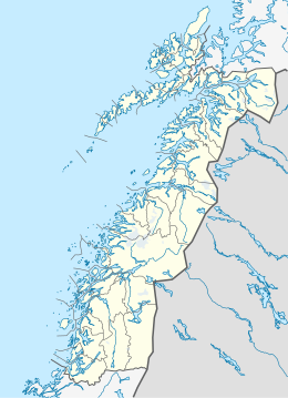
Alstahaug is a municipality in Nordland county, Norway. It is part of the Helgeland region. The administrative centre of the municipality is the town of Sandnessjøen. Some of the villages in Alstahaug include Søvika and Tjøtta.

Andøya is the northernmost island in the Vesterålen archipelago, situated about 300 kilometres (190 mi) inside the Arctic circle. Andøya is located in Andøy Municipality in Nordland county, Norway. The main population centres on the island include the villages of Andenes, Bleik, and Risøyhamn.

Eidvatnet or Eidevatnet is a lake that is located in Bindal Municipality in Nordland county, Norway. The 2-square-kilometre (0.77 sq mi) lake lies in the northern part of Bindal that is very sparsely populated. The lake Fjellvatnet flows to the southwest into this lake.

Øyungen is a lake in the municipality of Holtålen in Trøndelag county, Norway. The 6.13-square-kilometre (2.37 sq mi) lake lies about 7 kilometres (4.3 mi) southwest of the village of Hessdalen. The Forollhogna National Park surrounds the lake on three sides.
Hoklingen is a lake in the municipality of Levanger in Trøndelag county, Norway. The 6.1-square-kilometre (2.4 sq mi) lake lies just to the east of the village of Åsen and about 6 kilometres (3.7 mi) south of the village of Skogn.

Sula is an island in the municipality of Solund in Sogn og Fjordane county, Norway. The 116-square-kilometre (45 sq mi) island is the main island of the municipality. The island is located at the mouth of the Sognefjorden on the north side of the Sognesjøen, about 18 kilometres (11 mi) east of Holmebåen, the westernmost point in Norway. The largest village on the island is Hardbakke. The other main village area is Hersvikbygda on the northern part of the island.
Moskenesøya is an island at the southern end of the Lofoten archipelago in Nordland county, Norway. The 186-square-kilometre (72 sq mi) island is shared between Moskenes Municipality and Flakstad Municipality.
Froan or Froøyene is a populated archipelago of small, rocky islands in the municipality of Frøya in Trøndelag county, Norway. Froan consists of several hundred islands and islets that lie in the sea about 30 kilometres (19 mi) west of the Fosen peninsula. The islands run for about 40 kilometres (25 mi) in a northeasterly direction, parallel to the coastline. The island village of Halten lies at the northern end of the island chain. Only a few of the islands are inhabited, and in 2017, the population was only 38. The Froan Chapel, built in 1904, is located on the island of Sauøya. The Halten Lighthouse and others are located throughout the islands.
Garten is a populated island in the municipality of Ørland in Trøndelag county, Norway. The island is located on the north side of the mouth of the Trondheimsfjorden, just southwest of the mainland. The 1.5-square-kilometre (370-acre) island lies about 2 kilometres (1.2 mi) southeast of the island of Storfosna. The main population center on the island is also referred to as the village of Garten.
Bouvet Island is an uninhabited subantarctic high island and dependency of Norway located in the South Atlantic Ocean at 54°25′S3°22′E, thus locating it north of and outside the Antarctic Treaty System. It lies at the southern end of the Mid-Atlantic Ridge and is the most remote island in the world, approximately 1,700 kilometres (1,100 mi) north of the Princess Astrid Coast of Queen Maud Land, Antarctica, 1,160 kilometres (720 mi) east of the South Sandwich Islands and 2,600 kilometres (1,600 mi) south-southwest of the coast of South Africa.
Norway has three dependent territories, all uninhabited and located in the Southern Hemisphere. Bouvetøya is a Subantarctic island in the South Atlantic Ocean. Queen Maud Land is a sector of Antarctica which spans between 20° west and 45° east. Peter I Island is a volcanic island located 450 kilometres (280 mi) off the coast of Ellsworth Land of continental Antarctica.

Gåsvær is an island group in the municipality of Herøy in Nordland county, Norway. It is located about 15 kilometres (9.3 mi) northwest of the municipal center of Silvalen. The main islands in the group include Nordgåsvær, Sørgåsvær, Flatøya, and Innerodden. Gåsvær Chapel is located on Sørgåsvær island. Ytterholmen Lighthouse lies about 15 kilometres (9.3 mi) southwest of Gåsvær.
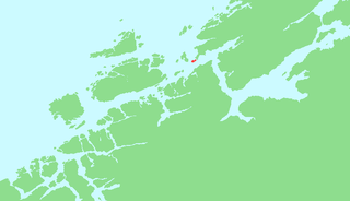
Sandværet is an island group in the municipality of Herøy in Nordland county, Norway. The islands are located about 17 kilometres (11 mi) southwest of the municipal center of Silvalen and about 5 kilometres (3.1 mi) west of the island of Husvær. The main populated islands in the group include Nordøya, Innerøya, Ytterøya, Langøya, and Gråøya. Sandvær Chapel serves the islands and has several worship services each year.
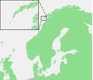
Husvær Chapel is a chapel of the Church of Norway in Herøy Municipality in Nordland county, Norway. It is located in the Husvær island group. It is an annex chapel in the Herøy parish which is part of the Nord-Helgeland prosti (deanery) in the Diocese of Sør-Hålogaland. The wooden chapel was built in a long church style in 1936 by the architects Otto Edvardsen and Peder Andersen. The chapel seats about 80 people.
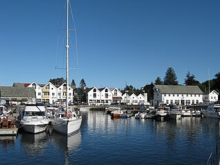
Toftøya or Toftarøyna is an island in Sund municipality in Hordaland county, Norway. The 9.1-square-kilometre (3.5 sq mi) island lies just south of the large island of Sotra, along the northern side of the Korsfjorden. The village of Klokkarvik lies about 5 kilometres (3.1 mi) northeast of the island. The island is connected to Sotra by a bridge on County Road 200. The island has 3 main village areas: Hummelsund, Vikso, and Tofta.