
New Salem is a village in Pike County, Illinois, United States. The population was 136 at the 2000 census.

Schwabing is a borough in the northern part of Munich, the capital of the German state of Bavaria. It is part of the city borough 4 (Schwabing-West) and the city borough 12 (Schwabing-Freimann). The population of Schwabing is estimated at about 100,000, making it one of the largest districts of Munich. The main boulevard is Leopoldstraße. (For further information on the Munich boroughs, see Boroughs of Munich.)

Basildon United Football Club is a football club based in Basildon, Essex. They are currently members of the Isthmian League North Division and play at Gardiners Close.

The Komoé River or Comoé River is a river in West Africa. The river originates on the Sikasso Plateau of Burkina Faso, flow through the Cascades de Karfiguéla, forms a short section of the border between Burkina Faso and Ivory Coast until it enters Ivory Coast, where it is the major drainage for northeastern portion of that country before emptying into the Atlantic. The banks of the Komoé are shaded by riparian forests along most of it length providing an important habitat for wildlife and a source of agricultural water. Where reliable floodplains form in Ivory Coast, rice may be grown. A portion of the river in northern Ivory Coast is the source of the vegetative richness that earned that area a UNESCO World Heritage Site designation, Comoé National Park.

Moutfort (French) is a village in the commune of Contern, in south-western Luxembourg, on both sides of the road from the city of Luxembourg to the German border town Remich. As of 2015, the village of Moutfort had a population of 1,306 inhabitants, and the associated village of Medingen had 112 inhabitants.
Buise was one of the East Frisian Islands off the North Sea coast of Germany that was almost entirely engulfed by the sea in the second half of the 17th century. The only remaining part is the eastern end, known today as the island of Norderney. Buise itself was formed by the breakup of a bigger island. Two possible origins are mentioned: the breakup of the island Burchana in the flood of 1219, and the breakup of the island Bant in 1170, which also formed Juist, Borkum and Memmert.

Kneehill County is a municipal district in central Alberta, Canada within Census Division No. 5.
Duntara is a town located north west of Catalina, Newfoundland and Labrador. Duntara was an Incorporated Community on October 21, 1961.

The Chiemgau Alps are a mountain range in the Northern Limestone Alps and belong to the Eastern Alps. Their major part is situated in Bavaria, Germany and only a small section crosses the Austrian border into the states of Salzburg and Tirol. They reach their highest elevation (1961 m) in the Sonntagshorn, a peak straddling the German-Austrian border.
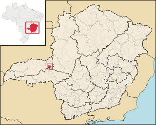
Romaria is a Brazilian municipality located in the northwest of the state of Minas Gerais. Its population as of 2020 was 3,520 people living in a total area of 402 km². The city belongs to the mesoregion of Triângulo Mineiro e Alto Paranaiba and to the microregion of Patrocínio. It became a municipality in 1962.
Tousseguela is a small town and commune in the Cercle of Kolondieba in the Sikasso Region of southern Mali. In 1998 the commune had a population of 4894.
Trzynik is a village in the administrative district of Gmina Siemyśl, within Kołobrzeg County, West Pomeranian Voivodeship, in north-western Poland. It lies approximately 5 kilometres (3 mi) south-east of Siemyśl, 18 km (11 mi) south of Kołobrzeg, and 93 km (58 mi) north-east of the regional capital Szczecin.
Wieńkowo is a village in the administrative district of Gmina Police, within Police County, West Pomeranian Voivodeship, in north-western Poland, close to the German border.
Vitkovac is a village in the municipality of Aleksinac, Serbia. According to the 2002 census, the village has a population of 398 people.
Sepaküla is a village in Põhja-Pärnumaa Parish, Pärnu County in southwestern Estonia.

Ostrovo is a village in the municipality of Kostolac, city of Požarevac, Serbia. According to the 2002 census, the village has a population of 685 people.
Sofielunds industriområde is a neighbourhood of Malmö, situated in the Borough of Södra Innerstaden, Malmö Municipality, Skåne County, Sweden.
Prekodolce is a village in the municipality of Vladičin Han, Serbia. According to the 2002 census, the village had a population of 1,625 people.
Stadionområdet is an area in Malmö, Sweden. The area is the home of two major stadiums, an ice hockey arena, an indoors arena, and several training facilities for association football, ice hockey and track and field sports.
