Interstate 96 (I-96) is an east–west Interstate Highway that runs for approximately 192 miles (309 km) entirely within the Lower Peninsula of the US state of Michigan. The western terminus is at an interchange with US Highway 31 (US 31) and Business US 31 on the eastern boundary of Norton Shores southeast of Muskegon, and the eastern terminus is at I-75 near the Ambassador Bridge in Detroit. From Grand Rapids through Lansing to Detroit, the freeway parallels Grand River Avenue, never straying more than a few miles from the decommissioned US 16. The Wayne County section of I-96 is named the Jeffries Freeway from its eastern terminus to the junction with I-275 and M-14. Though maps still refer to the freeway as the Jeffries, the portion within the city of Detroit was renamed by the state legislature as the Rosa Parks Memorial Highway in December 2005 in honor of the late civil rights pioneer. There are four auxiliary Interstates as well as two current and four former business routes associated with I-96.
M-5, commonly referred to as Grand River Avenue and the northern section as the Haggerty Connector, is a 20.807-mile-long (33.486 km) state trunkline highway in the Metro Detroit area of the US state of Michigan. The highway runs through suburbs in Oakland and Wayne counties in addition to part of Detroit itself. It starts in Commerce Township as a north–south divided highway and freeway called the Haggerty Connector and connects with Interstate 96 (I-96) in Novi. The freeway then turns southeasterly to bypass the suburb of Farmington as an east–west highway. The freeway ends on the southeast side of Farmington, and M-5 follows Grand River Avenue as boulevard into Detroit. The eastern terminus is at the five-way intersection between Grand River Avenue, Cass Avenue, and Middle Street in Downtown Detroit, where it had been extended to in May 2016 from an interchange with I-96 on the northwest side of the city. The trunkline passes between suburban residential subdivisions and along urban commercial areas while serving 17,200–68,800 vehicles on average each day.

The Minuteman Bikeway is a 10-mile (16-kilometre) paved multi-use rail trail located in the Greater Boston area of Massachusetts. It runs from Bedford to Alewife station, at the northern end of the Red Line in Cambridge, passing through the towns of Lexington and Arlington along the way. Also along the route are several notable regional sites, including Alewife Brook Reservation, the Cyrus Dallin Art Museum, Spy Pond, "Arlington’s Great Meadows", the Battle Green in Lexington, and Hanscom Air Force Base.
M-6, or the Paul B. Henry Freeway, is a 19.7-mile-long (31.7 km) east–west freeway and state trunkline highway in the United States that serves portions of southern Kent and eastern Ottawa counties south of Grand Rapids, Michigan. Although the freeway is named for Paul B. Henry, local residents and the press continue to use the original name, South Beltline as well on occasion. The freeway connects Interstate 196 (I-196) on the west with I-96 on the east. M-6 also provides a connection to U.S. Highway 131 (US 131) in the middle of its corridor while running through several townships on the south side of the Grand Rapids metropolitan area in Western Michigan. Each end is in a rural area while the central section has suburban development along the trunkline.
Interstate 375 (I-375) is a north-south Interstate Highway in the city of Detroit, Michigan, United States. It is the southernmost leg of the Walter P. Chrysler Freeway and a spur of I-75 into downtown Detroit, ending at the unsigned Business Spur Interstate 375, better known as Jefferson Avenue. The freeway opened on June 12, 1964. At only 1.062 miles (1.71 km) in length, it once had the distinction of being the shortest signed Interstate Highway in the country before I-110 in El Paso, Texas, was signed. The Michigan Department of Transportation (MDOT) announced in 2013 that it may remove I-375 in the future.
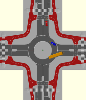
Interstate 275 (I-275) is an Interstate in the US state of Michigan that acts as a western bypass of the Detroit metropolitan area. The Michigan Department of Transportation (MDOT) maintains the highway as part of the larger state trunkline highway system. The freeway runs through the western suburbs near Detroit Metropolitan Wayne County Airport, and crosses several rivers and rail lines in the area. The southern terminus is the interchange with I-75 near Newport, northeast of Monroe. MDOT considers the Interstate to run to an interchange with I-96, I-696 and M-5 on the Farmington Hills–Novi city line, running concurrently with I-96 for about five miles (8.0 km). This gives a total length of about 35.03 miles (56.38 km), which is backed up by official signage. According to the Federal Highway Administration (FHWA), the length is 29.97 miles (48.23 km) because that agency considers I-275 to end at the junction with I-96 and M-14 along the boundary between Livonia and Plymouth Township. All other map makers, like the American Automobile Association, Rand McNally and Google Maps follow MDOT's practice.
Bicycle transportation planning and engineering are the disciplines related to transportation engineering and transportation planning concerning bicycles as a mode of transport and the concomitant study, design and implementation of cycling infrastructure. It includes the study and design of dedicated transport facilities for cyclists as well as mixed-mode environments and how both of these examples can be made to work safely. In jurisdictions such as the United States it is often practiced in conjunction with planning for pedestrians as a part of active transportation planning.

The Coyote Creek bikeway is a Class 1 bike path in Los Angeles County that runs adjacent to the Coyote Creek flood control channel for approximately 9.5 miles. The bike path is controlled by Caltrans. The path begins in Santa Fe Springs on the North fork of the Coyote Creek and extends south into Long Beach where it joins the San Gabriel River bicycle path at the trail bridge just South of Willow Street/Katella Avenue.

A bicycle boulevard, sometimes referred to as a neighborhood greenway, neighborway, neighborhood bikeway or neighborhood byway is a type of bikeway composed of a low-speed street which has been "optimized" for bicycle traffic. Bicycle boulevards discourage cut-through motor-vehicle traffic but allow local motor-vehicle traffic. They are designed to give priority to bicyclists as through-going traffic. They are intended as a low-cost, politically popular way to create a connected network of streets with good bicyclist comfort and/or safety.

The Manhattan Waterfront Greenway is a waterfront greenway for walking or cycling, 32 miles (51 km) long, around the island of Manhattan, in New York City. The largest portions are operated by the New York City Department of Parks and Recreation. It is separated from motor traffic, and many sections also separate pedestrians from cyclists. There are three principal parts — the East, Harlem and Hudson River Greenways.
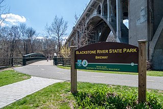
The Blackstone River Greenway is a partially completed 48-mile (77 km) paved rail trail defining the course of the East Coast Greenway through the Blackstone Valley from Worcester, Massachusetts to Providence, Rhode Island.
The Greenways Alliance of Rhode Island was a non-profit organization dedicated to advocacy for Rhode Island's bike paths, trails and greenspaces. It also served as the state committee of the East Coast Greenway. In Spring 2010, GARI merged with the Providence Bicycle Coalition to become the Rhode Island Bicycle Coalition.
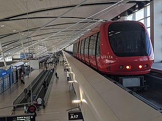
Transportation in metropolitan Detroit is provided by a system of transit services, airports, and an advanced network of freeways which interconnect the city of Detroit and the Detroit region. The Michigan Department of Transportation (MDOT) administers the region's network of major roads and freeways. The region offers mass transit with bus services provided jointly by the Detroit Department of Transportation (DDOT) and the Suburban Mobility Authority for Regional Transportation (SMART) through a cooperative service and fare agreement administered by the Regional Transit Authority (RTA). Cross border service between the downtown areas of Windsor and Detroit is provided by Transit Windsor via the Tunnel Bus. A monorail system, known as the People Mover, operates daily through a 2.94 mile (4.7 km) loop in the downtown area. A proposed SEMCOG Commuter Rail could link New Center, Dearborn, Detroit Metropolitan Airport, and Ann Arbor with access to DDOT and SMART buses. Amtrak's current passenger facility is north of downtown in the New Center area. Amtrak provides service to Detroit, operating its Wolverine service between Chicago, Illinois, and Pontiac. Greyhound Lines operates a station on Howard Street near Michigan Avenue. The city's dock and public terminal receives cruise ships on International Riverfront near the Renaissance Center which complements tourism in metropolitan Detroit.

Detroit is a popular city for cycling. It is flat with an extensive road network with a number of recreational and competitive opportunities and is, according to cycling advocate David Byrne, one of the top eight biking cities in the world. The city has invested in greenways and bike lanes and other bicycle-friendly infrastructure. Bike rental is available from the riverfront and tours of the city's architecture can be booked.

This is a list of trails and greenways in Detroit.
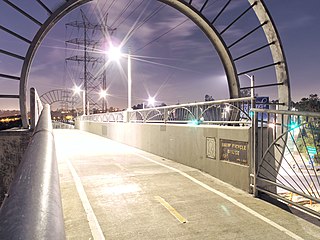
The Los Angeles River bicycle path is a Class I bicycle and pedestrian path in the Greater Los Angeles area running from north to east along the Los Angeles River through Griffith Park in an area known as the Glendale Narrows. The 7.4 mile section of bikeway through the Glendale Narrows is known as the Elysian Valley Bicycle & Pedestrian Path. The bike path also runs from the city of Vernon to Long Beach, California. This section is referred to as the Los Angeles River Bikeway.

Cycling infrastructure refers to all infrastructure permissible for use by cyclists, including the network of roads and streets used by motorists, except where cyclists are excluded, along with bikeways from which motor vehicles are excluded – including bike paths, bike lanes, cycle tracks, rail trails and, where permitted, sidewalks. Cycling infrastructure also includes amenities such as bike racks for parking, shelters, service centers and specialized traffic signs and signals. Cycling modal share is strongly associated with the size of local cycling infrastructure.

The Western Gwinnett Bikeway is a multi-use trail under construction along Peachtree Industrial Boulevard in Gwinnett County. The trail will be 10 feet to 14 feet wide and traverse the cities of Norcross, Peachtree Corners, Berkeley Lake, Duluth, Suwanee, Sugar Hill and Buford. It is intended to be the spine of West Gwinnett’s trails and greenways, connecting parks, trails, businesses, schools and neighborhoods to the urban core.
