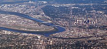
Kansas City is the largest city in the U.S. state of Missouri. According to the U.S. Census Bureau, the city had an estimated population of 488,943 in 2017, making it the 37th most-populous city in the United States. It is the central city of the Kansas City metropolitan area, which straddles the Kansas–Missouri state line. Kansas City was founded in the 1830s as a Missouri River port at its confluence with the Kansas River coming in from the west. On June 1, 1850 the town of Kansas was incorporated; shortly after came the establishment of the Kansas Territory. Confusion between the two ensued and the name Kansas City was assigned to distinguish them soon after.

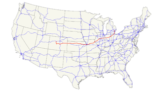
Interstate 70 (I-70) is a major east–west Interstate Highway in the United States that runs from I-15 near Cove Fort, Utah, to I-695 near Baltimore, Maryland. I-70 approximately traces the path of U.S. Route 40 east of the Rocky Mountains. West of the Rockies, the route of I-70 was derived from multiple sources. The Interstate runs through or near many major cities, including Denver, Kansas City, St. Louis, Indianapolis, Columbus, Pittsburgh, and Baltimore.

The Katy Trail State Park is a state park in the U.S. state of Missouri that contains the Katy Trail, a recreational rail trail that runs 240 miles (390 km) in the right-of-way of the former Missouri–Kansas–Texas Railroad. Running largely along the northern bank of the Missouri River, it is the country's longest rails-to-trails trail. The trail is open for use by hikers, joggers, and cyclists year-round, from sunrise to sunset. Its hard, flat surface is of "limestone pug".
U.S. Route 24 is one of the original United States highways of 1926. It originally ran from Pontiac, Michigan, in the east to Kansas City, Missouri, in the west. Today, the highway's northern terminus is in Independence Township, Michigan, at an intersection with I-75 and its western terminus is near Minturn, Colorado at an intersection with I-70. The highway transitions from north–south to east–west signage in Toledo, Ohio.
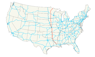
U.S. Route 71 is a major north–south United States highway that extends for over 1500 miles in the central United States. This original 1926 route has remained largely unchanged by encroaching Interstate highways. Currently, the highway's northern terminus is in International Falls, Minnesota at the Canada–US border, at the southern end of the Fort Frances-International Falls International Bridge to Fort Frances, Ontario. U.S. Route 53 also ends here. On the other side of the bridge, Trans-Canada Highway 11 is an east–west route. US 71's southern terminus is between Port Barre and Krotz Springs, Louisiana at an intersection with U.S. Route 190.

The Kansas City metropolitan area is a 14 county metropolitan area anchored by Kansas City, Missouri, and straddling the border between the U.S. states of Missouri and Kansas. With a population of 2,104,509, it ranks as the second largest metropolitan area centered in Missouri. Alongside Kansas City, the area includes a number of other cities and suburbs, the largest being Overland Park, Kansas; Kansas City, Kansas; Olathe, Kansas; and Independence, Missouri; each over 100,000 in population. The Mid-America Regional Council (MARC) serves as the Council of Governments and the Metropolitan Planning Organization for the area.
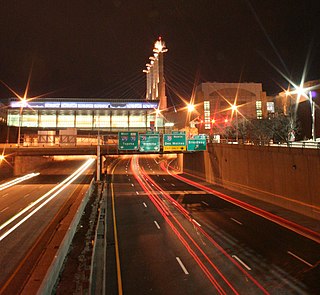
The Downtown Loop is a complex layout of highways in downtown Kansas City, Missouri involving 23 exits, four Interstate Highways, four U.S. Highways and numerous city streets. Each exit in the highway loop is numbered 2 and suffixed with every letter of the alphabet except I, O, and Z. The entire circumference of the loop is just over 4 miles (6.4 km).

The River Market is a riverfront neighborhood in Kansas City, Missouri that comprises the first and oldest incorporated district in Kansas City. According to statisticalatlas.com the population was 1,350.
The Blue River is a 39.8-mile-long (64.1 km) stream that flows through Johnson County, Kansas, and Jackson County, Missouri, in the Kansas City Metropolitan Area. The river rises in Johnson County near the border of the states of Kansas and Missouri. Crossing the city of Kansas City, Missouri, it empties into the Missouri River near the border between Kansas City and Independence, Missouri.
Route 45 is a highway in northwest Missouri in Buchanan County, Missouri and Platte County, Missouri which is largely in the bottom land alongside of the Missouri River.
Interstate 670 (I-670) is a 2.81 mile (4.52 km) connector highway between I-70 in Kansas City, Kansas and I-70 in Kansas City, Missouri. The highway provides a more direct route through downtown Kansas City than the older mainline I-70, and avoids the sharp turn of the latter at the west end of the Intercity Viaduct. I-670 is also designated Alternate Interstate 70, one of the few interstates to be designated as an alternate.
Interstate 670 also makes up the south side of Kansas City's downtown freeway loop, where it passes under the southern half of Bartle Hall Convention Center.
The Kansas City Stockyards in the West Bottoms west of downtown Kansas City, Missouri flourished from 1871 until closing in 1991.
Jay B. Dillingham was the President of the stockyards from 1948 to its closing in 1991.
Jay B. Dillingham was a former president of the Kansas City Stockyards as well as former president of the Chamber of Commerce for both Kansas City, Missouri and Kansas City, Kansas.
In the U.S. state of Kansas, Interstate 70 contains the first segment to start being paved and to be completed in the Interstate Highway System. It extends from the Colorado border near the town of Kanorado to the Missouri border in Kansas City. The route covers 424 miles (682 km) and passes through several of the state's principal cities in the process including Kansas City, Topeka, and Salina. The route also passes through the cities of Lawrence, Junction City, and Abilene.
In the U.S. state of Missouri, Interstate 70 (I-70) is generally parallel to the Missouri River. This section of the transcontinental Interstate begins at the Kansas state line on the Lewis and Clark Viaduct, concurrent with U.S. Routes 24, 40, and 169, and the east end is on the Stan Musial Veterans Memorial Bridge in St. Louis.

The Pencoyd Railroad Bridge is a former railroad bridge in Kansas City, Missouri, that was converted into the Freight House Pedestrian Bridge and moved to its new location where it connects Union Station and the Crossroads Arts District.

The Intercity Viaduct is an automobile and pedestrian crossing of the Kansas River in the United States. Designed by Waddell and Hedrick, this four lane, two level deck truss bridge was built in 1907. It rises above the West Bottoms, and several sets of railroad tracks. It was the first roadway bridge to connect Kansas City, Missouri, with Kansas City, Kansas, non-stop all the way across. It is about 1.5 miles (2.4 km) long and carries eastbound traffic for Interstate 70 (I-70)/U.S. Route 24 (US 24)/US 40/US 169, while its sister bridge, the Lewis and Clark Viaduct, built in 1962, carries westbound traffic.
Truman Road, Truman, or 15th Street is a major east/west road in Jackson County, Missouri. It serves Kansas City, Missouri, Independence, and eastern unincorporated Jackson County.
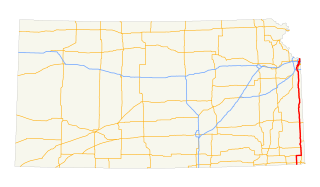
U.S. Route 69 (US-69) is a major north-south U.S. Highway that runs from Port Arthur, Texas to Albert Lea, Minnesota. In Kansas, the highway runs in the far eastern part of the state, usually within 5 miles of the Missouri state line. Most of the highway north of Fort Scott runs as a freeway.