Iceboro, Maine

Last updated

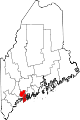
Iceboro is a village in the town of Richmond in Sagadahoc County, Maine, United States. The village is located at an altitude of 135 feet (41 m). [1] The community had a post office from 1882 to 1905. [2]

Unincorporated area Region of land not governed by own local government

In law, an unincorporated area is a region of land that is not governed by a local municipal corporation; similarly an unincorporated community is a settlement that is not governed by its own local municipal corporation, but rather is administered as part of larger administrative divisions, such as a township, parish, borough, county, city, canton, state, province or country. Occasionally, municipalities dissolve or disincorporate, which may happen if they become fiscally insolvent, and services become the responsibility of a higher administration. Widespread unincorporated communities and areas are a distinguishing feature of the United States and Canada. In most other countries of the world, there are either no unincorporated areas at all, or these are very rare; typically remote, outlying, sparsely populated or uninhabited areas.

New England town Basic unit of local government in each of the six New England federated states of the United States

The New England town, generally referred to simply as a town in New England, is the basic unit of local government and local division of state authority in each of the six New England states and without a direct counterpart in most other U.S. states. New England towns overlay the entire area of a state, similar to civil townships in other states where they exist, but they are fully functioning municipal corporations, possessing powers similar to cities in other states. New Jersey's system of equally powerful townships, boroughs, towns, and cities is the system which is most similar to that of New England. New England towns are often governed by a town meeting legislative body. The great majority of municipal corporations in New England are based on the town model; statutory forms based on the concept of a compact populated place are uncommon, though they are prevalent elsewhere in the U.S. County government in New England states is typically weak at best, and in some states nonexistent. Connecticut, for example, has no county governments, nor does Rhode Island. Both of those states retain counties only as geographic subdivisions with no governmental authority, while Massachusetts has abolished eight of fourteen county governments so far. With few exceptions, counties serve mostly as dividing lines for the states' judicial systems.

Richmond, Maine Town in Maine, United States

Richmond is a town in Sagadahoc County, Maine, United States. The population was 3,411 at the 2010 census. It is part of the Portland–South Portland–Biddeford, Maine metropolitan statistical area.

Related Research Articles

Au Train Township, Michigan Civil township in Michigan, United States

Au Train Township is a civil township of Alger County in the U.S. state of Michigan. As of the 2010 census, the township population was 1,138.

Hibberts Corner is a village within the town of Washington in Knox County, Maine, United States. It is located at 44°18′15″N69°24′26″W, at an altitude of 354 feet (108 m).

Betsie River river in United States of America

The Betsie River is a 54.0-mile-long (86.9 km) stream in the northwest part of the U.S. state of Michigan. The name is derived from the French la rivière aux Bec-scies, meaning river of sawbill ducks (bec-scie). Other alternate names include Aug-sig-o-sebe, Aux Buscies, Betsey's River, Black Robe, Gay-she-say-ing, Riviere du Pere Marquette, Sawbill Ducks, and Shelldrake Ducks. The river is mostly within Benzie County, although the river rises in southwest Grand Traverse County and flows briefly through northern Manistee County, Michigan.

Waco, Ohio human settlement in Ohio, United States of America

Waco is an unincorporated community in central Canton Township, Stark County, Ohio, United States. It lies along State Route 43 just southeast of the Canton city line. Waco's altitude is 1,070 feet (326 m) The community is part of the Canton–Massillon Metropolitan Statistical Area.

South Chesconessex, Virginia human settlement in United States of America

South Chesconessex is a census-designated place (CDP) in Accomack County, Virginia, United States. The population as of the 2010 Census was 131.

The Abagadasset River is a 16.0-mile-long (25.7 km) river in Richmond and Bowdoinham, Maine, flowing into Merrymeeting Bay, part of the estuary of the Kennebec River.

The East Branch Eastern River is a 6.5-mile-long (10.5 km) river in Maine. It is part of the Kennebec River watershed. It rises in the town of Whitefield and flows southwest to its confluence with the West Branch Eastern River at East Pittston to form the Eastern River.

The East Branch Sebasticook River is a tributary of the Sebasticook River in central Maine in the United States. It is part of the Kennebec River watershed. From the outflow of Lake Wassookeag in Dexter, the river runs about 12.7 miles (20.4 km) south to Sebasticook Lake. From the outflow of the lake in Newport, the river runs about 9.5 miles (15.3 km) southwest to its confluence with the Sebasticook in Detroit.

The Eastern River is a 14.0-mile-long (22.5 km) tributary of the Kennebec River in Maine. It rises in East Pittston at the confluence of its west and east branches and flows southwest past Dresden Mills to its mouth at the Kennebec, at the town boundary between Dresden and Perkins.

The Little River is a tidal channel connecting at each end with the Kennebec River in the town of Perkins in the U.S. state of Maine. It passes to the west of Little Swan Island while the main stem of the Kennebec passes to the east.

The North Branch Marsh River is a 1.0-mile-long (1.6 km) tidal river in the town of Frankfort, Waldo County, Maine. It is a tributary of Marsh Bay, an arm of the tidal Penobscot River.

The West Branch Eastern River is a 10.4-mile-long (16.7 km) tributary of the Eastern River in Maine. It is part of the Kennebec River watershed. The West Branch begins near South Windsor and flows southwest through the town of Whitefield, joining the East Branch at East Pittston to form the Eastern River.

Huntly is an unincorporated community in Rappahannock County, in the U.S. state of Virginia.

New Harrison is an unincorporated community in Darke County, in the U.S. state of Ohio.

Blue Spring is an unincorporated community in Randolph County, in the U.S. state of West Virginia.

The chain of Debsconeag Lakes in the North Maine Woods is a tributary to the West Branch Penobscot River. The flow sequence is from the Sixth Debsconeag Lake through the Fifth, Fourth, Third, Second, and First into the Debsconeag Deadwater on the West Branch.

Lavender is an unincorporated community in Kittitas County, in the U.S. state of Washington.

Minkler is an unincorporated community in Skagit County, in the U.S. state of Washington.

Salt Springs is an unincorporated community in Saline County, in the U.S. state of Missouri.

Ladd is an unincorporated community in northwestern Texas County, in the U.S. state of Missouri.

References

Coordinates: 44°06′44″N69°46′43″W / 44.11222°N 69.77861°W / 44.11222; -69.77861

Geographic coordinate system Coordinate system

A geographic coordinate system is a coordinate system that enables every location on Earth to be specified by a set of numbers, letters or symbols. The coordinates are often chosen such that one of the numbers represents a vertical position and two or three of the numbers represent a horizontal position; alternatively, a geographic position may be expressed in a combined three-dimensional Cartesian vector. A common choice of coordinates is latitude, longitude and elevation. To specify a location on a plane requires a map projection.