Related Research Articles

Svalbard, also known as Spitsbergen or Spitzbergen in Dutch, is a Norwegian archipelago in the Arctic Ocean. North of mainland Europe, it lies about midway between the northern coast of Norway and the North Pole. The islands of the group range from 74° to 81° north latitude, and from 10° to 35° east longitude. The largest island is Spitsbergen, followed in size by Nordaustlandet and Edgeøya. The largest settlement is Longyearbyen on the west coast of Spitsbergen.

Longyearbyen is the world's northernmost settlement with a population greater than 1,000 and the largest inhabited area of Svalbard, Norway. It stretches along the foot of the left bank of the Longyear Valley and on the shore of Adventfjorden, the short estuary leading into Isfjorden on the west coast of Spitsbergen, the island's broadest inlet. As of 2002 Longyearbyen Community Council became an official Norwegian municipality. It is the seat of the Governor of Svalbard. The town's mayor is Arild Olsen.
Barentsburg is the second-largest settlement in Svalbard, Norway, with about 455 inhabitants (2020). A coal mining town, the settlement was almost entirely made up of ethnic Russians and Ukrainians. With the 2022 Russian invasion of Ukraine, most of the Ukrainian citizens were reported to have left.
The Svalbard Rocket Range or SvalRak as it is named, is a launch site for sounding rockets at Ny-Ålesund in Svalbard, Norway. The site has been in use since 1997 and is owned by Andøya Space Center, which is owned by the Norwegian Ministry of Trade, Industry and Fisheries and the Kongsberg Group. SvalRak's location at the 79th parallel north makes it well-suited for launching rockets to investigate Earth's magnetic field. It is used mostly by American, Japanese and Norwegian researchers. It is the world's northernmost launch site.

Adventfjorden is a 7 km long and 4 km wide bay running south-eastwards from the southern side of Isfjorden, on the west coast of Spitsbergen in Svalbard. The name represents a corruption of Adventure Bay - probably named after the Hull-built whaleship Adventure, which operated in Isfjorden in 1656. The fjord was originally known as Klass Billen Bay. At the head of Adventfjorden is Adventdalen.
James I Land is a land area on the northwestern part of Spitsbergen, Svalbard. It is named after King James I of England and Scotland. The 30 kilometer long glacier Sveabreen divides James I Land from Oscar II Land.
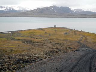
Finneset is a peninsula located on the east side of Grønfjorden on Spitsbergen in Svalbard, Norway. It is located 2 kilometers (1.2 mi) south of Barentsburg. A whaling station was located there until 1905. From 1911 it became the site of the first wireless station in the Arctic, named Svalbard Radio from 19 September 1925. It was also a meteorological station operated by the Norwegian Meteorological Institute. Both services moved to Longyearbyen on 1 September 1930. It is named for being a fine place to land a ship.

The Longyear Valley is a valley and ravine in Svalbard. It slightly winds 40 kilometres (25 mi) WNW ending in Adventfjorden, facing west, the broadest inlet of Spitsbergen, the main landmass. It has a few wind gaps to the south and north-east over small glaciers, under which small streams form. It is between mountains Platåberget and Gruvefjellet. The town of Longyearbyen is at its foot, which is named for the American industrialist John Munroe Longyear. The Longyear River is, like all the island's rivers, silted from surrounding glaciers.

The Longyear River is a river which runs through the Longyear Valley, passing through the town of Longyearbyen and draining into Adventfjorden on the island of Spitsbergen in Svalbard, Norway. It is named for the American industrialist John Munroe Longyear.
St. Jonsfjorden is a fjord in Oscar II Land at Spitsbergen, Svalbard. It has a length of 21 kilometer, and opens westwards into the strait of Forlandsundet. Several glaciers debouche into the fjord, including Gaffelbreen and Konowbreen from the north, a merge of Osbornebreen, Devikbreen, Vintervegen, Paulbreen and Bukkebreen at the bottom, and Vegardbreen, Charlesbreen and Bullbreen from the south.
Colesbukta is a bay at the southern side of Isfjorden, in Nordenskiöld Land at Spitsbergen, Svalbard. The bay is about 4.5 kilometer wide. A railway for coal transport was earlier operated between Grumantbyen and shipment facilities in Colesbukta. The valley Colesdalen debouches into Colesbukta.
Colesdalen is a valley in Nordenskiöld Land at Spitsbergen, Svalbard. The valley debouches into the bay Colesbukta, at the southern side of Isfjorden.
Dahlbreen is a glacier in Oscar II Land at Spitsbergen, Svalbard. It is named after whaler Thor Dahl. The glacier has a length of about fifteen kilometers, extending from Løvenskioldfonna to Forlandsundet. Among its tributary glaciers are Ujamnbreen, Bærumbreen and Fjelgbreen. Retreatment of the glacier has formed the bay of Dahlbrebukta.

Linnédalen is a valley in Nordenskiöld Land at Spitsbergen, Svalbard. It is named after Swedish botanist Carl Linnaeus. The valley has a length of about ten kilometers, and is located east of the mountain ridge of Linnéfjella. In the lower part of the valley is the lake of Linnévatnet, which is among the largest lakes of Spitsbergen.
Linnéfjella is a mountain ridge in Nordenskiöld Land at Spitsbergen, Svalbard. It is named after Swedish botanist Carl Linnaeus. The ridge contains the mountains of Solryggen, Aagaardtoppen, Griegfjellet and Griegaksla. East of the ridge is the valley of Linnédalen.
Grimdalen is a valley at Barentsøya, Svalbard. It extends from Barentsjøkulen to Ginevra Bay, at the eastern side of Grimheia. The river of Grima flows through the valley.
Davisdalen is a valley in Nathorst Land at Spitsbergen, Svalbard. It is named after American geomorphologist William Morris Davis. The valley has a length of about 5.5 kilometers, extending from the mountain ridge of Mjellegga southwards down to Davisodden, at the northern side of Van Keulenfjorden. A tributary valley to Davisdalen is Wittrockdalen.
De Geerdalen is a valley in Nordenskiöld Land at Spitsbergen, Svalbard. It is named after Swedish geologist and Arctic explorer Gerard De Geer. The mountain pass of Kreklingpasset divides De Geerdalen from Helvetiadalen. The river of De Geerelva flows through the valley, and debouches into Sassenfjorden at Elveneset.
Sauriedalen is a valley in Dickson Land at Spitsbergen, Svalbard. It has a length of about sixteen kilometers, extending from Njordfjellet and Gyntflya to Tschermakfjellet. The valley is named from fossil Triassic reptiles (sauria), found in the nearby Saurieberget.
Kongressfjellet is a mountain in Dickson Land at Spitsbergen, Svalbard. It has a height of 605 m.a.s.l., and is located between the valleys of Idodalen (north) and Sauriedalen (east), and the mountain of Tschermakfjellet (south).
References
- ↑ "Idodalen (Svalbard)". Norwegian Polar Institute. Archived from the original on 4 March 2016. Retrieved 29 November 2015.
- ↑ "Idoelva (Svalbard)". Norwegian Polar Institute. Archived from the original on 8 December 2015. Retrieved 29 November 2015.
78°34′31″N15°23′38″E / 78.57516°N 15.39380°E
| | This Spitsbergen location article is a stub. You can help Wikipedia by expanding it. |