
West Flanders is the westernmost province of the Flemish Region, in Belgium. It is the only coastal Belgian province, facing the North Sea to the northwest. It has land borders with the Dutch province of Zeeland to the northeast, the Flemish province of East Flanders to the east, the Walloon province of Hainaut in the south and the French department of Nord to the west. Its capital is Bruges (Brugge). Other important cities are Kortrijk in the south and Ostend (Oostende) on the coast, Roeselare and Ypres (Ieper). The province has an area of 3,197 km2 (1,234 sq mi) which is divided into eight administrative districts (arrondissementen) containing 64 municipalities. As of January 2024, West Flanders has a population of over 1.22 million.
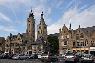
Diksmuide is a Belgian city and municipality in the Flemish province of West Flanders. The municipality comprises the city of Diksmuide proper and the former communes of Beerst, Esen, Kaaskerke, Keiem, Lampernisse, Leke, Nieuwkapelle, Oostkerke, Oudekapelle, Pervijze, Sint-Jacobs-Kapelle, Stuivekenskerke, Vladslo and Woumen.

Nieuwpoort is a city and municipality located in Flanders, one of the three regions of Belgium, in the province of West Flanders. The municipality comprises the town of Nieuwpoort proper, as well as Ramskapelle and Sint-Joris. On 1 January 2008, Nieuwpoort had a total population of 11,062. Its land area is 31.00 km² which gives a population density of 350 inhabitants per km². The current mayor of Nieuwpoort is Geert Vanden Broucke (CD&V)
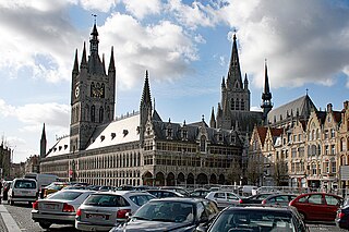
Ypres is a Belgian city and municipality in the province of West Flanders. Though the Dutch name Ieper is the official one, the city's French name Ypres is most commonly used in English. The municipality comprises the city of Ypres/Ieper and the villages of Boezinge, Brielen, Dikkebus, Elverdinge, Hollebeke, Sint-Jan, Vlamertinge, Voormezele, Zillebeke, and Zuidschote. Together, they are home to about 34,900 inhabitants.

The Yser is a river that rises in French Flanders, enters the Belgian province of West Flanders and flows through the Ganzepoot and into the North Sea at the town of Nieuwpoort.

The siege of Antwerp was an engagement between the German and the Belgian, British and French armies around the fortified city of Antwerp during the First World War. German troops besieged a garrison of Belgian fortress troops, the Belgian field army and the British Royal Naval Division in the Antwerp area, after the German invasion of Belgium in August 1914. The city, which was ringed by forts known as the National Redoubt, was besieged to the south and east by German forces.

The First Battle of Ypres was a battle of the First World War, fought on the Western Front around Ypres, in West Flanders, Belgium. The battle was part of the First Battle of Flanders, in which German, French, Belgian armies and the British Expeditionary Force (BEF) fought from Arras in France to Nieuwpoort (Nieuport) on the Belgian coast, from 10 October to mid-November. The battles at Ypres began at the end of the Race to the Sea, reciprocal attempts by the German and Franco-British armies to advance past the northern flank of their opponents. North of Ypres, the fighting continued in the Battle of the Yser (16–31 October), between the German 4th Army, the Belgian army and French marines.
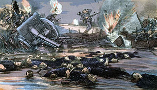
The Battle of the Yser was a battle of the First World War that took place in October 1914 between the towns of Nieuwpoort and Diksmuide, along a 35 km (22 mi) stretch of the Yser River and the Yperlee Canal, in Belgium. The front line was held by a large Belgian force, which halted the German advance in a costly defensive battle.

The Race to the Sea took place from about 17 September – 19 October 1914 during the First World War, after the Battle of the Frontiers and the German advance into France. The invasion had been stopped at the First Battle of the Marne (5–12 September) and was followed by the First Battle of the Aisne (13–28 September), a Franco-British counter-offensive. The term describes reciprocal attempts by the Franco-British and German armies to envelop the northern flank of the opposing army through the provinces of Picardy, Artois and Flanders, rather than an attempt to advance northwards to the sea. The "race" ended on the North Sea coast of Belgium around 19 October, when the last open area from Diksmuide to the North Sea was occupied by Belgian troops who had retreated after the Siege of Antwerp. The outflanking attempts had resulted in a number of encounter battles but neither side was able to gain a decisive victory.
The Ypres Salient, around Ypres, in Belgium, was the scene of several battles and a major part of the Western Front during World War I.

Operation Hush was a British plan for amphibious landings on the Belgian coast in 1917 during the First World War. The landings were to be combined with an attack from Nieuwpoort and the Yser bridgehead, left over since the Battle of the Yser in 1914. Plans were considered in 1915 and 1916, then shelved due to operations elsewhere.
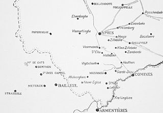
The Battle of Messines was fought in October 1914 between the armies of the German empire against the British empire and France, as part of what came to be called the Race to the Sea: reciprocal attempts by the German and Entente armies to attack beyond the northern flank of their opponent. The attempts to turn the northern flank led to several meeting engagements until the North Sea left neither side with a flank to aim at. The battle was fought between the river Douve and the Comines–Ypres canal.

The Battle of the Lys was a major battle between Belgian and German forces during the German invasion of Belgium of 1940 and the final major battle fought by Belgian troops before their surrender on 28 May. The battle was the bloodiest of the 18 Days' Campaign. The battle was named after the Leie, the river at which the battlefield occurred.

The German invasion of Belgium was a military campaign which began on 4 August 1914. On 24 July, the Belgian government had announced that if war came it would uphold its neutrality. The Belgian government mobilised its armed forces on 31 July and a state of heightened alert was proclaimed in Germany. On 2 August, the German government sent an ultimatum to Belgium, demanding passage through the country and German forces invaded Luxembourg. Two days later, the Belgian government refused the German demands and the British government guaranteed military support to Belgium. The German government declared war on Belgium on 4 August; German troops crossed the border and began the Battle of Liège.

Armand Léopold Théodore, Baron de Ceuninck was the Minister of War of Belgium, serving in the last year of World War I.

Essex Farm Cemetery is a World War I, Commonwealth War Graves Commission burial ground within the John McCrae Memorial Site near Ypres, Belgium. There are 1,204 dead commemorated, of which 104 are unidentified. The cemetery was designed by Sir Reginald Blomfield and has an area of 6,032 square metres (64,930 sq ft).

The Yser Front, sometimes termed the West Flemish Front in British writing, was a section of the Western Front during World War I held by Belgian troops from October 1914 until 1918. The front ran along the Yser river (IJzer) and Yser Canal (Ieperlee) in the far north-west of Belgium and defended a small strip of the country which remained unoccupied. The front was established following the Battle of the Yser in October 1914, when the Belgian army succeeded in stopping the German advance after months of retreat and remained largely static for the duration of the war.
Fort Knokke or Fort de Cnocke or Fort de la Knocque or Fort de Knocke was an important fortification that defended western Flanders from the 1580s until it was demolished in the 1780s. During its 200 year history, the place was held by the Spanish Empire, Kingdom of France, Habsburg Austria and the Dutch Republic. The existing defenses were improved in 1678 by the famous military engineer Sébastien Le Prestre de Vauban. The fort was attacked by the Grand Alliance in 1695 during the Nine Years' War but the French garrison successfully held out. It was captured from the French by a ruse in 1712 during the War of the Spanish Succession. Control of the fort and other strong places in the Austrian Netherlands was a key feature of the so-called Barrier Treaty in 1713. The French captured the fort after a two-month siege in 1744 during the War of the Austrian Succession. Emperor Joseph II had the citadel demolished in 1781. The site is on the Yser River about 8 kilometres (5 mi) southwest of Diksmuide, Belgium.
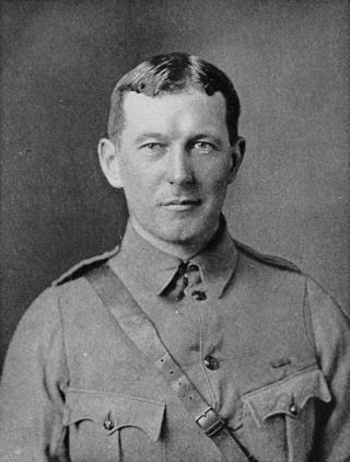
Site John McCrae is a World War I memorial site near Ypres, Belgium. It is named after the Canadian physician Lieutenant Colonel John McCrae, MD (1872–1918), author of the famous poem "In Flanders Fields", which he composed while serving at this site in 1915.

