Ignatiigränd

Last updated
Ignatiigrand in March 2007. Ignatiigrand March 2007.JPG
Ignatiigränd in March 2007.

Ignatiigränd is an alley in Gamla stan, the old town in central Stockholm, Sweden. Stretching from Västerlånggatan to Stora Nygatan, it forms a parallel street to Göran Hälsinges Gränd and Gåsgränd.

Alley narrow street

An alley or alleyway is a narrow lane, path, or passageway, often reserved for pedestrians, which usually runs between, behind, or within buildings in the older parts of towns and cities. It is also a rear access or service road, or a path, walk, or avenue in a park or garden.

Gamla stan urban district in Stockholm, Sweden

Gamla stan, until 1980 officially Staden mellan broarna, is the old town of Stockholm, Sweden. Gamla stan consists primarily of the island Stadsholmen. Officially, but not colloquially, Gamla stan includes the surrounding islets Riddarholmen, Helgeandsholmen, and Strömsborg.

Stockholm Capital city in Södermanland and Uppland, Sweden

Stockholm is the capital of Sweden and the most populous urban area in the Nordic countries; 962,154 people live in the municipality, approximately 1.5 million in the urban area, and 2.3 million in the metropolitan area. The city stretches across fourteen islands where Lake Mälaren flows into the Baltic Sea. Just outside the city and along the coast is the island chain of the Stockholm archipelago. The area has been settled since the Stone Age, in the 6th millennium BC, and was founded as a city in 1252 by Swedish statesman Birger Jarl. It is also the capital of Stockholm County.

Contents

History

The alley is called Mårten Klinks gränd ("Mårten Klink's alley") in 1606 in reference to a local proprietor and in 1661 it is referred to as Mårten Klinkas eller Ignatij Grendh ("Mårten Klink's or Ignatius's alley"). The latter was a famous printer named Ignatius Meurer (1589–1672) who was, according to a memorial verse found in the Royal Library, born in Blankenburg, Schwarzburg, Germany, immigrated to Stockholm in 1610 and eventually through marriage became the owner of a printing workshop and settled in the block north of the alley. He is known to have produced the city law of 1628, introducing the Antiqua typeface in Sweden. [1] [2] (See also Staffan Sasses Gränd.)

Bad Blankenburg Place in Thuringia, Germany

Bad Blankenburg is a spa town in the district of Saalfeld-Rudolstadt, in Thuringia, Germany. It is situated 6 km southwest of Rudolstadt, and 37 km southeast of Erfurt. It is most famous for being the location of the first kindergarten of Friedrich Wilhelm August Fröbel, in 1837.

Antiqua (typeface class)

Antiqua ) is a style of typeface used to mimic styles of handwriting or calligraphy common during the 15th and 16th centuries. Letters are designed to flow and strokes connect together in a continuous fashion; in this way it is often contrasted with Fraktur-style typefaces where the individual strokes are broken apart. The two typefaces were used alongside each other in the germanophone world, with the Antiqua–Fraktur dispute often dividing along ideological or political lines. After the mid-20th century, Fraktur fell out of favor and Antiqua-based typefaces became the official standard.

Typeface Set of characters that share common design features

In typography, a typeface is a set of one or more fonts each composed of glyphs that share common design features. Each font of a typeface has a specific weight, style, condensation, width, slant, italicization, ornamentation, and designer or foundry. For example, "ITC Garamond Bold Condensed Italic" means the bold, condensed-width, italic version of ITC Garamond. It is a different font from "ITC Garamond Condensed Italic" and "ITC Garamond Bold Condensed", but all are fonts within the same typeface, "ITC Garamond". ITC Garamond is a different typeface from "Adobe Garamond" or "Monotype Garamond". There are thousands of different typefaces in existence, with new ones being developed constantly.

The first element of the name, Ignatii-, is the Latin genitive form of Ignatius (e.g. Ignatius's; of Ignatius).

Latin Indo-European language of the Italic family

Latin is a classical language belonging to the Italic branch of the Indo-European languages. The Latin alphabet is derived from the Etruscan and Greek alphabets and ultimately from the Phoenician alphabet.

See also

Related Research Articles

Trångsund, Stockholm street in Gamla stan, Stockholm, Sweden

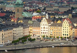
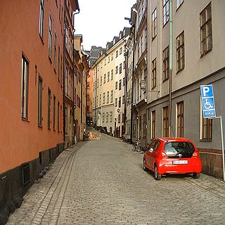
Trångsund is a short, narrow street in Gamla stan, the old town of Stockholm, Sweden. Stretching from Stortorget in front of Storkyrkan to Storkyrkobrinken, it is intercepted by Ankargränd and Spektens Gränd and forms a parallel street to Prästgatan and Källargränd.

Skeppar Karls Gränd alley in Gamla stan, Stockholm, Sweden

Skeppar Karls Gränd is an alley in Gamla stan, the old town of Stockholm, Sweden. Stretching from Skeppsbron to Österlånggatan, it forms a parallel street to Telegrafgränd and Bredgränd.

Bredgränd alley in Gamla stan, Stockholm, Sweden

Bredgränd is an alley in Gamla stan, the old town of Stockholm, Sweden. Stretching from Skeppsbron to Österlånggatan, it forms a parallel street to Skeppar Karls Gränd and Kråkgränd.

Mårten Trotzigs Gränd alley in Gamla stan, Stockholm, Sweden

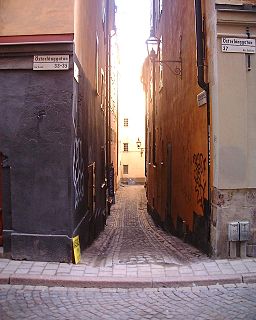
Mårten Trotzigs gränd is an alley in Gamla stan, the old town of Stockholm, Sweden. Leading from Västerlånggatan and Järntorget up to Prästgatan and Tyska Stallplan, the width of its 36 steps tapers down to a mere 90 centimetres (35 in), making the alley the narrowest street in Stockholm.

Lilla Hoparegränd alley in Gamla stan, Stockholm, Sweden

Lilla Hoparegränd is an alley in Gamla stan, the old town of Stockholm, Sweden. Passing between Skeppsbron and Österlånggatan, it forms a parallel street to Ferkens Gränd, Gaffelgränd, Pelikansgränd, and Johannesgränd.

Drakens Gränd alley in Gamla stan, Stockholm, Sweden

Drakens Gränd is an alley in Gamla stan, the old town of Stockholm, Sweden. Stretching from Skeppsbron to Österlånggatan, it forms a parallel street to Stora Hoparegränd and Ferkens Gränd.

Johannesgränd alley in Gamla stan, Stockholm, Sweden

Johannesgränd is an alley in Gamla stan, the old town of Stockholm, Sweden, connecting Skeppsbron to Österlånggatan.

Yxsmedsgränd alley in Gamla stan, Stockholm, Sweden

Yxsmedsgränd is an alley in Gamla stan, the old town in central Stockholm, Sweden.

Funckens Gränd street in Gamla stan, Stockholm, Sweden

Funckens Gränd is an alley in Gamla stan, the old town in central Stockholm, Sweden. Leading south from the street Västerlånggatan to the square Kornhamnstorg, it forms a parallel street to Torgdragargränd and Triewaldsgränd.

Didrik Ficks Gränd alley in Gamla stan, Stockholm, Sweden

Didrik Ficks Gränd is an alley in Gamla stan, the old town of Stockholm, Sweden. Stretching from Västerlånggatan to Stora Nygatan, it forms a parallel street to Sven Vintappares Gränd and Yxsmedsgränd while passing on the south side of the small square Sven Vintappares Torg.

Fru Gunillas Gränd alley in Gamla stan, Stockholm, Sweden

Fru Gunillas Gränd is a historical alley in Gamla stan, the old town in central Stockholm, Sweden, once connecting Skeppsbron to Österlånggatan between Johannesgränd and Packhusgränd.

Klockgjutargränd alley in Gamla stan, Stockholm, Sweden

Klockgjutargränd is a small alley in Gamla stan, the old town in central Stockholm, Sweden. Passing under a low vault, it connects the street Västerlånggatan to the public square and courtyard Brantingtorget, forming a parallel street to Salviigränd and Kolmätargränd.

Källargränd street in Gamla stan, Stockholm, Sweden

Källargränd is an alley in Gamla stan, the old town in central Stockholm, Sweden, connecting Slottsbacken, the slope south of the Royal Palace, to the square Stortorget. It forms a parallel street to Trångsund and is intercepted by Trädgårdsgatan.

Schönfeldts Gränd street in Gamla stan, Stockholm, Sweden

Schönfeldts Gränd is an alley in Gamla stan, the old town in central Stockholm, Sweden. Stretching south-west from Stora Nygatan to Mälartorget it is crossed by Lilla Nygatan and Munkbrogatan, and forms a parallel street to Kåkbrinken and Lejonstedts Gränd.

Staffan Sasses Gränd alley in Gamla stan, Stockholm, Sweden

Staffan Sasses Gränd is a blind alley in Gamla stan, the old town in central Stockholm, Sweden. Stretching north from Köpmangatan, it forms a parallel street to Bollhusgränd and Peder Fredags Gränd.

Stora Gråmunkegränd alley in Gamla stan, Stockholm, Sweden

Stora Gråmunkegränd is an alley in Gamla stan, the old town in central Stockholm, Sweden. Stretching west from Västerlånggatan down to Munkbron and Munkbroleden, it is crossed by Stora Nygatan, and forms a parallel street to Storkyrkobrinken and Helga Lekamens Gränd.

Sven Vintappares Gränd alley in Gamla stan, Stockholm, Sweden

Sven Vintappares Gränd is a small alley in Gamla stan, the old town of Stockholm, Sweden. Stretching from Västerlånggatan to Stora Nygatan, it forms a parallel street to Överskärargränd and Didrik Ficks Gränd, while passing on the north side of the small square Sven Vintappares Torg.

Triewaldsgränd is an alley in Gamla stan, the old town in central Stockholm, Sweden. Stretching south from the square Järntorget to Kornhamnstorg and Munkbroleden, it forms a parallel street to Funckens Gränd and Järntorgsgatan.

Överskärargränd alley in Gamla stan, Stockholm, Sweden

Överskärargränd is an alley in Gamla stan, the old town in central Stockholm, Sweden. Stretching from Västerlånggatan to Stora Nygatan passing on the south side of Gåstorget, it forms a parallel street to Gåsgränd and Sven Vintappares Gränd.

Fisketorget or Fiskaretorget is a historical public square in Gamla stan, the old town in central Stockholm, Sweden. It was once located on the east shore of the island Stadsholmen, between the present streets Österlånggatan and Skeppsbron, and between the present alleys Nygränd and Brunnsgränd.

References

  1. "Innerstaden: Gamla stan". Stockholms gatunamn (in Swedish) (2nd ed.). Stockholm: Kommittén för Stockholmsforskning. 1992. p. 55. ISBN   91-7031-042-4.
  2. Fredrik Ulrik Wrangel (1912). "Stockholmiana I-IV: En vandring i staden 1646" (in Swedish). Project Runeberg. p. 385. Retrieved 2007-02-27.

Coordinates: 59°19′30.5″N18°04′06.8″E / 59.325139°N 18.068556°E / 59.325139; 18.068556

Geographic coordinate system Coordinate system

A geographic coordinate system is a coordinate system that enables every location on Earth to be specified by a set of numbers, letters or symbols. The coordinates are often chosen such that one of the numbers represents a vertical position and two or three of the numbers represent a horizontal position; alternatively, a geographic position may be expressed in a combined three-dimensional Cartesian vector. A common choice of coordinates is latitude, longitude and elevation. To specify a location on a plane requires a map projection.