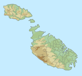
The geography of Malta is dominated by water. Malta is an archipelago of coralline limestone, located in Europe, in the Mediterranean Sea, 81 kilometres south of Sicily, Italy, and nearly 300 km north (Libya) and northeast (Tunisia) of Africa. Although Malta is situated in Southern Europe, it is located farther south than Tunis, capital of Tunisia, Algiers, capital of Algeria, Tangier in Morocco and also Aleppo in Syria, and Mosul in Iraq in the Middle East. Only the three largest islands – Malta, Gozo and Comino – are inhabited. Other (uninhabited) islands are: Cominotto, Filfla and the St.Paul's Islands. The country is approximately 316 km2 in area. Numerous bays along the indented coastline of the islands provide harbours. The landscape of the islands is characterised by high hills with terraced fields. The highest point, at 253 metres, Ta' Zuta on mainland Malta. The capital is Valletta.

This page gives an overview of the complex structure of environmental and cultural conservation in the United Kingdom.

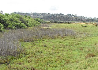
A salt marsh, saltmarsh or salting, also known as a coastal salt marsh or a tidal marsh, is a coastal ecosystem in the upper coastal intertidal zone between land and open saltwater or brackish water that is regularly flooded by the tides. It is dominated by dense stands of salt-tolerant plants such as herbs, grasses, or low shrubs. These plants are terrestrial in origin and are essential to the stability of the salt marsh in trapping and binding sediments. Salt marshes play a large role in the aquatic food web and the delivery of nutrients to coastal waters. They also support terrestrial animals and provide coastal protection.

Marsaxlokk is a small, traditional fishing village in the South Eastern Region of Malta. It has a harbour, and is a tourist attraction known for its views, fishermen and history. As of March 2014, the village had a population of 3,534. The village is also known for the Marsaxlokk Market, which is mainly a large fish market which takes place along the seafront on Sundays, and a tourist market during all other days of the week. Inhabited and well-known since antiquity, Marsaxlokk was used as a port by Phoenicians, Carthaginians and also has the remains of a Roman-era harbour. Originally a part of the city of Żejtun, the fishing village became a separate parish in the late nineteenth century.

The Macquarie Marshes Nature Reserve is a protected natural wetland reserve that is located within the Macquarie Marshes, in the region along the lower Macquarie River in northwestern New South Wales, Australia. The 19,824-hectare (48,990-acre) reserve is situated approximately 600 kilometres (370 mi) northwest of Sydney and 100 kilometres (62 mi) north of Warren.

A Ramsar site is a wetland site designated to be of international importance under the Ramsar Convention, also known as "The Convention on Wetlands", an international environmental treaty signed on 2 February 1971 in Ramsar, Iran, under the auspices of UNESCO. It came into force on 21 December 1975, when it was ratified by a sufficient number of nations. It provides for national action and international cooperation regarding the conservation of wetlands, and wise sustainable use of their resources. Ramsar identifies wetlands of international importance, especially those providing waterfowl habitat.

Tso Moriri or Lake Moriri or "Mountain Lake", is a lake in the Changthang Plateau of Ladakh in India. The lake and surrounding area are protected as the Tso Moriri Wetland Conservation Reserve.

A wet meadow is a type of wetland with soils that are saturated for part or all of the growing season which prevents the growth of trees and brush. Debate exists whether a wet meadow is a type of marsh or a completely separate type of wetland. Wet prairies and wet savannas are hydrologically similar.

Juncus acutus, the spiny rush, sharp rush or sharp-pointed rush, is a flowering plant in the monocot family Juncaceae. It is native to the Americas, Northern and Southern Africa, Western and Southern Europe and West Asia, and is found in a variety of wet habitats, such as bogs, fens, meadows, and salt marshes, and along the edges of ponds and lakes.
Harike Wetland also known as "Hari-ke-Pattan", with the Harike Lake in the deeper part of it, is the largest wetland in northern India in the border of Tarn Taran Sahib district and Ferozepur district of the Punjab state in India.
Brackish marshes develop from salt marshes where a significant freshwater influx dilutes the seawater to brackish levels of salinity. This commonly happens upstream from salt marshes by estuaries of coastal rivers or near the mouths of coastal rivers with heavy freshwater discharges in the conditions of low tidal ranges.

Wetland conservation is aimed at protecting and preserving areas where water exists at or near the Earth's surface, such as swamps, marshes and bogs. Wetlands cover at least six percent of the Earth and have become a focal issue for conservation due to the ecosystem services they provide. More than three billion people, around half the world's population, obtain their basic water needs from inland freshwater wetlands. The same number of people rely on rice as their staple food, a crop grown largely in natural and artificial wetlands. In some parts of the world, such as the Kilombero wetland in Tanzania, almost the entire local population relies on wetland cultivation for their livelihoods.

Marievale Bird Sanctuary is a protected area in Gauteng, South Africa. It is about 15 km2 in size, and situated on the East Rand on the southern half of the Blesbokspruit wetland, a Ramsar site. The Blesbokspruit is a major perennial river in Gauteng which is flanked by extensive floodplains on either side. Nearby is the Suikerbosrand Nature Reserve.

Ham Wall is an English wetland National Nature Reserve (NNR) 4 kilometres (2.5 mi) west of Glastonbury on the Somerset Levels. It is managed by the Royal Society for the Protection of Birds (RSPB). Since the last Ice Age, decomposing plants in the marshes of the Brue valley in Somerset have accumulated as deep layers of peat that were commercially exploited on a large scale in the twentieth century. Consumer demand eventually declined, and in 1994 the landowners, Fisons, gave their old workings to what is now Natural England, who passed the management of the 260 hectares Ham Wall section to the RSPB.

Australia has approximately 11,500 km2 of mangroves, primarily on the northern and eastern coasts of the continent. Areas where mangroves occur include the intertidal zone of tropical, subtropical and protected temperate coastal rivers, estuaries, bays and marine shorelines. Less than 1% of Australia's total forest area is mangrove forest.

The Lower Moors is a wetland between Hugh Town and Old Town Bay on St Mary's, the largest island in the Isles of Scilly. The Isles of Scilly are an archipelago off the southwestern tip of the Cornish peninsula of Great Britain.
Jubho Lagoon is a large shallow brackish lagoon located in Sindh, Pakistan. In May 2011 Jubhoo lagoon was inducted into the list of Ramsar sites, consisting of wetlands of international importance.

The Vatnsmýrin Nature Reserve is a protected moorland in Reykjavík, Iceland. The reserve provides a water source for Tjörnin Lake and is a nesting ground for birds. It borders the Nordic House and the University of Iceland. The area within the Reserve including drains and fences, and measures 37,026 square metres (398,540 sq ft). Eighty-three species of vascular plants are documented. Biodiversity has been inhibited due to invasive animals and plants as well as industrial waste.

Simar Nature Reserve is a nature reserve in Pwales Valley, in Xemxija, St Paul's Bay, Malta. An artificial wetland habitat was created in the 1990s by BirdLife Malta volunteers in an area of abandoned marshland.
Sri Lanka exhibits a remarkable biological diversity and is considered to be the richest country in Asia in terms of species concentration.