Urambo District is one of the seven districts of the Tabora Region of Tanzania. It is bordered to the north by the Kaliua District, to the east by the Uyui District, to the southeast by the Sikonge District, and to the southwest by the Katavi Region. Its administrative seat is the town of Urambo.

Nzega District is one of the seven districts of the Tabora Region of Tanzania. It is bordered to the north by Shinyanga Region, to the south and southwest by the Uyui District and to the east by the Igunga District. Its administrative seat is the town of Nzega.

Biharamulo District is one of the eight districts of the Kagera Region of Tanzania. It is bordered to the north by Karagwe District and Muleba District, to the east and south by Geita Region, to the west by Ngara District, and to the southwest by the Kigoma Region. Its administrative seat is Biharamulo town. Biharamulo Game Reserve is located within the borders of the district.
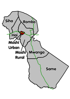
Moshi Urban is one of the seven districts of the Kilimanjaro Region of Tanzania. The regional capital of Moshi is located in the Moshi Urban District. The district is bordered to the north by the Moshi Rural District, to the east by the Mwanga District and to the south and west by the Manyara Region.

Itigi is a town in central Tanzania. It is located in Manyoni District of the Singida Region.
Mkonze is an administrative ward in the Dodoma Urban district of the Dodoma Region of Tanzania. According to the 2002 and 2012 census., the ward has a total population of 13,602.
Kondoa is a town and administrative ward in the Kondoa District of the Dodoma Region of Tanzania. According to the 2012 Tanzania National Census, the population of Kondoa Ward was 14,382. According to the 2002 census, the ward had a total population of 21,878.
Dabil is an administrative ward in the Babati Rural District of the Manyara Region of Tanzania. According to the 2002 census, the ward has a total population of 13,769.
Dareda is an administrative ward and a town in the Babati Rural District of the Manyara Region of Tanzania. According to the 2002 census, the ward has a total population of 18,013.
Kiru is an administrative ward in the Babati Rural District of the Manyara Region of Tanzania. According to the 2002 census, the ward has a total population of 11,180.
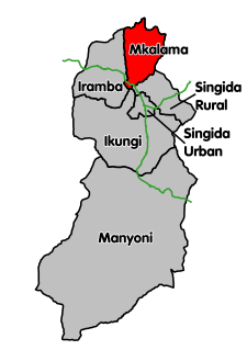
Gumanga is an administrative ward in the Mkalama District of the Singida Region of Tanzania. According to the 2002 census, the ward has a total population of 9,896. According to the 2012 census, the population had increased to 10,948.
Ibaga is an administrative ward in the Mkalama District of the Singida Region of Tanzania. According to the 2002 census, the ward has a total population of 10,672. According to the 2012 census, the population had increased to 11,712.
Iguguno is an administrative ward in the Mkalama District of the Singida Region of Tanzania. According to the 2002 census, the ward had a total population of 21,617. The town is popular business center for crops like cereals and sunflower. It is arguably the most developed town in the district. According to the 2012 census, the population had increased to 25,860.
Mpambala is an administrative ward in the Mkalama District of the Singida Region of Tanzania. According to the 2002 census, the ward had a total population of 10,882. According to the 2012 census, the population had increased to 11,192.
Msingi is an administrative ward in the Mkalama District of the Singida Region of Tanzania. According to the 2002 census, the ward has a total population of 6,439. According to the 2012 census, the population had increased to 7,289.
Mwanga is an administrative ward in the Mkalama District of the Singida Region of Tanzania. According to the 2002 census, the ward had a total population of 21,474. According to the 2012 census, the population had increased to 26,024.
Mwangeza is an administrative ward in the Mkalama District of the Singida Region of Tanzania. According to the 2002 census, the ward has a total population of 12,445. According to the 2012 census, the population had increased to 19,258.
Ndago is an administrative ward in the Iramba district of the Singida Region of Tanzania. According to the 2002 census, the ward has a total population of 12,332.
Nduguti is an administrative ward in the Mkalama District of the Singida Region of Tanzania. According to the 2002 census, the ward has a total population of 15,955. According to the 2012 census, the population had decreased to 8,638.
Nkinto is an administrative ward in the Mkalama District of the Singida Region of Tanzania. According to the 2002 census, the ward has a total population of 13,367. According to the 2012 census, the population had decreased to 10,372.