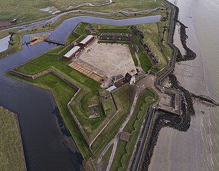
Tilbury Fort, also known historically as the Thermitage Bulwark and the West Tilbury Blockhouse, is an artillery fort on the north bank of the River Thames in England. The earliest version of the fort, comprising a small blockhouse with artillery covering the river, was constructed by King Henry VIII to protect London against attack from France as part of his Device programme. It was reinforced during the 1588 Spanish Armada invasion scare, after which it was reinforced with earthwork bastion, and Parliamentary forces used it to help secure the capital during the English Civil War of the 1640s. Following naval raids during the Anglo-Dutch Wars, the fort was enlarged by Sir Bernard de Gomme from 1670 onwards to form a star-shaped defensive work, with angular bastions, water-filled moats and two lines of guns facing onto the river.

Beacon Hill Battery is a late-19th and 20th century coastal fortification that was built to defend the port of Harwich, Essex. It is a scheduled ancient monument.

Fort Dunree is a coastal defence fortification located on the west side of the Inishowen peninsula, County Donegal, Ireland.

Lenan Head Fort, Lough Swilly, Inishowen, County Donegal was built in 1895, initially with three 9.2 inch Breech Loading (BL) guns. Following recommendations of the Owen Committee in 1905, it was refitted in 1911 with two newer Mark X 9.2 inch models. Both guns were operational during the First World War.

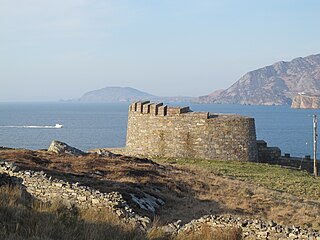
Ned's Point Fort is one of several Napoleonic batteries built along the shores of Lough Swilly in county Donegal, to defend the north west of Ireland. It was part of a scheme to fortify Lough Swilly and Lough Foyle against French Invasion during the Revolutionary and Napoleonic Wars. It is situated on Ned's Point, near the once important naval town of Buncrana, and its current form largely dates to works completed between 1812 and 1813. It comprised a rectangular blockhouse mounting two guns and a supporting battery mounting four guns. The fort is surrounded by a ditch.
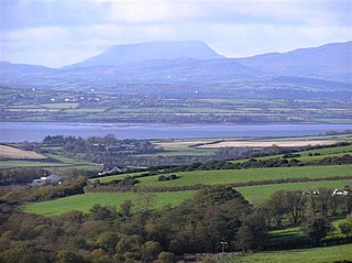
Lough Swilly in Ireland is a glacial fjord or sea inlet lying between the western side of the Inishowen Peninsula and the Fanad Peninsula, in County Donegal. Along with Carlingford Lough and Killary Harbour it is one of three glacial fjords in Ireland.

Fort Gilkicker is a historic Palmerston fort built at the eastern end of Stokes Bay, Gosport, Hampshire England to dominate the key anchorage of Spithead. It was erected between 1863 and 1871 as a semi-circular arc with 22 casemates, to be armed with five twelve-inch guns, seventeen ten-inch guns and five nine-inch guns. The actual installed armament rather differed from this. In 1902 the RML guns were replaced by two 9.2-inch and two six-inch BL guns, and before the First World War the walls were further strengthened with substantial earthwork embankments. The fort was disarmed in 1956 and used for storage until 1999, and is currently in a state of disrepair.

Pendennis Castle is an artillery fort constructed by Henry VIII near Falmouth, Cornwall, England between 1540 and 1542. It formed part of the King's Device programme to protect against invasion from France and the Holy Roman Empire, and defended the Carrick Roads waterway at the mouth of the River Fal. The original, circular keep and gun platform was expanded at the end of the century to cope with the increasing Spanish threat, with a ring of extensive stone ramparts and bastions built around the older castle. Pendennis saw service during the English Civil War, when it was held by the Royalists, and was only taken by Parliament after a long siege in 1646. It survived the interregnum and Charles II renovated the fortress after his restoration to the throne in 1660.

Following the establishment of the Irish Free State, three deep water Treaty Ports at Berehaven, Spike Island, and Lough Swilly were retained by the United Kingdom in accordance with the Anglo-Irish Treaty of 6 December 1921.

The Palmerston Forts are a group of forts and associated structures around the coasts of the United Kingdom and Ireland.

St Catherine's Castle is a Henrician castle in Cornwall, England, built by Thomas Treffry between approximately 1538 and 1540, in response to fears of an invasion of England by France and the Holy Roman Empire. The D-shaped, stone fortification, equipped with five gun-ports for cannon, overlooked the mouth of the River Fowey in Cornwall. It was protected by a curtain wall and the surrounding cliffs. The castle remained in use for many years until it was closed at the end of the Napoleonic Wars in 1815. Brought back into service in 1855 during the Crimean War, it was fitted with two new artillery positions, but it soon became obsolete and was abandoned. During the Second World War the castle was refortified and used to house a battery of naval guns, protecting the coast against the threat of German attack. At the end of the conflict the castle was restored to its previous condition and is now managed by English Heritage as a tourist attraction.
HMS Saldanha was a 36-gun fifth-rate Apollo-class frigate of the Royal Navy. She was commissioned in April 1810 and spent her entire career serving on the Irish Station, including capturing a fast-sailing French privateer on 11 October 1811. In the evening of 4 December that year Saldanha was serving off Lough Swilly when she was caught in a storm. Last seen sailing off Fanad Head, the ship was wrecked in a nearby bay with every person on board being killed and the only survivors being a parrot and a dog. The wreck was memorialised by Thomas Sheridan in his poem The Loss of the Saldanha.

The BL 6-inch gun Mark VII was a British naval gun dating from 1899, which was mounted on a heavy travelling carriage in 1915 for British Army service to become one of the main heavy field guns in the First World War, and also served as one of the main coast defence guns throughout the British Empire until the 1950s.

Camden Fort Meagher is a coastal defence fortification close to Crosshaven, County Cork, Ireland. Together with similar structures at Fort Mitchell, Fort Davis (Whitegate), and Templebreedy Battery, the fort was built to defend the mouth of Cork Harbour. Though originally constructed in the 16th century, the current structures of the fort date to the 1860s. Originally named Fort Camden and operated by the British Armed Forces, the fort was handed-over to the Irish Defence Forces in 1938. Renamed Fort Meagher in honour of Thomas Francis Meagher, it remained an Irish military installation until 1989 when the Irish Army handed the fort over to Cork County Council. It remained largely overgrown until 2010 when a group of local volunteers began restoration and development of the fort for heritage and tourism purposes. The fort was renamed Camden Fort Meagher and is now open seasonally to visitors, with exhibits on the fort's Brennan torpedo installation.

Fort Davis, is a coastal defence fortification close to Whitegate, County Cork, Ireland. Together with similar structures at Fort Mitchel, Fort Camden (Crosshaven), and Templebreedy Battery, the fort was built to defend the mouth of Cork Harbour. Though used as a fortification from the early 17th century, the current structures of the 74-acre site date primarily from the 1860s. Originally named Fort Carlisle and operated by the British Armed Forces, the fort was handed-over to the Irish Defence Forces in 1938, and renamed Fort Davis. The facility is owned by the Department of Defence, and is used as a military training site with no public access.

West Blockhouse Fort is a mid-19th century coastal artillery fort at West Blockhouse Point, a rocky headland near Dale, Pembrokeshire, to the west of Milford Haven in Wales.
Grey Point Fort is a battery located at Helen's Bay on the south side of Belfast Lough. It was part of the defences of Belfast.
The Antrim Artillery was a part-time reserve unit of Britain's Royal Artillery based in County Antrim, Northern Ireland, from 1853 to 1919. It numbered 1st on the order of precedence of the Militia Artillery. Volunteers from the unit served in the Second Boer War. During World War I it defended Belfast Lough and trained gunners for service overseas. Subsequent units continued the Antrim Artillery traditions.

Macamish Fort is one of several Napoleonic batteries built along the shores of Lough Swilly in county Donegal, to defend the north west of Ireland. It was part of a scheme to fortify Lough Swilly and Lough Foyle against French Invasion during the Revolutionary and Napoleonic Wars and was completed between 1812 and 1813. It was built on a rock outcrop overlooking the lough. It comprises a Martello Tower mounting a single gun and battery mounting three guns. The fort was originally entered by a drawbridge.
Knockalla Fort is one of several Napoleonic batteries built along the shores of Lough Swilly in county Donegal, to defend the north west of Ireland. It was part of a scheme to fortify Lough Swilly and Lough Foyle against French Invasion during the Revolutionary and Napoleonic Wars and was completed between 1812 and 1813. On the other side of the Lough is Fort Dunree. The fort was built on the site of a temporary fortification first built in 1798.
