| | |
| Founded | 1980 |
|---|---|
| Headquarters | , |
Indian School Fujairah is an educational institute based in Fujairah, UAE. It was established in 1980. [1]
It follows Kerala syllabus.
| | |
| Founded | 1980 |
|---|---|
| Headquarters | , |
Indian School Fujairah is an educational institute based in Fujairah, UAE. It was established in 1980. [1]
It follows Kerala syllabus.

The Emirate of Fujairah is one of the seven emirates that make up the United Arab Emirates. The only of the seven with a coastline solely on the Gulf of Oman and none on the Persian Gulf, its capital is Fujairah.
Jabal Al-Mebraḥ, also commonly mistakenly referred to by the name of the nearby peak Jabal Yibir, is a 1,505 m (4,938 ft) tall mountain in the United Arab Emirates (UAE).

Sheikh Hamad bin Mohammed Al Sharqi is an Emirati royal and politician who currently serves as the ruler of the Emirate of Fujairah, and served as the first minister of agriculture and fisheries in the United Arab Emirates between 1971 and 1974.
German submarine U-533 was a Type IXC/40 U-boat of Nazi Germany's Kriegsmarine during World War II. The submarine was laid down on 17 February 1942 at the Deutsche Werft yard at Hamburg as yard number 351, launched on 11 September 1942 and commissioned on 25 November 1942 under the command of Kapitänleutnant Helmut Hennig. After training with the 4th U-boat Flotilla in the Baltic Sea, U-533 was transferred to the 10th flotilla for front-line service on 1 May 1943, and sunk in the Gulf of Oman on 16 October with one survivor.
Dahir is the name of a settlement in Fujairah.

Dibba Al-Hisn is a pene-exclave of the emirate of Al-Sharjah, one of the seven United Arab Emirates. It is bordered by the Gulf of Oman from the East, Dibba Al-Baya from the North, and Dibba Al-Fujairah from the South. It is also geographically part of the Dibba region. It is the smallest in size among the Dibbas. It is mostly known for its fish market and the ancient fortress from which it got its name. Also, it is known for its high density of population relative to the other Dibbas.

The University of Fujairah (UOF) is a higher education institution in Fujairah City, capital city of Fujairah, United Arab Emirates. It was originally founded as Fujairah College in 2006.
Murtizapur Assembly constituency is one of the 288 constituencies of Maharashtra Vidhan Sabha and one of the five which are located in the Akola district. It is reserved for a Scheduled Caste candidate.
The 2011 WPA World Eight-ball Championship was an eight-ball world championship, organized by the World Pool-Billiard Association (WPA), and held 19–26 February 2011 at the Fujairah Exhibition Centre of the Al Diar Siji Hotel in Fujairah, United Arab Emirates. A total of 116 players from all of the WPA's six regions participated.
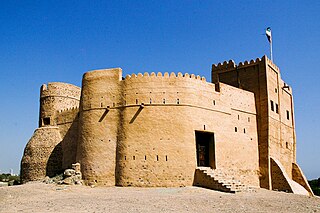
Fujairah Fort is a fort in the city of Fujairah, United Arab Emirates (UAE). Dating back to the 16th century, it is among the oldest as well as the largest castles in the country. It is noted for playing significant roles in fighting back the wave of colonialism. Today, it is among the main tourist attractions in the city. It is probably the oldest fort in the UAE and was occupied by the Wahhabists.

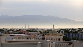
Fujairah City is the capital of the emirate of Fujairah in the United Arab Emirates. It is the seventh-largest city in UAE, located on the Gulf of Oman. It is the only Emirati capital city on the UAE's east coast. The city of Fujairah is an industrial and commercial hub located on the west coast of the Indian Ocean that sits at the foothills of the Hajar Mountains.

Fujairah Beach is on the Gulf of Oman, located on the northern part of Fujairah City, Emirate of Fujairah, United Arab Emirates.

Hamad Bin Abdulla Road is the main road running east–west through Fujairah City, Emirate of Fujairah, United Arab Emirates.
Fujairah Free Zone (FFZ) is a special economic zone in Fujairah, which is one of the seven emirates that comprise the United Arab Emirates. Fujairah Free Zone is located just north of the emirate's capital, Fujairah City. It is run by the Fujairah Free Zone Authority (FFZA).

Fujairah Heritage Village is a heritage-based tourist attraction located close to Madhab Spring Park and Madhab Palace, northwest of Fujairah City, Emirate of Fujairah, United Arab Emirates (UAE).
Madhab Spring Park is a park, mineral spring, and tourist attraction located close to Fujairah Heritage Village, northwest of Fujairah City, Emirate of Fujairah, United Arab Emirates (UAE).
The Fujairah Corniche is a seafront corniche located at the east end of Hamad Bin Abdulla Road in Fujairah City, Emirate of Fujairah, United Arab Emirates, providing recreational facilities for residents and visitors. It is on the coast of the Gulf of Oman in the Indian Ocean.

Sakamkam Fort is a historic fort in Sakamkam, just north of Fujairah City, Emirate of Fujairah, United Arab Emirates.
Madhab Palace is a palace located in the Madhab district on the northwest edge of Fujairah City, Emirate of Fujairah, United Arab Emirates (UAE). It is close to Fujairah Heritage Village and Madhab Spring Park.
25°08′57″N56°20′59″E / 25.14916°N 56.34975°E
| | This United Arab Emirates school-related article is a stub. You can help Wikipedia by expanding it. |