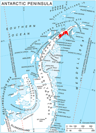
The Scaife Mountains is a group of mountains rising west of Prehn Peninsula and between the Ketchum and Ueda glaciers, in Palmer Land, at the base of Antarctic Peninsula.

Poľany is a village and municipality in the Trebišov District in the Košice Region of south-eastern Slovakia.
The Blackburn River is on West Falkland in the Falkland Islands. It is in the north of the island, and empties into Byron Sound. The name is a tautology, since "burn" is a Lowland Scots/Northern English word referring to a small river or large brook.

The Roman Catholic Diocese of Gurué is a diocese located in the city of Gurué in the Ecclesiastical province of Beira in Mozambique.

Calzadilla de Tera is a municipality located in the province of Zamora, Castile and León, Spain. According to the 2004 census (INE), the municipality has a population of 467 inhabitants.

Gurué District is a district of Zambezia Province in Mozambique. The principal town is Gurué. Gurué is the country's largest tea-estate and has a population of around 116, 922.

Itaigara is a neighbourhood located in the southeastern zone of Salvador, Bahia. Modern and bold lies in a region "noble" of the capital Bahia, inhabited mainly by people with high purchasing power.

Malba is a department or commune of Poni Province in southern Burkina Faso. Its capital lies at the town of Malba.
The Taifa of Baeza was a medieval taifa Moorish kingdom. It existed only from 1224 to 1226, when it fell to the Christian Kingdom of Castile.
Gagal Bhadaure is a village development committee in Ramechhap District in the Janakpur Zone of north-eastern Nepal. At the time of the 1991 Nepal census it had a population of 2,596 people living in 468 individual households.

Dinsmoor Glacier is a glacier in the Nordenskjöld Coast of Antarctica, named for inventor Charles Dinsmoor. It flows east from the Detroit Plateau, and merges with the Edgeworth Glacier near Mount Elliott before draining into Mundraga Bay.
The Wellington Strait is a natural waterway through the central Canadian Arctic Archipelago in the territory of Nunavut. It separates the Tennent Islands from Matty Island. To the north, the strait opens into the James Ross Strait; to the south it opens into the Rae Strait.
The Taipa River is a river of the northern Northland Region of New Zealand's North Island. It flows west then north, reaching the south of Doubtless Bay at the township of Taipa.
Zhitosvyat is a village in Karnobat Municipality, in Burgas Province, in southeastern Bulgaria.
Cape Juncal is a prominent cape forming the northwestern extremity of D'Urville Island, in the Joinville Island group, Antarctica. The name appears on an Argentine government chart of 1957 and was applied in remembrance of the Argentine naval victory of 1827 at the Battle of Juncal.
Mount Hanssen is an ice-covered mountain distinguished by a sharp peak, 3,280 metres (10,760 ft) high, standing at the southernmost point of Rawson Plateau in the Queen Maud Mountains of Antarctica. It was discovered by Captain Roald Amundsen while en route to the South Pole in November 1911, and named by him for Helmer Hanssen, deputy leader of the South Pole party.
Kabta, Idlib is a Syrian village located in Armanaz Nahiyah in Harem District, Idlib. According to the Syria Central Bureau of Statistics (CBS), Kabta, Idlib had a population of 1229 in the 2004 census.


