Inkerman Ferry, New Brunswick

Last updated

Inkerman Ferry is a community in the Canadian province of New Brunswick, located on Inkerman Lake. The community is centred on the intersection of Route 345 and Route 113.

Provinces and territories of Canada Top-level subdivisions of Canada

The provinces and territories of Canada are the sub-national governments within the geographical areas of Canada under the authority of the Canadian Constitution. In the 1867 Canadian Confederation, three provinces of British North America—New Brunswick, Nova Scotia, and the Province of Canada —were united to form a federated colony, becoming a sovereign nation in the next century. Over its history, Canada's international borders have changed several times, and the country has grown from the original four provinces to the current ten provinces and three territories. Together, the provinces and territories make up the world's second-largest country by area.

New Brunswick province in Canada

New Brunswick is one of four Atlantic provinces on the east coast of Canada. According to the Constitution of Canada, New Brunswick is the only bilingual province. About two thirds of the population declare themselves anglophones and a third francophones. One third of the overall population describe themselves as bilingual. Atypically for Canada, only about half of the population lives in urban areas, mostly in Greater Moncton, Greater Saint John and the capital Fredericton.

Route 345 is a 12-kilometre (7.5 mi) long east–west secondary riverfront highway in the north-east portion of New Brunswick, Canada.

Contents

History

Notable people

See also

Related Research Articles

Gloucester County, New Brunswick County in New Brunswick, Canada

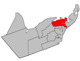
Gloucester County is located in the northeastern corner of New Brunswick, Canada. Fishing, mining and forestry are the major industries in the county. The eastern section of the county is known for its Acadian culture.

Shippagan Town in New Brunswick, Canada

Shippagan is a Canadian town in Gloucester County, New Brunswick.

Bas-Caraquet, New Brunswick Village in New Brunswick, Canada

Bas-Caraquet is a Canadian village in Gloucester County, New Brunswick.

Bertrand, New Brunswick Village in New Brunswick, Canada

Bertrand is a Canadian village in Gloucester County, New Brunswick.

Paquetville Village in New Brunswick, Canada

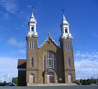
Paquetville is a Canadian village in Gloucester County, New Brunswick. at the intersection of Route 340, Route 135 and Route 350. It is located on the Acadian Peninsula.

Pokemouche River river in New Brunswick, Canada

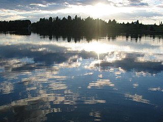
The Pokemouche River is in north eastern New Brunswick, Canada. The name is derived from the Algonquin language. Its headwaters are near the community of Paquetville, and it flows in an easterly direction approximately twenty kilometers where it empties into the Gulf of St. Lawrence at Inkerman Lake. Other communities along its watershed include Maltampec and Pokemouche. Its tributaries include South Branch Pokemouche River, Cowans Creek, and the Waugh River.

Allison, New Brunswick human settlement in New Brunswick, Canada

Allison is a community in Moncton Parish, New Brunswick on Route 106.

Inkerman Parish, New Brunswick Parish in New Brunswick, Canada

Inkerman is a Canadian parish in Gloucester County, New Brunswick. The local service district of the same name, which included only part of the parish, was incorporated into the Regional Municipality of Grand Tracadie–Sheila on July 1, 2014, causing some misunderstanding of its status.

Pokemouche, New Brunswick Local Service District in New Brunswick, Canada

Pokemouche is a Canadian local service district in Gloucester County, in the northeast of New Brunswick, in the Acadian peninsula.

Inkerman is a community in the Canadian province of New Brunswick on the Inkerman Lake. The Community is located mainly on Route 113. See also Inkerman Parish.

Caraquet Parish, New Brunswick Parish in New Brunswick, Canada

Caraquet is a Canadian parish in Gloucester County, New Brunswick.

Coteau Road, New Brunswick human settlement in New Brunswick, Canada

Coteau Road is a settlement in New Brunswick. This Community is located almost exclusively on Route 310

Losier Settlement, New Brunswick human settlement in New Brunswick, Canada

Losier Settlement was a settlement in New Brunswick. There are 3 major highways that intersections with Losier Settlement, Route 11, Route 150, Route 160. It is now part of the Regional Municipality of Grand Tracadie–Sheila.

Rivière-du-Portage, New Brunswick river in New Brunswick, Canada

Rivière-du-Portage was a settlement in Northumberland County, New Brunswick at the intersection of Route 11 and the eastern terminus of Route 370. This community was incorporated into the Regional Municipality of Grand Tracadie–Sheila.

Sainte-Rose, New Brunswick human settlement in New Brunswick, Canada

Sainte-Rose was a settlement in New Brunswick. The community includes Haute-Sainte-Rose and Sainte-Rose-Gloucester. The community is located mainly on Route 355. It is now part of the Regional Municipality of Tracadie.

Turtle Creek is a community Southwest of Riverview, in Albert County, New Brunswick. The community is located on named after the Turtle Creek and is located on Route 910.

Irishtown, New Brunswick human settlement in New Brunswick, Canada

Irishtown is a community located in Westmorland County, New Brunswick, Canada. The community is situated in southeastern New Brunswick, to the north of Moncton on Route 115.

Evangeline, Gloucester County, New Brunswick human settlement in New Brunswick, Canada

Evangeline is a community in the Canadian province of New Brunswick. The community is located mainly on Route 345.

Six-Roads, New Brunswick human settlement in New Brunswick, Canada

Six-Roads is a settlement in New Brunswick, Canada. The Community is located mainly at the intersection of Route 355 and Route 11.

Route 525 is a 10-kilometre (6.2 mi) long east-west secondary highway in the northwest portion of New Brunswick, Canada.

References

    Coordinates: 47°40′53″N64°48′45″W / 47.681281°N 64.812598°W / 47.681281; -64.812598

    Geographic coordinate system Coordinate system

    A geographic coordinate system is a coordinate system that enables every location on Earth to be specified by a set of numbers, letters or symbols. The coordinates are often chosen such that one of the numbers represents a vertical position and two or three of the numbers represent a horizontal position; alternatively, a geographic position may be expressed in a combined three-dimensional Cartesian vector. A common choice of coordinates is latitude, longitude and elevation. To specify a location on a plane requires a map projection.