Related Research Articles

Fife is a council area, historic county, registration county and lieutenancy area of Scotland. It is situated between the Firth of Tay and the Firth of Forth, with inland boundaries with Perth and Kinross and Clackmannanshire. By custom it is widely held to have been one of the major Pictish kingdoms, known as Fib, and is still commonly known as the Kingdom of Fife within Scotland. A person from Fife is known as a Fifer. In older documents the county was very occasionally known by the anglicisation Fifeshire.
Firth is a word in the English and Scots languages used to denote various coastal waters in the United Kingdom, predominantly within Scotland. In the Northern Isles, it more often refers to a smaller inlet. It is linguistically cognate to Scandinavian fjord and fjard, with the original meaning of "sailable waterway". The word has a more constrained sense in English. Bodies of water named "firths" tend to be more common on the Scottish east coast, or in the southwest of the country, although the Firth of Clyde is an exception to this. The Highland coast contains numerous estuaries, straits, and inlets of a similar kind, but not called "firth" ; instead, these are often called sea lochs. Before about 1850, the spelling "Frith" was more common.

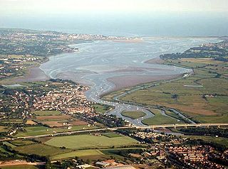
The Firth of Tay is a firth on the east coast of Scotland, into which empties the River Tay. The firth is surrounded by four council areas: Fife, Perth and Kinross, Dundee City, and Angus. Its maximum width is 3 mi (4.8 km).

The River Tay is the longest river in Scotland and the seventh-longest in Great Britain. The Tay originates in western Scotland on the slopes of Ben Lui, then flows easterly across the Highlands, through Loch Dochart, Loch Iubhair and Loch Tay, then continues east through Strathtay, in the centre of Scotland, then southeasterly through Perth, where it becomes tidal, to its mouth at the Firth of Tay, south of Dundee. It is the largest river in the United Kingdom by measured discharge. Its catchment is approximately 2,000 square miles, the Tweed's is 1,500 sq mi (3,900 km2) and the Spey's is 1,097 sq mi (2,840 km2).
The Exe estuary is an estuary on the south coast of Devon, England.

Burton Mere Wetlands is a nature reserve on the Dee Estuary straddling the border between Cheshire, England and Flintshire, Wales. It is run by the Royal Society for the Protection of Birds (RSPB) and incorporates the older Inner Marsh Farm reserve. It lies near the village of Burton, about 3 kilometres (1.9 mi) south of Neston. It has all been developed by the RSPB and includes a large area of mixed wetland habitats, bluebell woodlands, and arable fields all managed to attract wildlife.

Havergate Island is the only island in the county of Suffolk, England. It is found at the confluence of the River Ore and the Butley River near the village of Orford. It is a marshy nature reserve run by the Royal Society for the Protection of Birds (RSPB) and is known for its population of pied avocets and terns. It is part of the ecologically important Alde-Ore Estuary and has protected conservation status as part of a national nature reserve, SSSI, SAC, SPA, Ramsar Site and is also a part of the Suffolk Coast and Heaths AONB.

Kinnoull Hill is a hill located partly in Perth and partly in Kinfauns, Perth and Kinross, Scotland. It shares its name with the nearby Kinnoull parish.

The Islands of the Forth are a group of small islands located in the Firth of Forth and in the estuary of the River Forth on the east coast of Scotland. Most of the group lie in the open waters of the firth, between the Lothians and Fife, with the majority to the east of the city of Edinburgh. Two islands lie further west in the river estuary.
The Edinburgh and Northern Railway was a railway company authorised in 1845 to connect Edinburgh to both Perth and Dundee. It relied on ferry crossings of the Firth of Forth and the Firth of Tay, but despite those disadvantages it proved extremely successful. It took over a short railway on the southern shore of the Forth giving a direct connection to Edinburgh, and it changed its name to the Edinburgh, Perth and Dundee Railway.

Marazion Marsh is a Royal Society for the Protection of Birds (RSPB) reserve situated in a shallow river valley, half a kilometre to the west of Marazion, Cornwall, UK. It is separated from the coast by a shingle bar and small sand dune system and contains Cornwall's largest reed bed.

The North Norfolk Coast Site of Special Scientific Interest (SSSI) is an area of European importance for wildlife in Norfolk, England. It comprises 7,700 ha (19,027 acres) of the county's north coast from just west of Holme-next-the-Sea to Kelling, and is additionally protected through Natura 2000, Special Protection Area (SPA) listings; it is also part of the Norfolk Coast Area of Outstanding Natural Beauty (AONB). The North Norfolk Coast is also designated as a wetland of international importance on the Ramsar list and most of it is a Biosphere Reserve.

Flisk was a parish in Fife, Scotland.

Suffolk Coast National Nature Reserve is a wildlife reserve on the North Sea coast of the English county of Suffolk. It is located around the village of Walberswick to the south of the town of Southwold. The reserve was designated in 2003, combining the existing Walberswick National Nature Reserve with reserves at Dingle Marshes and Hen Reedbeds to create a 1,340 hectares reserve.
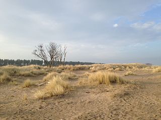
Tentsmuir National Nature Reserve (NNR) is located southeast of Tayport in Fife, Scotland. The reserve is made up of three parts, encompassing Morton Lochs, Tentsmuir Point and Tayport Heath, and is managed by NatureScot. The different sections of Tentsmuir NNR were originally designated as separate national nature reserves at different times: the Morton Lochs section was designated in 1952; Tentsmuir Point in 1954; and Tayport Heath in 1988. While these discrete sections are distant from one another, they form part of the extensive dune system at Tentsmuir, and in 2003 SNH combined the three sites to form Tentsmuir National Nature Reserve. The adjoining Tentsmuir Forest is managed by Forestry and Land Scotland and covers most of the land between the three portions of the NNR.

Aber Taf is a large Site of Special Scientific Interest (SSSI) in Carmarthenshire, Wales, and forms part of the Carmarthen Bay and Estuaries Special Area of Conservation.
Loch Spynie is a small loch located between the towns of Elgin and Lossiemouth in Moray, Scotland. Close to Spynie Palace, the ancient home of the bishops of Moray, it is an important wildlife habitat which is protected as a Ramsar Site.

Hurst Castle and Lymington River Estuary is a 1,077.3-hectare (2,662-acre) biological and geological Site of Special Scientific Interest near Lymington in Hampshire. It is a Nature Conservation Review site and two areas are Geological Conservation Review sites. Three areas are local nature reserves, Boldre Foreshore, Sturt Pond and Lymington and Keyhaven Marshes; the latter site is managed by the Hampshire and Isle of Wight Wildlife Trust. Part of it is North Solent National Nature Reserve. It is part of Solent and Southampton Water Ramsar site and Special Protection Area. Parts of it are in Solent Maritime and Solent and Isle of Wight Lagoons Special Areas of Conservation.
References
- ↑ "Inner Tay Estuary Site of Special Scientific Interest: Site management statement". Scottish Natural Heritage. Retrieved 3 January 2013.
- ↑ "Detailed information for Inner Tay Estuary LNR". Scottish Natural Heritage. Archived from the original on 6 November 2009. Retrieved 3 January 2013.
- ↑ "Inner Tay Estuary Local Nature Reserve Draft Two Management Plan" (PDF). Perth & Kinross Council. Retrieved 8 January 2013.[ permanent dead link ]
- ↑ "Central Environmental Surveys (2003). Habitat survey Inner Tay Estuary 2002]. Scottish Natural Heritage Commissioned Report No. 003 (ROAME No. F01LH04B)". Scottish Natural Heritage. Retrieved 4 January 2013.
- ↑ "Bates, C. R., Moore, C. G., Malthus, T., Mair, J. M. and Karpouzli, E. (2004). [ Broad scalemapping of habitats in the Firth of Tay and Eden Estuary, Scotland]. Scottish Natural Heritage Commissioned Report No. 007 (ROAME No. F01AA401D)". Scottish Natural Heritage. Retrieved 4 January 2013.